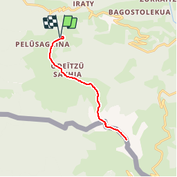
![](/images/other/stat-length.png)
![Tour Wandern Larrau - Pic d'Orhy - Photo](https://media.geolcdn.com/t/1900/400/ext.pjpeg?maxdim=2&url=https%3A%2F%2Fservices.sitytrail.com%2FGeolivesWS%2FDownloadMedia.ashx%3FTrailID%3D102597%26Media%3D3510_1.jpg)
Pic d'Orhy
tracegps
Benutzer
![Länge](/images/other/stat-length.png)
![Maximale Höhe](https://static1.geolcdn.com/siteimages/upload/files/1508320355ic_sort_altitude_max_24dp.png)
![Positive Höhendifferenz](https://static1.geolcdn.com/siteimages/upload/files/1508320355ic_sort_den_pos_24dp.png)
![Km-Effort](/images/other/stat-length.png)
![Min. Höhe](https://static1.geolcdn.com/siteimages/upload/files/1508320355ic_sort_altitude_min_24dp.png)
![Negative Höhendifferenz](https://static1.geolcdn.com/siteimages/upload/files/1508320355ic_sort_den_neg_24dp.png)
![Boucle](https://static1.geolcdn.com/siteimages/upload/files/16400158638029165_repeat_loop_refresh_sync_direction_icon.png)
![Wandern](https://static1.geolcdn.com/sitytour/trail-icons/101.png)
6h30
Schwierigkeit : Schwierig
![Scannen Sie diesen QR-Code, um die Tour in der SityTrail-Anwendung zu öffnen](https://capi.geolives.com/qq0zvz2zws4bq2lad0pu/sitytour/trails/102597/qr.png?size=200)
Kostenlosegpshiking-Anwendung
Über SityTrail
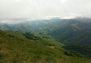
Tour Wandern von 13 km verfügbar auf Neu-Aquitanien, Pyrenäen-Atlantik, Larrau. Diese Tour wird von tracegps vorgeschlagen.
Beschreibung
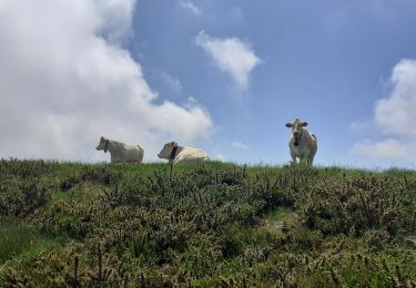
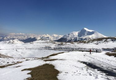
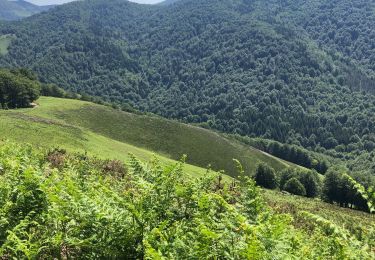
Le pic d'Orhy est situé à la frontière franco-espagnole, entre la Soule pour les Pyrénées-Atlantiques et la communauté Forale de Navarre. C'est le point culminant de la Soule à 2 017 m d'altitude. Il est le premier " 2000 " des Pyrénées, en venant de l’océan Atlantique, et ses dimensions imposantes en font le géant des Pyrénées basques. De son sommet on aperçoit le golfe de Gascogne, le pic d'Anie et côté Béarn à l'est, les plus hauts sommets des Pyrénées. (source Wikipedia)
Ort
Kommentare
Touren in der Umgebung
![Tour Wandern Larrau - IRATY le pic des escaliers sans monter au pic 408M+ 2948308 - Photo](https://media.geolcdn.com/t/375/260/1725c3fb-51a3-4e7e-9d48-19cb60baeea0.jpg&format=jpg&maxdim=2)
![Wandern Wandern](https://static1.geolcdn.com/sitytour/trail-icons/101.png)
Wandern
![](/images/other/stat-length.png)
![](https://static1.geolcdn.com/siteimages/upload/files/16400158638029165_repeat_loop_refresh_sync_direction_icon.png)
![Tour Wandern Larrau - Iraty cabane ZINGOLATZE - Photo](https://media.geolcdn.com/t/375/260/44ee5c4f-fb20-4eee-9c16-d8a5e8350ada.jpg&format=jpg&maxdim=2)
![Wandern Wandern](https://static1.geolcdn.com/sitytour/trail-icons/101.png)
Wandern
![](/images/other/stat-length.png)
![](https://static1.geolcdn.com/siteimages/upload/files/16400158638029165_repeat_loop_refresh_sync_direction_icon.png)
![Tour Wandern Larrau - GR 10 T - Photo](https://media.geolcdn.com/t/375/260/5faacc01-4cf0-48af-992e-bb3842b7dc29.jpg&format=jpg&maxdim=2)
![Wandern Wandern](https://static1.geolcdn.com/sitytour/trail-icons/101.png)
Wandern
![](/images/other/stat-length.png)
![](https://static1.geolcdn.com/siteimages/upload/files/16400158638029165_repeat_loop_refresh_sync_direction_icon.png)
![Tour Wandern Larrau - le Pic des Escalier - Photo](https://media.geolcdn.com/t/375/260/25a58932-02ea-4249-a083-fd59fc4e847e.jpg&format=jpg&maxdim=2)
![Wandern Wandern](https://static1.geolcdn.com/sitytour/trail-icons/101.png)
Wandern
![](/images/other/stat-length.png)
![](https://static1.geolcdn.com/siteimages/upload/files/16400158638029165_repeat_loop_refresh_sync_direction_icon.png)
![Tour Wandern Lecumberry - Okabe magique - Photo](https://media.geolcdn.com/t/375/260/072c8693-4101-429d-bd0b-7f3d41337b96.jpg&format=jpg&maxdim=2)
![Wandern Wandern](https://static1.geolcdn.com/sitytour/trail-icons/101.png)
Wandern
![](/images/other/stat-length.png)
![](https://static1.geolcdn.com/siteimages/upload/files/16400158638029165_repeat_loop_refresh_sync_direction_icon.png)
![Tour Wandern Larrau - Iraty « escaliers » - Photo](https://media.geolcdn.com/t/375/260/42225316-23e6-495d-8c25-50310cc3c362.jpg&format=jpg&maxdim=2)
![Wandern Wandern](https://static1.geolcdn.com/sitytour/trail-icons/101.png)
Wandern
![](/images/other/stat-length.png)
![](https://static1.geolcdn.com/siteimages/upload/files/16400158638029165_repeat_loop_refresh_sync_direction_icon.png)
![Tour Wandern Lecumberry - IRATI : GOROSTIBIZKARRA 1340m - Photo](https://media.geolcdn.com/t/375/260/a59d3f76-fd9f-4aca-903e-cf76eaa1cfd9.jpg&format=jpg&maxdim=2)
![Wandern Wandern](https://static1.geolcdn.com/sitytour/trail-icons/101.png)
Wandern
![](/images/other/stat-length.png)
![](https://static1.geolcdn.com/siteimages/upload/files/16400158638029165_repeat_loop_refresh_sync_direction_icon.png)
![Tour Wandern Larrau - IRATY Chapelle Notre Dame des Neiges et Casas de Irati - Photo](https://media.geolcdn.com/t/375/260/4820dd3f-a315-4e52-ac6d-42397795308f.jpg&format=jpg&maxdim=2)
![Wandern Wandern](https://static1.geolcdn.com/sitytour/trail-icons/101.png)
Wandern
![](/images/other/stat-length.png)
![](https://static1.geolcdn.com/siteimages/upload/files/16400158638029165_repeat_loop_refresh_sync_direction_icon.png)
![Tour Wandern Lecumberry - IRATY PETRILARRE-HEGIXURIA en boucle - Photo](https://media.geolcdn.com/t/375/260/858f8db3-ac8d-4103-89b2-b5fb262d83c8.jpg&format=jpg&maxdim=2)
![Wandern Wandern](https://static1.geolcdn.com/sitytour/trail-icons/101.png)
Wandern
![](/images/other/stat-length.png)
![](https://static1.geolcdn.com/siteimages/upload/files/16400158638029165_repeat_loop_refresh_sync_direction_icon.png)