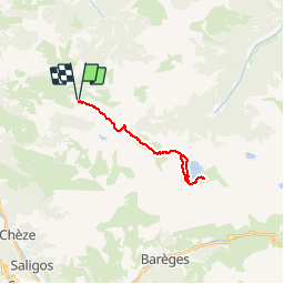
![](/images/other/stat-length.png)
![Tour Wandern Gazost - Moulata - Lac Vert - Photo](https://media.geolcdn.com/t/1900/400/ext.pjpeg?maxdim=2&url=https%3A%2F%2Fstatic1.geolcdn.com%2Fsiteimages%2Fupload%2Ffiles%2F1553511878bg_sport_marche.png)
Moulata - Lac Vert
tracegps
Benutzer
![Länge](/images/other/stat-length.png)
![Maximale Höhe](https://static1.geolcdn.com/siteimages/upload/files/1508320355ic_sort_altitude_max_24dp.png)
![Positive Höhendifferenz](https://static1.geolcdn.com/siteimages/upload/files/1508320355ic_sort_den_pos_24dp.png)
![Km-Effort](/images/other/stat-length.png)
![Min. Höhe](https://static1.geolcdn.com/siteimages/upload/files/1508320355ic_sort_altitude_min_24dp.png)
![Negative Höhendifferenz](https://static1.geolcdn.com/siteimages/upload/files/1508320355ic_sort_den_neg_24dp.png)
![Boucle](https://static1.geolcdn.com/siteimages/upload/files/16400158638029165_repeat_loop_refresh_sync_direction_icon.png)
![Wandern](https://static1.geolcdn.com/sitytour/trail-icons/101.png)
6h30
Schwierigkeit : Sehr schwierig
![Scannen Sie diesen QR-Code, um die Tour in der SityTrail-Anwendung zu öffnen](https://capi.geolives.com/qq0zvz2zws4bq2lad0pu/sitytour/trails/102592/qr.png?size=200)
Kostenlosegpshiking-Anwendung
Über SityTrail
Tour Wandern von 21 km verfügbar auf Okzitanien, Hautes-Pyrénées, Gazost. Diese Tour wird von tracegps vorgeschlagen.
Beschreibung
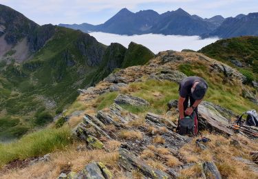
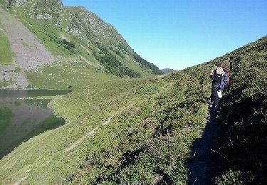
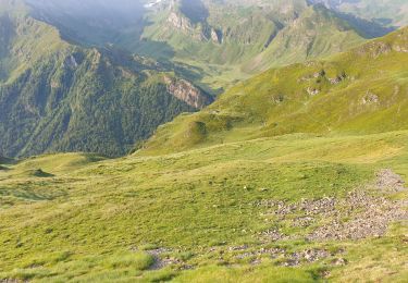
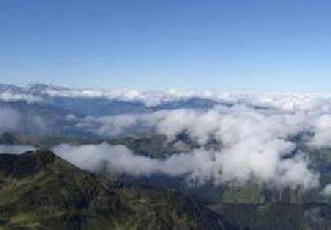
Du Hautacam au lac Vert Ilhéous darré Dabantaygue Distance 21.4 km - Denivelé 1850m Belle balade qui passe par 3 lacs : Ourrec, Bleu et Vert. C'est une alternative au départ du Chiroulet. Au départ, 2 endroits où il faut faire attention à 500 m : prendre le chemin du haut, celui du bas va vers le lac d'Isaby ... pas de marque. à 2600 m : là encore, prendre le chemin du haut (cairns) celui du bas, mieux marqué, va vers Couey-Sèque. On est au pied de la cabane d'Ouscouaou. Le chemin qui mène au lac d'Ourrec est facile à suivre. Pas de marque. Par contre quand on arrive au lac et qu'on traverse le ruisseau un peu derrière la cabane, il y a une marque indiquant la direction du col de Bareilles sur un rocher, et après le chemin est marqué jaune jusqu'au lac Bleu. Simplement après un petit pont en traverses, il est un peu difficile à suivre, mais on le retrouve facilement dans le col. Bareilles est court et raide, mais pas méchant. Descendez jusqu'au lac et au chemin qui en fait le tour, c'est agréable. Il y a des croix jaunes quand c'est nécessaire, les marques sont récentes. Le lac vert est facile à trouver lui aussi. Vous pouvez revenir par le même chemin, mais aussi par celui qui passe par la cabane de la Thoue. On voit bien la cabane au retour. Il est peu marqué, et sans qu'il soit impressionnant il vaut mieux avoir le pied sûr. Une autre branche passe par des rochers et arrive directement au col. Pour le reste il n'y a guère d'alternative, sauf à tenter le passage du lac d'Ourrec au lac de Couey-Sèque.
Ort
Kommentare
Touren in der Umgebung
![Tour Wandern Beaucens - Lac d'Ourrec depuis Hautacam - Photo](https://media.geolcdn.com/t/375/260/9579242b-e736-4d3c-b90a-ab67e4e2e4a3.jpg&format=jpg&maxdim=2)
![Wandern Wandern](https://static1.geolcdn.com/sitytour/trail-icons/101.png)
Wandern
![](/images/other/stat-length.png)
![](https://static1.geolcdn.com/siteimages/upload/files/16400158638029165_repeat_loop_refresh_sync_direction_icon.png)
![Tour Wandern Gazost - Pic de Montaigu par le Col de Moulata - Photo](https://media.geolcdn.com/t/375/260/ext.jpg?maxdim=2&url=https%3A%2F%2Fservices.sitytrail.com%2FGeolivesWS%2FDownloadMedia.ashx%3FTrailID%3D101300%26Media%3D795_1.jpg)
![Wandern Wandern](https://static1.geolcdn.com/sitytour/trail-icons/101.png)
Wandern
![](/images/other/stat-length.png)
![](https://static1.geolcdn.com/siteimages/upload/files/16400158638029165_repeat_loop_refresh_sync_direction_icon.png)
![Tour Wandern Beaucens - HAUTACAM lac dets plagnous](https://media.geolcdn.com/t/375/260/055be12c-65c3-4338-a853-a56ec08a55ad.jpg&format=jpg&maxdim=2)
![Wandern Wandern](https://static1.geolcdn.com/sitytour/trail-icons/101.png)
Wandern
![](/images/other/stat-length.png)
![](https://static1.geolcdn.com/siteimages/upload/files/16400158638029165_repeat_loop_refresh_sync_direction_icon.png)
![Tour Wandern Beaucens - 2019-07-31_15h54m36_20190731065058-08125-data - Photo](https://media.geolcdn.com/t/375/260/00c94413-6b1e-4202-b61c-baed3646c0bf.jpg&format=jpg&maxdim=2)
![Wandern Wandern](https://static1.geolcdn.com/sitytour/trail-icons/101.png)
Wandern
![](/images/other/stat-length.png)
![](https://static1.geolcdn.com/siteimages/upload/files/16400158638029165_repeat_loop_refresh_sync_direction_icon.png)
![Tour Wandern Beaucens - soum de lascours aléas bis - Photo](https://media.geolcdn.com/t/375/260/ext.jpg?maxdim=2&url=https%3A%2F%2Fservices.sitytrail.com%2FGeolivesWS%2FDownloadMedia.ashx%3FTrailID%3D140906%26Media%3D20120717091500.jpeg)
![Wandern Wandern](https://static1.geolcdn.com/sitytour/trail-icons/101.png)
Wandern
![](/images/other/stat-length.png)
![](https://static1.geolcdn.com/siteimages/upload/files/16400158638029165_repeat_loop_refresh_sync_direction_icon.png)
![Tour Wandern Beaucens - Retour voiture 28 juin 2023 hautacam - Photo](https://media.geolcdn.com/t/375/260/7561a025-8206-4fa3-858a-efbfd31b3c91.jpg&format=jpg&maxdim=2)
![Wandern Wandern](https://static1.geolcdn.com/sitytour/trail-icons/101.png)
Wandern
![](/images/other/stat-length.png)
![](https://static1.geolcdn.com/siteimages/upload/files/16400158638029165_repeat_loop_refresh_sync_direction_icon.png)
![Tour Schneeschuhwandern Beaucens - Le Pic du Mont - Hautacam - Photo](https://media.geolcdn.com/t/375/260/ext.jpg?maxdim=2&url=https%3A%2F%2Fservices.sitytrail.com%2FGeolivesWS%2FDownloadMedia.ashx%3FTrailID%3D317292%26Media%3D16484_6.jpg)
![Schneeschuhwandern Schneeschuhwandern](https://static1.geolcdn.com/sitytour/trail-icons/504.png)
Schneeschuhwandern
![](/images/other/stat-length.png)
![](https://static1.geolcdn.com/siteimages/upload/files/16400158638029165_repeat_loop_refresh_sync_direction_icon.png)
![Tour Wandern Beaucens - Le Pic de Montaigu par les crêtes - Beaucens - Photo](https://media.geolcdn.com/t/375/260/ext.jpg?maxdim=2&url=https%3A%2F%2Fservices.sitytrail.com%2FGeolivesWS%2FDownloadMedia.ashx%3FTrailID%3D316945%26Media%3D16057_6.jpg)
![Wandern Wandern](https://static1.geolcdn.com/sitytour/trail-icons/101.png)
Wandern
![](/images/other/stat-length.png)
![](https://static1.geolcdn.com/siteimages/upload/files/16400158638029165_repeat_loop_refresh_sync_direction_icon.png)
![Tour Schneeschuhwandern Beaucens - hautacam - Photo](https://media.geolcdn.com/t/375/260/ext.jpg?maxdim=2&url=https%3A%2F%2Fservices.sitytrail.com%2FGeolivesWS%2FDownloadMedia.ashx%3FTrailID%3D237498%26Media%3Dfix__20131215113911.jpg)
![Schneeschuhwandern Schneeschuhwandern](https://static1.geolcdn.com/sitytour/trail-icons/504.png)
Schneeschuhwandern
![](/images/other/stat-length.png)
![](https://static1.geolcdn.com/siteimages/upload/files/16400158638029165_repeat_loop_refresh_sync_direction_icon.png)