![](/images/other/stat-length.png)
![Tour Mountainbike Les Vigneaux - Espace VTT FFC Pays des Ecrins - Circuit n°06 - Le Grand Parcher - Photo](https://media.geolcdn.com/t/1900/400/ext.pjpeg?maxdim=2&url=https%3A%2F%2Fservices.sitytrail.com%2FGeolivesWS%2FDownloadMedia.ashx%3FTrailID%3D102514%26Media%3D3323_1.jpg)
Espace VTT FFC Pays des Ecrins - Circuit n°06 - Le Grand Parcher
tracegps
Benutzer
![Länge](/images/other/stat-length.png)
Länge
6,9 km
![Maximale Höhe](https://static1.geolcdn.com/siteimages/upload/files/1508320355ic_sort_altitude_max_24dp.png)
Maximale Höhe
1273 m
![Positive Höhendifferenz](https://static1.geolcdn.com/siteimages/upload/files/1508320355ic_sort_den_pos_24dp.png)
Positive Höhendifferenz
258 m
![Km-Effort](/images/other/stat-length.png)
Km-Effort
10,3 km
![Min. Höhe](https://static1.geolcdn.com/siteimages/upload/files/1508320355ic_sort_altitude_min_24dp.png)
Min. Höhe
1079 m
![Negative Höhendifferenz](https://static1.geolcdn.com/siteimages/upload/files/1508320355ic_sort_den_neg_24dp.png)
Negative Höhendifferenz
250 m
![Boucle](https://static1.geolcdn.com/siteimages/upload/files/16400158638029165_repeat_loop_refresh_sync_direction_icon.png)
Boucle
Ja
Erstellungsdatum :
2014-12-10 00:00:00.0
Letzte Änderung :
2014-12-10 00:00:00.0
![Mountainbike](https://static1.geolcdn.com/sitytour/trail-icons/202.png)
30m
Schwierigkeit : Schwierig
![Scannen Sie diesen QR-Code, um die Tour in der SityTrail-Anwendung zu öffnen](https://capi.geolives.com/qq0zvz2zws4bq2lad0pu/sitytour/trails/102514/qr.png?size=200)
Kostenlosegpshiking-Anwendung
Über SityTrail
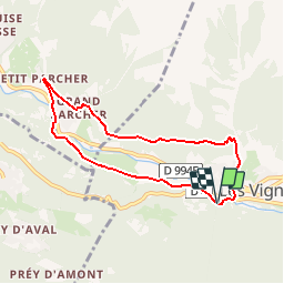
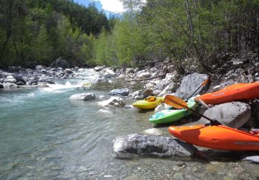
Tour Mountainbike von 6,9 km verfügbar auf Provence-Alpes-Côte d'Azur, Hochalpen, Les Vigneaux. Diese Tour wird von tracegps vorgeschlagen.
Beschreibung
Espace VTT FFC Pays des Ecrins Circuit labellisé par la Fédération Française de Cyclisme. Espace VTT FFC Pays des Ecrins – Circuit n°06 - Le Grand Parcher Téléchargez le Topo Guide des circuits VTT FFC du Pays des Ecrins.
Ort
Land:
France
Region :
Provence-Alpes-Côte d'Azur
Abteilung/Provinz :
Hochalpen
Kommune :
Les Vigneaux
Standort:
Unknown
Gehen Sie:(Dec)
Gehen Sie:(UTM)
305041 ; 4966149 (32T) N.
Kommentare
Touren in der Umgebung
![Tour Wandern Puy-Saint-Vincent - La tête d'Oreac - Photo](https://media.geolcdn.com/t/375/260/174c5726-c513-49d1-a693-65730cdb6179.jpg&format=jpg&maxdim=2)
![Wandern Wandern](https://static1.geolcdn.com/sitytour/trail-icons/101.png)
La tête d'Oreac
Wandern
Einfach
(2)
Puy-Saint-Vincent,
Provence-Alpes-Côte d'Azur,
Hochalpen,
France
![](/images/other/stat-length.png)
6 km | 10,4 km-effort
3h 55min
![](https://static1.geolcdn.com/siteimages/upload/files/16400158638029165_repeat_loop_refresh_sync_direction_icon.png)
Ja
![Tour Wandern Puy-Saint-Vincent - Cascades de Narreyroux - Puy Saint Vincent - Photo](https://media.geolcdn.com/t/375/260/ext.jpg?maxdim=2&url=https%3A%2F%2Fservices.sitytrail.com%2FGeolivesWS%2FDownloadMedia.ashx%3FTrailID%3D215154%26Media%3D15749_4.jpg)
![Wandern Wandern](https://static1.geolcdn.com/sitytour/trail-icons/101.png)
Cascades de Narreyroux - Puy Saint Vincent
Wandern
Schwierig
(1)
Puy-Saint-Vincent,
Provence-Alpes-Côte d'Azur,
Hochalpen,
France
![](/images/other/stat-length.png)
11,4 km | 19,2 km-effort
4h 0min
![](https://static1.geolcdn.com/siteimages/upload/files/16400158638029165_repeat_loop_refresh_sync_direction_icon.png)
Ja
![Tour Zu Fuß Vallouise-Pelvoux - Boucle vers Puy Aillaud - Photo](https://media.geolcdn.com/t/375/260/eef3011a-32af-4790-a416-25706592918e.jpeg&format=jpg&maxdim=2)
![Zu Fuß Zu Fuß](https://static1.geolcdn.com/sitytour/trail-icons/100.png)
Boucle vers Puy Aillaud
Zu Fuß
Einfach
Vallouise-Pelvoux,
Provence-Alpes-Côte d'Azur,
Hochalpen,
France
![](/images/other/stat-length.png)
5,3 km | 10,2 km-effort
2h 19min
![](https://static1.geolcdn.com/siteimages/upload/files/16400158638029165_repeat_loop_refresh_sync_direction_icon.png)
Nein
![Tour Zu Fuß Vallouise-Pelvoux - Boucle de Pelvoux - Photo](https://media.geolcdn.com/t/375/260/5ff99f02-24ff-4116-85ce-efee1281dc27.jpeg&format=jpg&maxdim=2)
![Zu Fuß Zu Fuß](https://static1.geolcdn.com/sitytour/trail-icons/100.png)
Boucle de Pelvoux
Zu Fuß
Einfach
Vallouise-Pelvoux,
Provence-Alpes-Côte d'Azur,
Hochalpen,
France
![](/images/other/stat-length.png)
12,2 km | 18,7 km-effort
4h 15min
![](https://static1.geolcdn.com/siteimages/upload/files/16400158638029165_repeat_loop_refresh_sync_direction_icon.png)
Ja
![Tour Zu Fuß Vallouise-Pelvoux - Boucle de Vallouise - Photo](https://media.geolcdn.com/t/375/260/d4c61dbc-be31-4372-8648-4be9dfe9a2a3.jpeg&format=jpg&maxdim=2)
![Zu Fuß Zu Fuß](https://static1.geolcdn.com/sitytour/trail-icons/100.png)
Boucle de Vallouise
Zu Fuß
Einfach
Vallouise-Pelvoux,
Provence-Alpes-Côte d'Azur,
Hochalpen,
France
![](/images/other/stat-length.png)
8,1 km | 11,6 km-effort
2h 38min
![](https://static1.geolcdn.com/siteimages/upload/files/16400158638029165_repeat_loop_refresh_sync_direction_icon.png)
Ja
![Tour Zu Fuß Les Vigneaux - Tour des Vigneaux - Photo](https://media.geolcdn.com/t/375/260/fd3b5f61-26ba-4d1e-9af2-366d68bf8117.jpeg&format=jpg&maxdim=2)
![Zu Fuß Zu Fuß](https://static1.geolcdn.com/sitytour/trail-icons/100.png)
Tour des Vigneaux
Zu Fuß
Einfach
Les Vigneaux,
Provence-Alpes-Côte d'Azur,
Hochalpen,
France
![](/images/other/stat-length.png)
5,7 km | 7,5 km-effort
1h 42min
![](https://static1.geolcdn.com/siteimages/upload/files/16400158638029165_repeat_loop_refresh_sync_direction_icon.png)
Ja
![Tour Schneeschuhwandern Puy-Saint-Vincent - la tête d'Oréac - Photo](https://media.geolcdn.com/t/375/260/f97877d2-86be-4ba2-b92e-863cfeff071e.jpg&format=jpg&maxdim=2)
![Schneeschuhwandern Schneeschuhwandern](https://static1.geolcdn.com/sitytour/trail-icons/504.png)
la tête d'Oréac
Schneeschuhwandern
Medium
Puy-Saint-Vincent,
Provence-Alpes-Côte d'Azur,
Hochalpen,
France
![](/images/other/stat-length.png)
6,4 km | 11,4 km-effort
4h 7min
![](https://static1.geolcdn.com/siteimages/upload/files/16400158638029165_repeat_loop_refresh_sync_direction_icon.png)
Ja
![Tour Wandern Puy-Saint-Vincent - le lac des Hermes - Photo](https://media.geolcdn.com/t/375/260/ext.jpg?maxdim=2&url=https%3A%2F%2Fservices.sitytrail.com%2FGeolivesWS%2FDownloadMedia.ashx%3FTrailID%3D731563%26Media%3Dfix__20170411163111.jpg)
![Wandern Wandern](https://static1.geolcdn.com/sitytour/trail-icons/101.png)
le lac des Hermes
Wandern
Einfach
Puy-Saint-Vincent,
Provence-Alpes-Côte d'Azur,
Hochalpen,
France
![](/images/other/stat-length.png)
4,3 km | 6,5 km-effort
3h 9min
![](https://static1.geolcdn.com/siteimages/upload/files/16400158638029165_repeat_loop_refresh_sync_direction_icon.png)
Ja
![Tour Wandern Puy-Saint-Vincent - Narreyroux au départ de PSV 1600 - Photo](https://media.geolcdn.com/t/375/260/ext.jpg?maxdim=2&url=https%3A%2F%2Fservices.sitytrail.com%2FGeolivesWS%2FDownloadMedia.ashx%3FTrailID%3D731450%26Media%3Dfix__20170412153459.jpg)
![Wandern Wandern](https://static1.geolcdn.com/sitytour/trail-icons/101.png)
Narreyroux au départ de PSV 1600
Wandern
Sehr leicht
Puy-Saint-Vincent,
Provence-Alpes-Côte d'Azur,
Hochalpen,
France
![](/images/other/stat-length.png)
4,6 km | 6,3 km-effort
1h 49min
![](https://static1.geolcdn.com/siteimages/upload/files/16400158638029165_repeat_loop_refresh_sync_direction_icon.png)
Ja