![](/images/other/stat-length.png)
![Tour Fahrrad Propriano - Ajaccio --> Bonifacio - Etape 4 - Photo](https://media.geolcdn.com/t/1900/400/ext.pjpeg?maxdim=2&url=https%3A%2F%2Fstatic1.geolcdn.com%2Fsiteimages%2Fupload%2Ffiles%2F1524743154velo.jpg)
Ajaccio --> Bonifacio - Etape 4
tracegps
Benutzer
![Länge](/images/other/stat-length.png)
![Maximale Höhe](https://static1.geolcdn.com/siteimages/upload/files/1508320355ic_sort_altitude_max_24dp.png)
![Positive Höhendifferenz](https://static1.geolcdn.com/siteimages/upload/files/1508320355ic_sort_den_pos_24dp.png)
![Km-Effort](/images/other/stat-length.png)
![Min. Höhe](https://static1.geolcdn.com/siteimages/upload/files/1508320355ic_sort_altitude_min_24dp.png)
![Negative Höhendifferenz](https://static1.geolcdn.com/siteimages/upload/files/1508320355ic_sort_den_neg_24dp.png)
![Boucle](https://static1.geolcdn.com/siteimages/upload/files/16400158638029165_repeat_loop_refresh_sync_direction_icon.png)
![Fahrrad](https://static1.geolcdn.com/sitytour/trail-icons/200.png)
4h00
Schwierigkeit : Schwierig
![Scannen Sie diesen QR-Code, um die Tour in der SityTrail-Anwendung zu öffnen](https://capi.geolives.com/qq0zvz2zws4bq2lad0pu/sitytour/trails/102452/qr.png?size=200)
Kostenlosegpshiking-Anwendung
Über SityTrail
Tour Fahrrad von 30 km verfügbar auf Korsika, Südkorsika, Propriano. Diese Tour wird von tracegps vorgeschlagen.
Beschreibung
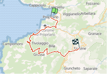
** Etape 4 - Propriano --> Sartène ** Longueur cartographique = 30,199 Km Circuit de 158Km utilisant dans la mesure du possible des voies secondaires carrossables dans des paysages côtiers et montagneux superbes. Les 5 étapes sont à titre indicatifs et sont modulables en fonction du physique et des hébergements. Les autres étapes : ** Etape 1 - Ajaccio --> Portigliolo ** Longueur cartographique = 33,288 Km ** Etape 2 - Portigliolo --> Serra-di-Ferro ** Longueur cartographique = 23,259 Km ** Etape 3 - Serra-di-Ferro --> Propriano ** Longueur cartographique = 20,094 Km ** Etape 5 - Sartène --> Bonifacio ** Longueur cartographique = 51,526 Km
Ort
Kommentare
Touren in der Umgebung
![Tour Wandern Olmeto - Mare e Monti Sud - De Olmeto à Burgo - Photo](https://media.geolcdn.com/t/375/260/ext.jpg?maxdim=2&url=https%3A%2F%2Fservices.sitytrail.com%2FGeolivesWS%2FDownloadMedia.ashx%3FTrailID%3D109321%26Media%3D3576_1.jpg)
![Wandern Wandern](https://static1.geolcdn.com/sitytour/trail-icons/101.png)
Wandern
![](/images/other/stat-length.png)
![](https://static1.geolcdn.com/siteimages/upload/files/16400158638029165_repeat_loop_refresh_sync_direction_icon.png)
![Tour Wandern Propriano - Visite découverte Propriano - Photo](https://media.geolcdn.com/t/375/260/e3d06ee6-dd7a-4e60-9d13-47793cf35a90.jpg&format=jpg&maxdim=2)
![Wandern Wandern](https://static1.geolcdn.com/sitytour/trail-icons/101.png)
Wandern
![](/images/other/stat-length.png)
![](https://static1.geolcdn.com/siteimages/upload/files/16400158638029165_repeat_loop_refresh_sync_direction_icon.png)
![Tour Wandern Propriano - Circuit de Paratella - Photo](https://media.geolcdn.com/t/375/260/ext.jpg?maxdim=2&url=https%3A%2F%2Fstatic1.geolcdn.com%2Fsiteimages%2Fupload%2Ffiles%2F1553511878bg_sport_marche.png)
![Wandern Wandern](https://static1.geolcdn.com/sitytour/trail-icons/101.png)
Wandern
![](/images/other/stat-length.png)
![](https://static1.geolcdn.com/siteimages/upload/files/16400158638029165_repeat_loop_refresh_sync_direction_icon.png)
![Tour Wandern Olmeto - Monte Barbatu - Photo](https://media.geolcdn.com/t/375/260/ext.jpg?maxdim=2&url=https%3A%2F%2Fstatic1.geolcdn.com%2Fsiteimages%2Fupload%2Ffiles%2F1553511878bg_sport_marche.png)
![Wandern Wandern](https://static1.geolcdn.com/sitytour/trail-icons/101.png)
Wandern
![](/images/other/stat-length.png)
![](https://static1.geolcdn.com/siteimages/upload/files/16400158638029165_repeat_loop_refresh_sync_direction_icon.png)
![Tour Elektrofahrrad Olmeto - Barrontia - Photo](https://media.geolcdn.com/t/375/260/e2f78268-ee53-4fed-ab36-e31fbdf34bf2.jpg&format=jpg&maxdim=2)
![Elektrofahrrad Elektrofahrrad](https://static1.geolcdn.com/sitytour/trail-icons/205.png)
Elektrofahrrad
![](/images/other/stat-length.png)
![](https://static1.geolcdn.com/siteimages/upload/files/16400158638029165_repeat_loop_refresh_sync_direction_icon.png)
![Tour Wandern Olmeto - C7 Mare e Monti Sud: Olmeto - Porto Polo - Photo](https://media.geolcdn.com/t/375/260/ext.jpg?maxdim=2&url=https%3A%2F%2Fservices.sitytrail.com%2FGeolivesWS%2FDownloadMedia.ashx%3FTrailID%3D980251%26Media%3Dfix__20180530134509.jpg)
![Wandern Wandern](https://static1.geolcdn.com/sitytour/trail-icons/101.png)
Wandern
![](/images/other/stat-length.png)
![](https://static1.geolcdn.com/siteimages/upload/files/16400158638029165_repeat_loop_refresh_sync_direction_icon.png)
![Tour Wandern Olmeto - Olmeto - Propriano - Photo](https://media.geolcdn.com/t/375/260/e08eaf3b-9337-4ebb-a921-618ef9a00faf.jpg&format=jpg&maxdim=2)
![Wandern Wandern](https://static1.geolcdn.com/sitytour/trail-icons/101.png)
Wandern
![](/images/other/stat-length.png)
![](https://static1.geolcdn.com/siteimages/upload/files/16400158638029165_repeat_loop_refresh_sync_direction_icon.png)
![Tour Segelboot Propriano - lion de rocofar1 - Photo](https://media.geolcdn.com/t/375/260/98f75a34-0aac-4256-93f3-7a771324fc24.jpg&format=jpg&maxdim=2)
![Segelboot Segelboot](https://static1.geolcdn.com/sitytour/trail-icons/702.png)
Segelboot
![](/images/other/stat-length.png)
![](https://static1.geolcdn.com/siteimages/upload/files/16400158638029165_repeat_loop_refresh_sync_direction_icon.png)
![Tour Wandern Propriano - Belambra-Cap Laurenzu- Paratelle - Photo](https://media.geolcdn.com/t/375/260/a867e8aa-daba-4ccb-ba73-e5e509877048.jpg&format=jpg&maxdim=2)
![Wandern Wandern](https://static1.geolcdn.com/sitytour/trail-icons/101.png)
Wandern
![](/images/other/stat-length.png)
![](https://static1.geolcdn.com/siteimages/upload/files/16400158638029165_repeat_loop_refresh_sync_direction_icon.png)