![](/images/other/stat-length.png)
![Tour Mountainbike Éclaron-Braucourt-Sainte-Livière - Espace VTT FFC Lac du Der en Champagne - Circuit n°08 - La Forêt du Der - Photo](https://media.geolcdn.com/t/1900/400/ext.pjpeg?maxdim=2&url=https%3A%2F%2Fservices.sitytrail.com%2FGeolivesWS%2FDownloadMedia.ashx%3FTrailID%3D102269%26Media%3D2730_1.jpg)
Espace VTT FFC Lac du Der en Champagne - Circuit n°08 - La Forêt du Der
tracegps
Benutzer
![Länge](/images/other/stat-length.png)
Länge
19,5 km
![Maximale Höhe](https://static1.geolcdn.com/siteimages/upload/files/1508320355ic_sort_altitude_max_24dp.png)
Maximale Höhe
180 m
![Positive Höhendifferenz](https://static1.geolcdn.com/siteimages/upload/files/1508320355ic_sort_den_pos_24dp.png)
Positive Höhendifferenz
223 m
![Km-Effort](/images/other/stat-length.png)
Km-Effort
22 km
![Min. Höhe](https://static1.geolcdn.com/siteimages/upload/files/1508320355ic_sort_altitude_min_24dp.png)
Min. Höhe
139 m
![Negative Höhendifferenz](https://static1.geolcdn.com/siteimages/upload/files/1508320355ic_sort_den_neg_24dp.png)
Negative Höhendifferenz
223 m
![Boucle](https://static1.geolcdn.com/siteimages/upload/files/16400158638029165_repeat_loop_refresh_sync_direction_icon.png)
Boucle
Ja
Erstellungsdatum :
2014-12-10 00:00:00.0
Letzte Änderung :
2014-12-10 00:00:00.0
![Mountainbike](https://static1.geolcdn.com/sitytour/trail-icons/202.png)
1h30
Schwierigkeit : Medium
![Scannen Sie diesen QR-Code, um die Tour in der SityTrail-Anwendung zu öffnen](https://capi.geolives.com/qq0zvz2zws4bq2lad0pu/sitytour/trails/102269/qr.png?size=200)
Kostenlosegpshiking-Anwendung
Über SityTrail
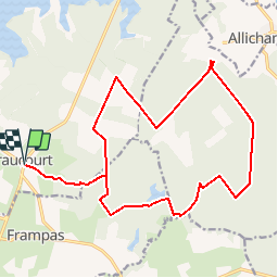
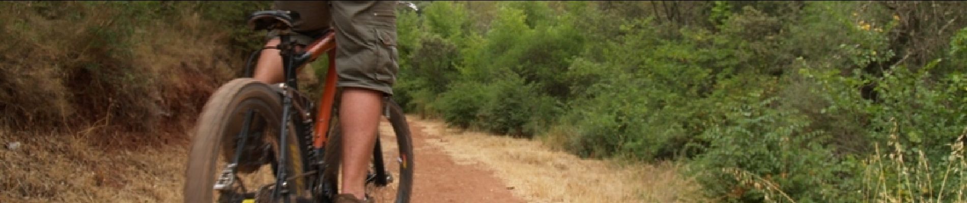
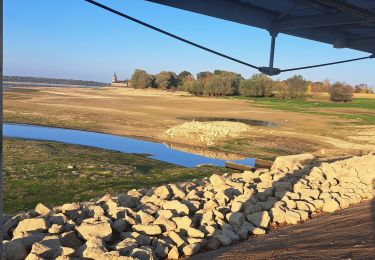
Tour Mountainbike von 19,5 km verfügbar auf Großer Osten, Haute-Marne, Éclaron-Braucourt-Sainte-Livière. Diese Tour wird von tracegps vorgeschlagen.
Beschreibung
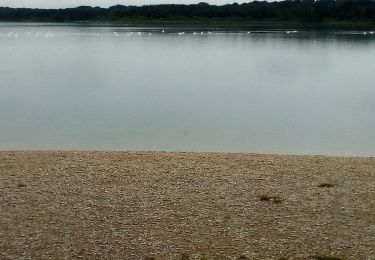
Espace VTT - FFC Lac du Der en Champagne Circuit officiel labellisé par la Fédération Française de Cyclisme. Idéal en VTT, ce circuit vous emmène dans la belle forêt du Der alternant grandes routes forestières et petits layons.
Ort
Land:
France
Region :
Großer Osten
Abteilung/Provinz :
Haute-Marne
Kommune :
Éclaron-Braucourt-Sainte-Livière
Standort:
Braucourt
Gehen Sie:(Dec)
Gehen Sie:(UTM)
634164 ; 5377249 (31U) N.
Kommentare
Touren in der Umgebung
![Tour Mountainbike Éclaron-Braucourt-Sainte-Livière - Tour du lac du Der - Photo](https://media.geolcdn.com/t/375/260/ext.jpg?maxdim=2&url=https%3A%2F%2Fstatic1.geolcdn.com%2Fsiteimages%2Fupload%2Ffiles%2F1524743154velo.jpg)
![Mountainbike Mountainbike](https://static1.geolcdn.com/sitytour/trail-icons/202.png)
Tour du lac du Der
Mountainbike
Medium
(1)
Éclaron-Braucourt-Sainte-Livière,
Großer Osten,
Haute-Marne,
France
![](/images/other/stat-length.png)
36 km | 39 km-effort
2h 0min
![](https://static1.geolcdn.com/siteimages/upload/files/16400158638029165_repeat_loop_refresh_sync_direction_icon.png)
Ja
![Tour Wandern Giffaumont-Champaubert - LAC dur DER ... la forêt, la terre et l'eau. - Photo](https://media.geolcdn.com/t/375/260/16ddca7d-e5a5-4726-a093-703886190c99.jpg&format=jpg&maxdim=2)
![Wandern Wandern](https://static1.geolcdn.com/sitytour/trail-icons/101.png)
LAC dur DER ... la forêt, la terre et l'eau.
Wandern
Sehr leicht
Giffaumont-Champaubert,
Großer Osten,
Marne,
France
![](/images/other/stat-length.png)
13,5 km | 14,9 km-effort
3h 32min
![](https://static1.geolcdn.com/siteimages/upload/files/16400158638029165_repeat_loop_refresh_sync_direction_icon.png)
Ja
![Tour Mountainbike Éclaron-Braucourt-Sainte-Livière - Lac du DER - CHANTECOQ ... par St-Marie- Nuisement. - Photo](https://media.geolcdn.com/t/375/260/0f27a926-3a1d-4ecb-8e04-b7fa88246190.jpg&format=jpg&maxdim=2)
![Mountainbike Mountainbike](https://static1.geolcdn.com/sitytour/trail-icons/202.png)
Lac du DER - CHANTECOQ ... par St-Marie- Nuisement.
Mountainbike
Sehr leicht
Éclaron-Braucourt-Sainte-Livière,
Großer Osten,
Haute-Marne,
France
![](/images/other/stat-length.png)
37 km | 40 km-effort
3h 13min
![](https://static1.geolcdn.com/siteimages/upload/files/16400158638029165_repeat_loop_refresh_sync_direction_icon.png)
Ja
![Tour Wandern Giffaumont-Champaubert - ghifaumont - Photo](https://media.geolcdn.com/t/375/260/2d20b284-5919-43bc-beca-9c34719666bc.jpg&format=jpg&maxdim=2)
![Wandern Wandern](https://static1.geolcdn.com/sitytour/trail-icons/101.png)
ghifaumont
Wandern
Sehr leicht
Giffaumont-Champaubert,
Großer Osten,
Marne,
France
![](/images/other/stat-length.png)
12,3 km | 13,8 km-effort
2h 48min
![](https://static1.geolcdn.com/siteimages/upload/files/16400158638029165_repeat_loop_refresh_sync_direction_icon.png)
Nein
![Tour Wandern Giffaumont-Champaubert - Lac du Der 09-04-2014 - Photo](https://media.geolcdn.com/t/375/260/ext.jpg?maxdim=2&url=https%3A%2F%2Fstatic1.geolcdn.com%2Fsiteimages%2Fupload%2Ffiles%2F1553511878bg_sport_marche.png)
![Wandern Wandern](https://static1.geolcdn.com/sitytour/trail-icons/101.png)
Lac du Der 09-04-2014
Wandern
Sehr leicht
(1)
Giffaumont-Champaubert,
Großer Osten,
Marne,
France
![](/images/other/stat-length.png)
12,7 km | 14 km-effort
2h 59min
![](https://static1.geolcdn.com/siteimages/upload/files/16400158638029165_repeat_loop_refresh_sync_direction_icon.png)
Ja
![Tour Wandern Giffaumont-Champaubert - lac du der - Photo](https://media.geolcdn.com/t/375/260/a2a32ad6-c50c-4066-848f-0c39f2554faa.jpg&format=jpg&maxdim=2)
![Wandern Wandern](https://static1.geolcdn.com/sitytour/trail-icons/101.png)
lac du der
Wandern
Einfach
Giffaumont-Champaubert,
Großer Osten,
Marne,
France
![](/images/other/stat-length.png)
5 km | 5,5 km-effort
2h 7min
![](https://static1.geolcdn.com/siteimages/upload/files/16400158638029165_repeat_loop_refresh_sync_direction_icon.png)
Ja
![Tour Wandern Éclaron-Braucourt-Sainte-Livière - Le Det - Photo](https://media.geolcdn.com/t/375/260/7940e994-1b3c-4570-948d-a615323b8e15.jpg&format=jpg&maxdim=2)
![Wandern Wandern](https://static1.geolcdn.com/sitytour/trail-icons/101.png)
Le Det
Wandern
Schwierig
Éclaron-Braucourt-Sainte-Livière,
Großer Osten,
Haute-Marne,
France
![](/images/other/stat-length.png)
12,4 km | 13,5 km-effort
2h 40min
![](https://static1.geolcdn.com/siteimages/upload/files/16400158638029165_repeat_loop_refresh_sync_direction_icon.png)
Ja
![Tour Wandern Giffaumont-Champaubert - der - Photo](https://media.geolcdn.com/t/375/260/f606a1ab-40e5-4229-8eaa-6f24ec9a7d96.jpg&format=jpg&maxdim=2)
![Wandern Wandern](https://static1.geolcdn.com/sitytour/trail-icons/101.png)
der
Wandern
Einfach
Giffaumont-Champaubert,
Großer Osten,
Marne,
France
![](/images/other/stat-length.png)
3,6 km | 4 km-effort
1h 26min
![](https://static1.geolcdn.com/siteimages/upload/files/16400158638029165_repeat_loop_refresh_sync_direction_icon.png)
Ja
![Tour Mountainbike Giffaumont-Champaubert - Espace VTT FFC Lac du Der en Champagne - Circuit n°01 - Entre Dame et Chevalier - Photo](https://media.geolcdn.com/t/375/260/ext.jpg?maxdim=2&url=https%3A%2F%2Fservices.sitytrail.com%2FGeolivesWS%2FDownloadMedia.ashx%3FTrailID%3D102260%26Media%3D2721_1.jpg)
![Mountainbike Mountainbike](https://static1.geolcdn.com/sitytour/trail-icons/202.png)
Espace VTT FFC Lac du Der en Champagne - Circuit n°01 - Entre Dame et Chevalier
Mountainbike
Medium
Giffaumont-Champaubert,
Großer Osten,
Marne,
France
![](/images/other/stat-length.png)
11,2 km | 12,3 km-effort
1h 0min
![](https://static1.geolcdn.com/siteimages/upload/files/16400158638029165_repeat_loop_refresh_sync_direction_icon.png)
Ja