![](/images/other/stat-length.png)
![Tour Mountainbike Saint-Nazaire-le-Désert - Grande Traversée des PréAlpes à VTT : Saint Nazaire le Désert - La Motte Chalancon - Photo](https://media.geolcdn.com/t/1900/400/ext.pjpeg?maxdim=2&url=https%3A%2F%2Fservices.sitytrail.com%2FGeolivesWS%2FDownloadMedia.ashx%3FTrailID%3D102175%26Media%3D2566_2.jpg)
Grande Traversée des PréAlpes à VTT : Saint Nazaire le Désert - La Motte Chalancon
tracegps
Benutzer
![Länge](/images/other/stat-length.png)
![Maximale Höhe](https://static1.geolcdn.com/siteimages/upload/files/1508320355ic_sort_altitude_max_24dp.png)
![Positive Höhendifferenz](https://static1.geolcdn.com/siteimages/upload/files/1508320355ic_sort_den_pos_24dp.png)
![Km-Effort](/images/other/stat-length.png)
![Min. Höhe](https://static1.geolcdn.com/siteimages/upload/files/1508320355ic_sort_altitude_min_24dp.png)
![Negative Höhendifferenz](https://static1.geolcdn.com/siteimages/upload/files/1508320355ic_sort_den_neg_24dp.png)
![Boucle](https://static1.geolcdn.com/siteimages/upload/files/16400158638029165_repeat_loop_refresh_sync_direction_icon.png)
![Mountainbike](https://static1.geolcdn.com/sitytour/trail-icons/202.png)
2h49
Schwierigkeit : Sehr schwierig
![Scannen Sie diesen QR-Code, um die Tour in der SityTrail-Anwendung zu öffnen](https://capi.geolives.com/qq0zvz2zws4bq2lad0pu/sitytour/trails/102175/qr.png?size=200)
Kostenlosegpshiking-Anwendung
Über SityTrail
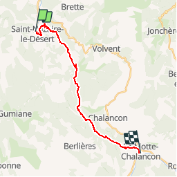
Tour Mountainbike von 18,9 km verfügbar auf Auvergne-Rhone-Alpen, Drôme, Saint-Nazaire-le-Désert. Diese Tour wird von tracegps vorgeschlagen.
Beschreibung
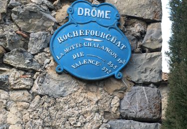
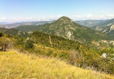
Grande Traversée des Préalpes, les Chemins du Soleil. Parcours officiel labellisé par la Fédération Française de Cyclisme. Variante sportive de Saillans à Montmorin. Parcours Saillans - Montmorin – Tronçon n° 40 Niveau: très difficile, avec quelques poussettes et plusieurs passages techniques. Mesure de prudence: sentier étroit et caillouteux avant la ferme Fébie (après le point 6), après le col du Buisson (point 10), dans la descente de la montagne de Longue Serre. Consultez toutes les informations sur les hébergements et les services associés sur la fiche du tronçon. Retrouvez cette traversée dans l’indispensable topo Guide Chamina Grande Traversée des Préalpes
Ort
Kommentare
Touren in der Umgebung
![Tour Wandern Saint-Nazaire-le-Désert - 26 st Nazaire le desert - Photo](https://media.geolcdn.com/t/375/260/800f793b-c8e6-438c-bf52-c0a833bbf3e1.jpg&format=jpg&maxdim=2)
![Wandern Wandern](https://static1.geolcdn.com/sitytour/trail-icons/101.png)
Wandern
![](/images/other/stat-length.png)
![](https://static1.geolcdn.com/siteimages/upload/files/16400158638029165_repeat_loop_refresh_sync_direction_icon.png)
![Tour Wandern Saint-Nazaire-le-Désert - Bergerie du Pradaux - Photo](https://media.geolcdn.com/t/375/260/ext.jpg?maxdim=2&url=https%3A%2F%2Fstatic1.geolcdn.com%2Fsiteimages%2Fupload%2Ffiles%2F1553511878bg_sport_marche.png)
![Wandern Wandern](https://static1.geolcdn.com/sitytour/trail-icons/101.png)
Wandern
![](/images/other/stat-length.png)
![](https://static1.geolcdn.com/siteimages/upload/files/16400158638029165_repeat_loop_refresh_sync_direction_icon.png)
![Tour Wandern Rochefourchat - Serre Délégué depuis Rochefourchat 15 10 23 - Photo](https://media.geolcdn.com/t/375/260/dd32defb-f16e-4dda-98b5-10da95afa891.jpg&format=jpg&maxdim=2)
![Wandern Wandern](https://static1.geolcdn.com/sitytour/trail-icons/101.png)
Wandern
![](/images/other/stat-length.png)
![](https://static1.geolcdn.com/siteimages/upload/files/16400158638029165_repeat_loop_refresh_sync_direction_icon.png)
![Tour Wandern Saint-Nazaire-le-Désert - Saint Nazaire le Désert - Photo](https://media.geolcdn.com/t/375/260/727e7242-c051-4080-9ece-fd964be15596.jpg&format=jpg&maxdim=2)
![Wandern Wandern](https://static1.geolcdn.com/sitytour/trail-icons/101.png)
Wandern
![](/images/other/stat-length.png)
![](https://static1.geolcdn.com/siteimages/upload/files/16400158638029165_repeat_loop_refresh_sync_direction_icon.png)
![Tour Wandern Rochefourchat - Grand Delmas depuis Rochefourchat - Photo](https://media.geolcdn.com/t/375/260/d54b38a2-4988-4640-bf17-e0e6b4ff0960.jpg&format=jpg&maxdim=2)
![Wandern Wandern](https://static1.geolcdn.com/sitytour/trail-icons/101.png)
Wandern
![](/images/other/stat-length.png)
![](https://static1.geolcdn.com/siteimages/upload/files/16400158638029165_repeat_loop_refresh_sync_direction_icon.png)
![Tour Wandern Saint-Nazaire-le-Désert - St Nazaire le Désert Bergerie des Pradaux - Photo](https://media.geolcdn.com/t/375/260/6e1323bf-526c-4599-aac0-2d5d88ff4402.jpg&format=jpg&maxdim=2)
![Wandern Wandern](https://static1.geolcdn.com/sitytour/trail-icons/101.png)
Wandern
![](/images/other/stat-length.png)
![](https://static1.geolcdn.com/siteimages/upload/files/16400158638029165_repeat_loop_refresh_sync_direction_icon.png)
![Tour Wandern Rochefourchat - Rochefourchat (ASPTT) - Photo](https://media.geolcdn.com/t/375/260/1fdac6b0-e9dc-4a61-aa39-771c68602c4b.jpg&format=jpg&maxdim=2)
![Wandern Wandern](https://static1.geolcdn.com/sitytour/trail-icons/101.png)
Wandern
![](/images/other/stat-length.png)
![](https://static1.geolcdn.com/siteimages/upload/files/16400158638029165_repeat_loop_refresh_sync_direction_icon.png)
![Wandern Wandern](https://static1.geolcdn.com/sitytour/trail-icons/101.png)
Wandern
![](/images/other/stat-length.png)
![](https://static1.geolcdn.com/siteimages/upload/files/16400158638029165_repeat_loop_refresh_sync_direction_icon.png)
![Tour Wandern Saint-Nazaire-le-Désert - st nazaire le desert-les pradaux - Photo](https://media.geolcdn.com/t/375/260/ext.jpg?maxdim=2&url=https%3A%2F%2Fservices.sitytrail.com%2FGeolivesWS%2FDownloadMedia.ashx%3FTrailID%3D214064%26Media%3D20130815152924.jpg)
![Wandern Wandern](https://static1.geolcdn.com/sitytour/trail-icons/101.png)
Wandern
![](/images/other/stat-length.png)
![](https://static1.geolcdn.com/siteimages/upload/files/16400158638029165_repeat_loop_refresh_sync_direction_icon.png)