![](/images/other/stat-length.png)
![Tour Mountainbike Saillans - Grande Traversée des PréAlpes à VTT : Saillans - La Chaudière - Photo](https://media.geolcdn.com/t/1900/400/ext.pjpeg?maxdim=2&url=https%3A%2F%2Fservices.sitytrail.com%2FGeolivesWS%2FDownloadMedia.ashx%3FTrailID%3D102173%26Media%3D2564_2.jpg)
Grande Traversée des PréAlpes à VTT : Saillans - La Chaudière
tracegps
Benutzer
![Länge](/images/other/stat-length.png)
![Maximale Höhe](https://static1.geolcdn.com/siteimages/upload/files/1508320355ic_sort_altitude_max_24dp.png)
![Positive Höhendifferenz](https://static1.geolcdn.com/siteimages/upload/files/1508320355ic_sort_den_pos_24dp.png)
![Km-Effort](/images/other/stat-length.png)
![Min. Höhe](https://static1.geolcdn.com/siteimages/upload/files/1508320355ic_sort_altitude_min_24dp.png)
![Negative Höhendifferenz](https://static1.geolcdn.com/siteimages/upload/files/1508320355ic_sort_den_neg_24dp.png)
![Boucle](https://static1.geolcdn.com/siteimages/upload/files/16400158638029165_repeat_loop_refresh_sync_direction_icon.png)
![Mountainbike](https://static1.geolcdn.com/sitytour/trail-icons/202.png)
1h30
Schwierigkeit : Schwierig
![Scannen Sie diesen QR-Code, um die Tour in der SityTrail-Anwendung zu öffnen](https://capi.geolives.com/qq0zvz2zws4bq2lad0pu/sitytour/trails/102173/qr.png?size=200)
Kostenlosegpshiking-Anwendung
Über SityTrail
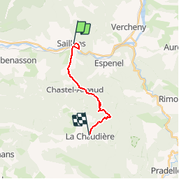
Tour Mountainbike von 12 km verfügbar auf Auvergne-Rhone-Alpen, Drôme, Saillans. Diese Tour wird von tracegps vorgeschlagen.
Beschreibung
Grande Traversée des Préalpes, les Chemins du Soleil. Parcours officiel labellisé par la Fédération Française de Cyclisme. Variante sportive de Saillans à Montmorin. Parcours Saillans - Montmorin – Tronçon n° 38 Niveau: difficile, itinéraire à profil montant. Longue portion de route au début, ensuite piste assez roulante. Mesure de prudence: sentier technique après le col du Hérison. Consultez toutes les informations sur les hébergements et les services associés sur la fiche du tronçon. Retrouvez cette traversée dans l’indispensable topo Guide Chamina Grande Traversée des Préalpes
Ort
Kommentare
Touren in der Umgebung
![Tour Wandern Saillans - Saillans Chapelle St Christophe 14km. - Photo](https://media.geolcdn.com/t/375/260/dbc3dc28-619e-4ea9-9959-103bf755836c.jpg&format=jpg&maxdim=2)
![Wandern Wandern](https://static1.geolcdn.com/sitytour/trail-icons/101.png)
Wandern
![](/images/other/stat-length.png)
![](https://static1.geolcdn.com/siteimages/upload/files/16400158638029165_repeat_loop_refresh_sync_direction_icon.png)
![Tour Wandern Vercheny - Vercheny Chateau du Barry 14 km - Photo](https://media.geolcdn.com/t/375/260/519ec2eb-eec0-4702-a29a-2c5cd69166ae.jpg&format=jpg&maxdim=2)
![Wandern Wandern](https://static1.geolcdn.com/sitytour/trail-icons/101.png)
Wandern
![](/images/other/stat-length.png)
![](https://static1.geolcdn.com/siteimages/upload/files/16400158638029165_repeat_loop_refresh_sync_direction_icon.png)
![Tour Mountainbike Saillans - Grande Traversée des PréAlpes à VTT : variante Saillans - Montmorin - Photo](https://media.geolcdn.com/t/375/260/ext.jpg?maxdim=2&url=https%3A%2F%2Fservices.sitytrail.com%2FGeolivesWS%2FDownloadMedia.ashx%3FTrailID%3D102178%26Media%3D2569_1.jpg)
![Mountainbike Mountainbike](https://static1.geolcdn.com/sitytour/trail-icons/202.png)
Mountainbike
![](/images/other/stat-length.png)
![](https://static1.geolcdn.com/siteimages/upload/files/16400158638029165_repeat_loop_refresh_sync_direction_icon.png)
![Tour Wandern Saillans - 26 gaudichard zel - Photo](https://media.geolcdn.com/t/375/260/b5e022d8-7c23-4271-85bc-1b741ca6ca0c.jpg&format=jpg&maxdim=2)
![Wandern Wandern](https://static1.geolcdn.com/sitytour/trail-icons/101.png)
Wandern
![](/images/other/stat-length.png)
![](https://static1.geolcdn.com/siteimages/upload/files/16400158638029165_repeat_loop_refresh_sync_direction_icon.png)
![Tour Wandern Saillans - 26 saillans gaudichard - Photo](https://media.geolcdn.com/t/375/260/1830d641-d56f-4240-ac55-b631a71b01c6.jpg&format=jpg&maxdim=2)
![Wandern Wandern](https://static1.geolcdn.com/sitytour/trail-icons/101.png)
Wandern
![](/images/other/stat-length.png)
![](https://static1.geolcdn.com/siteimages/upload/files/16400158638029165_repeat_loop_refresh_sync_direction_icon.png)
![Tour Wandern Chastel-Arnaud - montagne de Farraud - Photo](https://media.geolcdn.com/t/375/260/f18555a4-364f-4c22-b353-208a3bb34108.jpg&format=jpg&maxdim=2)
![Wandern Wandern](https://static1.geolcdn.com/sitytour/trail-icons/101.png)
Wandern
![](/images/other/stat-length.png)
![](https://static1.geolcdn.com/siteimages/upload/files/16400158638029165_repeat_loop_refresh_sync_direction_icon.png)
![Tour Wandern Saint-Sauveur-en-Diois - saint sauveur en diois - Photo](https://media.geolcdn.com/t/375/260/571ebd87-a7e9-4b87-af12-17cecb59278a.jpg&format=jpg&maxdim=2)
![Wandern Wandern](https://static1.geolcdn.com/sitytour/trail-icons/101.png)
Wandern
![](/images/other/stat-length.png)
![](https://static1.geolcdn.com/siteimages/upload/files/16400158638029165_repeat_loop_refresh_sync_direction_icon.png)
![Tour Wandern Aubenasson - saint Michel Aubenasson - Photo](https://media.geolcdn.com/t/375/260/9cfb9e95-478d-41e2-9a6e-6de46d17856a.jpg&format=jpg&maxdim=2)
![Wandern Wandern](https://static1.geolcdn.com/sitytour/trail-icons/101.png)
Wandern
![](/images/other/stat-length.png)
![](https://static1.geolcdn.com/siteimages/upload/files/16400158638029165_repeat_loop_refresh_sync_direction_icon.png)
![Tour Wandern Espenel - 26 espenel zel - Photo](https://media.geolcdn.com/t/375/260/e00bd6bd-fa49-464a-aaaf-8f096ccedbaa.jpg&format=jpg&maxdim=2)
![Wandern Wandern](https://static1.geolcdn.com/sitytour/trail-icons/101.png)
Wandern
![](/images/other/stat-length.png)
![](https://static1.geolcdn.com/siteimages/upload/files/16400158638029165_repeat_loop_refresh_sync_direction_icon.png)