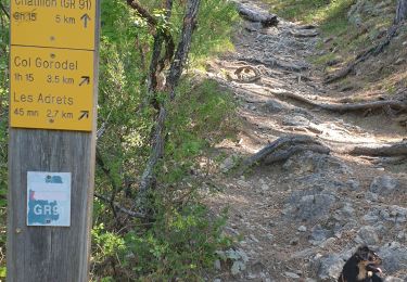
![](/images/other/stat-length.png)
![Tour Mountainbike Châtillon-en-Diois - Raid VTT Les Chemins du Soleil 2008 - Rando jour 2 et Elite jour 1 - Photo](https://media.geolcdn.com/t/1900/400/ext.pjpeg?maxdim=2&url=https%3A%2F%2Fservices.sitytrail.com%2FGeolivesWS%2FDownloadMedia.ashx%3FTrailID%3D102112%26Media%3D2501_1.jpg)
Raid VTT Les Chemins du Soleil 2008 - Rando jour 2 et Elite jour 1
tracegps
Benutzer
![Länge](/images/other/stat-length.png)
![Maximale Höhe](https://static1.geolcdn.com/siteimages/upload/files/1508320355ic_sort_altitude_max_24dp.png)
![Positive Höhendifferenz](https://static1.geolcdn.com/siteimages/upload/files/1508320355ic_sort_den_pos_24dp.png)
![Km-Effort](/images/other/stat-length.png)
![Min. Höhe](https://static1.geolcdn.com/siteimages/upload/files/1508320355ic_sort_altitude_min_24dp.png)
![Negative Höhendifferenz](https://static1.geolcdn.com/siteimages/upload/files/1508320355ic_sort_den_neg_24dp.png)
![Boucle](https://static1.geolcdn.com/siteimages/upload/files/16400158638029165_repeat_loop_refresh_sync_direction_icon.png)
![Mountainbike](https://static1.geolcdn.com/sitytour/trail-icons/202.png)
5h00
Schwierigkeit : Sehr schwierig
![Scannen Sie diesen QR-Code, um die Tour in der SityTrail-Anwendung zu öffnen](https://capi.geolives.com/qq0zvz2zws4bq2lad0pu/sitytour/trails/102112/qr.png?size=200)
Kostenlosegpshiking-Anwendung
Über SityTrail
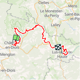
Tour Mountainbike von 58 km verfügbar auf Auvergne-Rhone-Alpen, Drôme, Châtillon-en-Diois. Diese Tour wird von tracegps vorgeschlagen.
Beschreibung
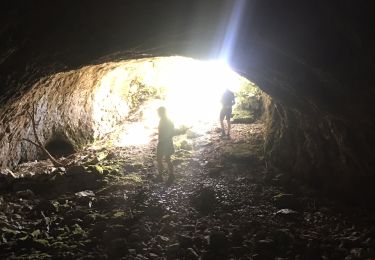
Ce Raid VTT est destiné à promouvoir l'itinéraire permanent qui relie la vallée du Rhône aux Alpes du sud (Ouest-Est) et le Vercors à la Provence (Nord-Sud) dont vous trouverez de plus amples informations sur Les chemins du soleil. Cette épreuve est organisée par l'association Raid VTT avec un partenariat étroit du Conseil Général de la Drôme et de la ville de Gap. Ce raid est considéré comme extrême du fait de la dénivelée très importante. La formule randonnée permet de découvrir en 3 jours un itinéraire habituellement programmé sur 5 à 7 jours et en élite, les concurrents viennent se mesurer sur une épreuve originale mais très engagée. Seules cinq à six équipes peuvent prétendre à la victoire mais pour tous les autres coureurs, c'est un défi extraordinaire que de finir. Ce parcours est la deuxième étape du groupe Rando et la première étape du groupe Elite.
Ort
Kommentare
Touren in der Umgebung
![Tour Wandern Châtillon-en-Diois - chatillon en Diois, GR91 - Photo](https://media.geolcdn.com/t/375/260/ext.jpg?maxdim=2&url=https%3A%2F%2Fstatic1.geolcdn.com%2Fsiteimages%2Fupload%2Ffiles%2F1553511878bg_sport_marche.png)
![Wandern Wandern](https://static1.geolcdn.com/sitytour/trail-icons/101.png)
Wandern
![](/images/other/stat-length.png)
![](https://static1.geolcdn.com/siteimages/upload/files/16400158638029165_repeat_loop_refresh_sync_direction_icon.png)
![Tour Wandern Châtillon-en-Diois - Pas des CLots - Photo](https://media.geolcdn.com/t/375/260/ext.jpg?maxdim=2&url=https%3A%2F%2Fstatic1.geolcdn.com%2Fsiteimages%2Fupload%2Ffiles%2F1553511878bg_sport_marche.png)
![Wandern Wandern](https://static1.geolcdn.com/sitytour/trail-icons/101.png)
Wandern
![](/images/other/stat-length.png)
![](https://static1.geolcdn.com/siteimages/upload/files/16400158638029165_repeat_loop_refresh_sync_direction_icon.png)
![Tour Wandern Châtillon-en-Diois - glandasse par chatillon - Photo](https://media.geolcdn.com/t/375/260/ext.jpg?maxdim=2&url=https%3A%2F%2Fstatic1.geolcdn.com%2Fsiteimages%2Fupload%2Ffiles%2F1553511878bg_sport_marche.png)
![Wandern Wandern](https://static1.geolcdn.com/sitytour/trail-icons/101.png)
Wandern
![](/images/other/stat-length.png)
![](https://static1.geolcdn.com/siteimages/upload/files/16400158638029165_repeat_loop_refresh_sync_direction_icon.png)
![Tour Wandern Châtillon-en-Diois - 26 grotte pellebit en traversee zel - Photo](https://media.geolcdn.com/t/375/260/d6c0b607-c5a4-4107-b67d-2ad35a261578.jpg&format=jpg&maxdim=2)
![Wandern Wandern](https://static1.geolcdn.com/sitytour/trail-icons/101.png)
Wandern
![](/images/other/stat-length.png)
![](https://static1.geolcdn.com/siteimages/upload/files/16400158638029165_repeat_loop_refresh_sync_direction_icon.png)
![Tour sport Châtillon-en-Diois - Châtillon en Diois col de Caux - Photo](https://media.geolcdn.com/t/375/260/c2c24153-915d-4a7e-8317-09a44e8b139f.jpg&format=jpg&maxdim=2)
sport
![](/images/other/stat-length.png)
![](https://static1.geolcdn.com/siteimages/upload/files/16400158638029165_repeat_loop_refresh_sync_direction_icon.png)
![Wandern Wandern](https://static1.geolcdn.com/sitytour/trail-icons/101.png)
Wandern
![](/images/other/stat-length.png)
![](https://static1.geolcdn.com/siteimages/upload/files/16400158638029165_repeat_loop_refresh_sync_direction_icon.png)
![Tour Wandern Châtillon-en-Diois - Cabane de Chatillon - Photo](https://media.geolcdn.com/t/375/260/ea94f18f-fca1-490f-aab1-2356b5263731.jpg&format=jpg&maxdim=2)
![Wandern Wandern](https://static1.geolcdn.com/sitytour/trail-icons/101.png)
Wandern
![](/images/other/stat-length.png)
![](https://static1.geolcdn.com/siteimages/upload/files/16400158638029165_repeat_loop_refresh_sync_direction_icon.png)
![Tour Wandern Châtillon-en-Diois - chatillon en Diois. les oursieres - Photo](https://media.geolcdn.com/t/375/260/ace35cbf-82be-45d6-acf9-562fc9f92be7.jpg&format=jpg&maxdim=2)
![Wandern Wandern](https://static1.geolcdn.com/sitytour/trail-icons/101.png)
Wandern
![](/images/other/stat-length.png)
![](https://static1.geolcdn.com/siteimages/upload/files/16400158638029165_repeat_loop_refresh_sync_direction_icon.png)
![Tour Wandern Châtillon-en-Diois - Chatillon en Diois la cabane - Photo](https://media.geolcdn.com/t/375/260/b72ec95b-4be8-438a-b0bc-6acf148e2da5.jpg&format=jpg&maxdim=2)
![Wandern Wandern](https://static1.geolcdn.com/sitytour/trail-icons/101.png)
Wandern
![](/images/other/stat-length.png)
![](https://static1.geolcdn.com/siteimages/upload/files/16400158638029165_repeat_loop_refresh_sync_direction_icon.png)