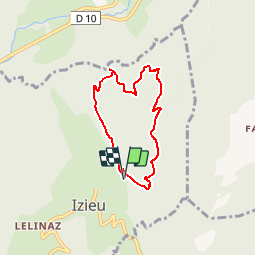
![](/images/other/stat-length.png)
![Tour Wandern Izieu - Le Grand Thur, Izieu - Photo](https://media.geolcdn.com/t/1900/400/ext.pjpeg?maxdim=2&url=https%3A%2F%2Fservices.sitytrail.com%2FGeolivesWS%2FDownloadMedia.ashx%3FTrailID%3D102110%26Media%3D2499_1.jpg)
Le Grand Thur, Izieu
tracegps
Benutzer
![Länge](/images/other/stat-length.png)
![Maximale Höhe](https://static1.geolcdn.com/siteimages/upload/files/1508320355ic_sort_altitude_max_24dp.png)
![Positive Höhendifferenz](https://static1.geolcdn.com/siteimages/upload/files/1508320355ic_sort_den_pos_24dp.png)
![Km-Effort](/images/other/stat-length.png)
![Min. Höhe](https://static1.geolcdn.com/siteimages/upload/files/1508320355ic_sort_altitude_min_24dp.png)
![Negative Höhendifferenz](https://static1.geolcdn.com/siteimages/upload/files/1508320355ic_sort_den_neg_24dp.png)
![Boucle](https://static1.geolcdn.com/siteimages/upload/files/16400158638029165_repeat_loop_refresh_sync_direction_icon.png)
![Wandern](https://static1.geolcdn.com/sitytour/trail-icons/101.png)
2h30
Schwierigkeit : Einfach
![Scannen Sie diesen QR-Code, um die Tour in der SityTrail-Anwendung zu öffnen](https://capi.geolives.com/qq0zvz2zws4bq2lad0pu/sitytour/trails/102110/qr.png?size=200)
Kostenlosegpshiking-Anwendung
Über SityTrail
Tour Wandern von 5,8 km verfügbar auf Auvergne-Rhone-Alpen, Ain, Izieu. Diese Tour wird von tracegps vorgeschlagen.
Beschreibung
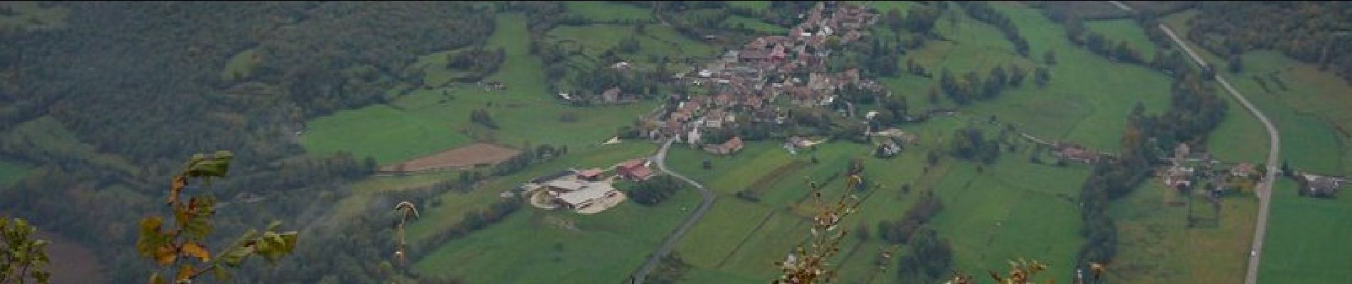
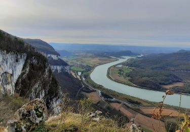
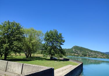
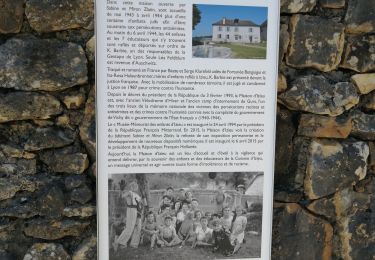
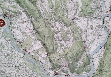
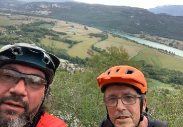
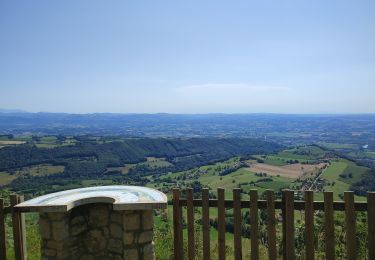
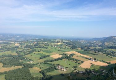
Comment randonner autour du village d'Izieu sans monter au Grand-Thur. En partant de la route forestière, l'ascension est inévitable. Taire la beauté de l'ensemble compact de maisons typiques du Bugey seulement taché de quelques constructions récentes aux crépis de couleurs trop vives pour passer inaperçues serait aussi impardonnable. La montée est conseillée par le versant Ouest – le plus escarpé. Pour le retour, de nombreuses possibilités s'offrent aux randonneurs par le versant qui domine Fay, plusieurs itinéraires ont déjà été décrits. Lire par exemple : De Fay au Grand Thur par la montagne d'Izieu qui du sommet rattrape la petite route forestière. Description complète sur sentier-nature.com : Le Grand Thur, Izieu
Ort
Kommentare
Touren in der Umgebung
![Tour Motor Arboys-en-Bugey - Rando remise en forme - Photo](https://media.geolcdn.com/t/375/260/ext.jpg?maxdim=2&url=https%3A%2F%2Fstatic1.geolcdn.com%2Fsiteimages%2Fupload%2Ffiles%2F15247431544x4.jpg)
![Motor Motor](https://static1.geolcdn.com/sitytour/trail-icons/400.png)
Motor
![](/images/other/stat-length.png)
![](https://static1.geolcdn.com/siteimages/upload/files/16400158638029165_repeat_loop_refresh_sync_direction_icon.png)
![Tour Reiten Peyrieu - peyrieu Izieu valide cavaliersp - Photo](https://media.geolcdn.com/t/375/260/2c32351f-e06a-4a02-927a-937d3ed0c61b.jpg&format=jpg&maxdim=2)
![Reiten Reiten](https://static1.geolcdn.com/sitytour/trail-icons/301.png)
Reiten
![](/images/other/stat-length.png)
![](https://static1.geolcdn.com/siteimages/upload/files/16400158638029165_repeat_loop_refresh_sync_direction_icon.png)
![Tour Wandern Saint-Genix-les-Villages - Mont Tournier - Photo](https://media.geolcdn.com/t/375/260/ca4047a9-59c8-4dcf-93d3-127eea8f1a84.jpg&format=jpg&maxdim=2)
![Wandern Wandern](https://static1.geolcdn.com/sitytour/trail-icons/101.png)
Wandern
![](/images/other/stat-length.png)
![](https://static1.geolcdn.com/siteimages/upload/files/16400158638029165_repeat_loop_refresh_sync_direction_icon.png)
![Tour Reiten Champagneux - 202206 boucle Gourjux - Photo](https://media.geolcdn.com/t/375/260/c8713771-86f9-46ed-8bc5-7397cec70731.jpg&format=jpg&maxdim=2)
![Reiten Reiten](https://static1.geolcdn.com/sitytour/trail-icons/301.png)
Reiten
![](/images/other/stat-length.png)
![](https://static1.geolcdn.com/siteimages/upload/files/16400158638029165_repeat_loop_refresh_sync_direction_icon.png)
![Tour Wandern Brégnier-Cordon - Cascade de glandieu, grand Thur en boucle dans l'Ain - Photo](https://media.geolcdn.com/t/375/260/1036fcd4-7da6-4120-94e4-e224fe2ab54b.jpg&format=jpg&maxdim=2)
![Wandern Wandern](https://static1.geolcdn.com/sitytour/trail-icons/101.png)
Wandern
![](/images/other/stat-length.png)
![](https://static1.geolcdn.com/siteimages/upload/files/16400158638029165_repeat_loop_refresh_sync_direction_icon.png)
![Tour Hybrid-Bike Brégnier-Cordon - 01-vtt-viarhona-Bregnier-Cordon-2-boucles 30km et 20km - Photo](https://media.geolcdn.com/t/375/260/e2a45222-1cf4-421d-9652-5fba85609478.jpg&format=jpg&maxdim=2)
![Hybrid-Bike Hybrid-Bike](https://static1.geolcdn.com/sitytour/trail-icons/203.png)
Hybrid-Bike
![](/images/other/stat-length.png)
![](https://static1.geolcdn.com/siteimages/upload/files/16400158638029165_repeat_loop_refresh_sync_direction_icon.png)
![Tour Mountainbike Peyrieu - Sur Fays - Photo](https://media.geolcdn.com/t/375/260/bba9d891-7509-4cec-84db-7eb740a87a92.jpg&format=jpg&maxdim=2)
![Mountainbike Mountainbike](https://static1.geolcdn.com/sitytour/trail-icons/202.png)
Mountainbike
![](/images/other/stat-length.png)
![](https://static1.geolcdn.com/siteimages/upload/files/16400158638029165_repeat_loop_refresh_sync_direction_icon.png)
![Tour Reiten Saint-Genix-les-Villages - 201106 boucle StMauriceRotherens - Photo](https://media.geolcdn.com/t/375/260/c9374c5a-470a-410c-8894-565c5f062cd7.jpg&format=jpg&maxdim=2)
![Reiten Reiten](https://static1.geolcdn.com/sitytour/trail-icons/301.png)
Reiten
![](/images/other/stat-length.png)
![](https://static1.geolcdn.com/siteimages/upload/files/16400158638029165_repeat_loop_refresh_sync_direction_icon.png)
![Tour Wandern Saint-Genix-les-Villages - GR 9 Étape 16 St Maurice de Rotherens - Attignat Oncin - Photo](https://media.geolcdn.com/t/375/260/204c72a9-259d-4e14-a763-e168cda63aa8.jpg&format=jpg&maxdim=2)
![Wandern Wandern](https://static1.geolcdn.com/sitytour/trail-icons/101.png)
Wandern
![](/images/other/stat-length.png)
![](https://static1.geolcdn.com/siteimages/upload/files/16400158638029165_repeat_loop_refresh_sync_direction_icon.png)