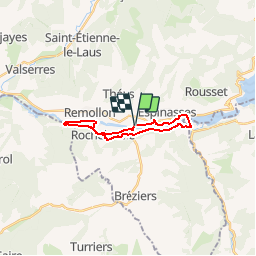
![](/images/other/stat-length.png)
![Tour Mountainbike Théus - Espace VTT FFC de Serre-Ponçon - Durance - Circuit n°15 - Le Plan - Photo](https://media.geolcdn.com/t/1900/400/ext.pjpeg?maxdim=2&url=https%3A%2F%2Fservices.sitytrail.com%2FGeolivesWS%2FDownloadMedia.ashx%3FTrailID%3D102058%26Media%3D2380_1.jpg)
Espace VTT FFC de Serre-Ponçon - Durance - Circuit n°15 - Le Plan
tracegps
Benutzer
![Länge](/images/other/stat-length.png)
![Maximale Höhe](https://static1.geolcdn.com/siteimages/upload/files/1508320355ic_sort_altitude_max_24dp.png)
![Positive Höhendifferenz](https://static1.geolcdn.com/siteimages/upload/files/1508320355ic_sort_den_pos_24dp.png)
![Km-Effort](/images/other/stat-length.png)
![Min. Höhe](https://static1.geolcdn.com/siteimages/upload/files/1508320355ic_sort_altitude_min_24dp.png)
![Negative Höhendifferenz](https://static1.geolcdn.com/siteimages/upload/files/1508320355ic_sort_den_neg_24dp.png)
![Boucle](https://static1.geolcdn.com/siteimages/upload/files/16400158638029165_repeat_loop_refresh_sync_direction_icon.png)
![Mountainbike](https://static1.geolcdn.com/sitytour/trail-icons/202.png)
1h19
Schwierigkeit : Medium
![Scannen Sie diesen QR-Code, um die Tour in der SityTrail-Anwendung zu öffnen](https://capi.geolives.com/qq0zvz2zws4bq2lad0pu/sitytour/trails/102058/qr.png?size=200)
Kostenlosegpshiking-Anwendung
Über SityTrail
Tour Mountainbike von 17,1 km verfügbar auf Provence-Alpes-Côte d'Azur, Hochalpen, Théus. Diese Tour wird von tracegps vorgeschlagen.
Beschreibung
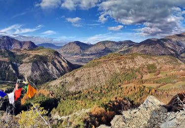
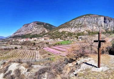
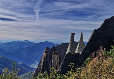
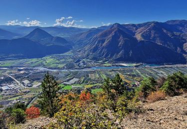
Espace VTT FFC de Serre-Ponçon - Durance Circuit labellisé par la Fédération Française de Cyclisme. Deux départs possibles depuis l’Office du Tourisme du Pays de Serre-Ponçon et le camping des Trois Lacs. Circuit familial en boucle d’une certaine longueur, mais presque à plat. Découverte des Trois Lacs de Rochebrune entre les vergers et la Durance. Rochebrune et ses belles vues sur Théus, la montagne Saint Maurice et le mont Colombis. Le hameau de Gréoliers et le canal de la Durance. Espinasses, joli village étalé au pied des Montagnes.
Ort
Kommentare
Touren in der Umgebung
![Tour Wandern Théus - R47 Les Demoiselles Coiffees - Photo](https://media.geolcdn.com/t/375/260/ext.jpg?maxdim=2&url=https%3A%2F%2Fservices.sitytrail.com%2FGeolivesWS%2FDownloadMedia.ashx%3FTrailID%3D890906%26Media%3Dc8a3e36a-3aa2-4d75-b341-12feab72a468.jpg)
![Wandern Wandern](https://static1.geolcdn.com/sitytour/trail-icons/101.png)
Wandern
![](/images/other/stat-length.png)
![](https://static1.geolcdn.com/siteimages/upload/files/16400158638029165_repeat_loop_refresh_sync_direction_icon.png)
![Tour Wandern Théus - Les demoiselles coiffées - Photo](https://media.geolcdn.com/t/375/260/1a3b1ded-039c-4f3a-9433-82de273504ad.jpeg&format=jpg&maxdim=2)
![Wandern Wandern](https://static1.geolcdn.com/sitytour/trail-icons/101.png)
Wandern
![](/images/other/stat-length.png)
![](https://static1.geolcdn.com/siteimages/upload/files/16400158638029165_repeat_loop_refresh_sync_direction_icon.png)
![Tour Wandern Rochebrune - Chapelle Saint-Sixte Via Rochebrune - Photo](https://media.geolcdn.com/t/375/260/0f20d05e-b7e6-44b4-b471-8732af4f1fc9.jpg&format=jpg&maxdim=2)
![Wandern Wandern](https://static1.geolcdn.com/sitytour/trail-icons/101.png)
Wandern
![](/images/other/stat-length.png)
![](https://static1.geolcdn.com/siteimages/upload/files/16400158638029165_repeat_loop_refresh_sync_direction_icon.png)
![Tour Wandern Gigors - GIGORS Cretes des Barses par variante n - Photo](https://media.geolcdn.com/t/375/260/dbf914d6-b25f-4023-818e-fa0613cb7f91.jpg&format=jpg&maxdim=2)
![Wandern Wandern](https://static1.geolcdn.com/sitytour/trail-icons/101.png)
Wandern
![](/images/other/stat-length.png)
![](https://static1.geolcdn.com/siteimages/upload/files/16400158638029165_repeat_loop_refresh_sync_direction_icon.png)
![Tour Wandern Remollon - Remollon-un-tresor-cache-de-la-vallee-de-la-durance - Photo](https://media.geolcdn.com/t/375/260/073a624b-9a54-4ca5-a179-7003c0d6383d.jpg&format=jpg&maxdim=2)
![Wandern Wandern](https://static1.geolcdn.com/sitytour/trail-icons/101.png)
Wandern
![](/images/other/stat-length.png)
![](https://static1.geolcdn.com/siteimages/upload/files/16400158638029165_repeat_loop_refresh_sync_direction_icon.png)
![Tour Wandern Espinasses - Salle-de-bal-des-demoiselles-coiffees-via-serre-giraud - Photo](https://media.geolcdn.com/t/375/260/308e4b93-b724-42e4-abd4-cc3772156253.jpg&format=jpg&maxdim=2)
![Wandern Wandern](https://static1.geolcdn.com/sitytour/trail-icons/101.png)
Wandern
![](/images/other/stat-length.png)
![](https://static1.geolcdn.com/siteimages/upload/files/16400158638029165_repeat_loop_refresh_sync_direction_icon.png)
![Tour Wandern Espinasses - les-demoiselles-coiffees-d-espinasses-theus-et-remollon - Photo](https://media.geolcdn.com/t/375/260/1af52faf-437c-42bd-b3af-b635ea9a33d1.jpg&format=jpg&maxdim=2)
![Wandern Wandern](https://static1.geolcdn.com/sitytour/trail-icons/101.png)
Wandern
![](/images/other/stat-length.png)
![](https://static1.geolcdn.com/siteimages/upload/files/16400158638029165_repeat_loop_refresh_sync_direction_icon.png)
![Tour Wandern Remollon - Des Demoiselles Coiffées aux balcons de Remollon - Photo](https://media.geolcdn.com/t/375/260/2094a0e8-535c-4f81-bf59-f1f898a15092.jpg&format=jpg&maxdim=2)
![Wandern Wandern](https://static1.geolcdn.com/sitytour/trail-icons/101.png)
Wandern
![](/images/other/stat-length.png)
![](https://static1.geolcdn.com/siteimages/upload/files/16400158638029165_repeat_loop_refresh_sync_direction_icon.png)
![Tour Wandern Gigors - sabots de venus gigors 860m 12kms - Photo](https://media.geolcdn.com/t/375/260/4376e0fb-d973-434a-abc5-b70530b4e185.jpg&format=jpg&maxdim=2)
![Wandern Wandern](https://static1.geolcdn.com/sitytour/trail-icons/101.png)
Wandern
![](/images/other/stat-length.png)
![](https://static1.geolcdn.com/siteimages/upload/files/16400158638029165_repeat_loop_refresh_sync_direction_icon.png)