![](/images/other/stat-length.png)
![Tour Mountainbike Saint-Anthème - Espace VTT FFC de la Vallée de l'Ance - Circuit n° 6 - Photo](https://media.geolcdn.com/t/1900/400/ext.pjpeg?maxdim=2&url=https%3A%2F%2Fservices.sitytrail.com%2FGeolivesWS%2FDownloadMedia.ashx%3FTrailID%3D101966%26Media%3D2261_1.jpg)
Espace VTT FFC de la Vallée de l'Ance - Circuit n° 6
tracegps
Benutzer
![Länge](/images/other/stat-length.png)
![Maximale Höhe](https://static1.geolcdn.com/siteimages/upload/files/1508320355ic_sort_altitude_max_24dp.png)
![Positive Höhendifferenz](https://static1.geolcdn.com/siteimages/upload/files/1508320355ic_sort_den_pos_24dp.png)
![Km-Effort](/images/other/stat-length.png)
![Min. Höhe](https://static1.geolcdn.com/siteimages/upload/files/1508320355ic_sort_altitude_min_24dp.png)
![Negative Höhendifferenz](https://static1.geolcdn.com/siteimages/upload/files/1508320355ic_sort_den_neg_24dp.png)
![Boucle](https://static1.geolcdn.com/siteimages/upload/files/16400158638029165_repeat_loop_refresh_sync_direction_icon.png)
![Mountainbike](https://static1.geolcdn.com/sitytour/trail-icons/202.png)
3h00
Schwierigkeit : Sehr schwierig
![Scannen Sie diesen QR-Code, um die Tour in der SityTrail-Anwendung zu öffnen](https://capi.geolives.com/qq0zvz2zws4bq2lad0pu/sitytour/trails/101966/qr.png?size=200)
Kostenlosegpshiking-Anwendung
Über SityTrail
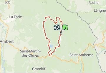
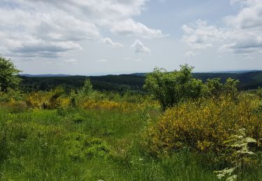
Tour Mountainbike von 23 km verfügbar auf Auvergne-Rhone-Alpen, Puy-de-Dôme, Saint-Anthème. Diese Tour wird von tracegps vorgeschlagen.
Beschreibung
Espace VTT FFC de la Vallée de l’Ance Circuit labellisé par la Fédération Française de Cyclisme. Ce circuit plutôt physique et technique vous permettra d’accéder à la beauté sauvage des grands espaces des Hautes-Chaumes. Vous serez récompensé par la découverte d’un magnifique panorama : barrage des Pradeaux, monts du Livradois, monts Dôme, monts Dore, monts du Cantal, monts du Velay.
Ort
Kommentare
Touren in der Umgebung
![Tour Wandern Valcivières - Les Jasseries des Supeyres - Valcivières - Photo](https://media.geolcdn.com/t/375/260/ext.jpg?maxdim=2&url=https%3A%2F%2Fservices.sitytrail.com%2FGeolivesWS%2FDownloadMedia.ashx%3FTrailID%3D173065%26Media%3D14595_6.jpg)
![Wandern Wandern](https://static1.geolcdn.com/sitytour/trail-icons/101.png)
Wandern
![](/images/other/stat-length.png)
![](https://static1.geolcdn.com/siteimages/upload/files/16400158638029165_repeat_loop_refresh_sync_direction_icon.png)
![Tour Wandern Valcivières - Le colporteur des jasseries - Col des Supeyres -Valcivières - Photo](https://media.geolcdn.com/t/375/260/ext.jpg?maxdim=2&url=https%3A%2F%2Fservices.sitytrail.com%2FGeolivesWS%2FDownloadMedia.ashx%3FTrailID%3D107152%26Media%3D11995_3.jpg)
![Wandern Wandern](https://static1.geolcdn.com/sitytour/trail-icons/101.png)
Wandern
![](/images/other/stat-length.png)
![](https://static1.geolcdn.com/siteimages/upload/files/16400158638029165_repeat_loop_refresh_sync_direction_icon.png)
![Tour Zu Fuß Saint-Anthème - Le Colporteur des Jasseries - Photo](https://media.geolcdn.com/t/375/260/bb8cf573-2abe-46cd-9375-5ca50a964f5d.jpeg&format=jpg&maxdim=2)
![Zu Fuß Zu Fuß](https://static1.geolcdn.com/sitytour/trail-icons/100.png)
Zu Fuß
![](/images/other/stat-length.png)
![](https://static1.geolcdn.com/siteimages/upload/files/16400158638029165_repeat_loop_refresh_sync_direction_icon.png)
![Tour Zu Fuß Valcivières - Les Hautes Chaumes - Photo](https://media.geolcdn.com/t/375/260/c021c51c-10d6-4fa3-97fc-c48a9b2a32e9.jpeg&format=jpg&maxdim=2)
![Zu Fuß Zu Fuß](https://static1.geolcdn.com/sitytour/trail-icons/100.png)
Zu Fuß
![](/images/other/stat-length.png)
![](https://static1.geolcdn.com/siteimages/upload/files/16400158638029165_repeat_loop_refresh_sync_direction_icon.png)
![Tour Zu Fuß Saint-Anthème - Beauvoir - Photo](https://media.geolcdn.com/t/375/260/ae7f9019-dbcd-4e47-bc79-4b22438f3ce2.jpeg&format=jpg&maxdim=2)
![Zu Fuß Zu Fuß](https://static1.geolcdn.com/sitytour/trail-icons/100.png)
Zu Fuß
![](/images/other/stat-length.png)
![](https://static1.geolcdn.com/siteimages/upload/files/16400158638029165_repeat_loop_refresh_sync_direction_icon.png)
![Tour Wandern Saint-Anthème - Col des Supeyres au départ du Coq noir - Photo](https://media.geolcdn.com/t/375/260/a5f589cb-cae4-4a52-a71d-8c519e83f668.jpg&format=jpg&maxdim=2)
![Wandern Wandern](https://static1.geolcdn.com/sitytour/trail-icons/101.png)
Wandern
![](/images/other/stat-length.png)
![](https://static1.geolcdn.com/siteimages/upload/files/16400158638029165_repeat_loop_refresh_sync_direction_icon.png)
![Tour Zu Fuß Saint-Anthème - Les Prats-de-la-Chaux - Photo](https://media.geolcdn.com/t/375/260/ae7f9019-dbcd-4e47-bc79-4b22438f3ce2.jpeg&format=jpg&maxdim=2)
![Zu Fuß Zu Fuß](https://static1.geolcdn.com/sitytour/trail-icons/100.png)
Zu Fuß
![](/images/other/stat-length.png)
![](https://static1.geolcdn.com/siteimages/upload/files/16400158638029165_repeat_loop_refresh_sync_direction_icon.png)
![Tour Mountainbike Saint-Anthème - Descente barracuchet Montbrison - Photo](https://media.geolcdn.com/t/375/260/2544011a-6e3c-42be-8ca9-7444665c9346.jpg&format=jpg&maxdim=2)
![Mountainbike Mountainbike](https://static1.geolcdn.com/sitytour/trail-icons/202.png)
Mountainbike
![](/images/other/stat-length.png)
![](https://static1.geolcdn.com/siteimages/upload/files/16400158638029165_repeat_loop_refresh_sync_direction_icon.png)
![Tour Wandern Saint-Anthème - boucle des Pradeaux - Photo](https://media.geolcdn.com/t/375/260/ext.jpg?maxdim=2&url=https%3A%2F%2Fservices.sitytrail.com%2FGeolivesWS%2FDownloadMedia.ashx%3FTrailID%3D983955%26Media%3Dfix__20180610133330.jpg)
![Wandern Wandern](https://static1.geolcdn.com/sitytour/trail-icons/101.png)
Wandern
![](/images/other/stat-length.png)
![](https://static1.geolcdn.com/siteimages/upload/files/16400158638029165_repeat_loop_refresh_sync_direction_icon.png)