![](/images/other/stat-length.png)
![Tour Wandern Cancale - Cancale - Plage du Verger - Île du Guesclin - Photo](https://media.geolcdn.com/t/1900/400/ext.pjpeg?maxdim=2&url=https%3A%2F%2Fstatic1.geolcdn.com%2Fsiteimages%2Fupload%2Ffiles%2F1553511878bg_sport_marche.png)
Cancale - Plage du Verger - Île du Guesclin
toporient
Benutzer
![Länge](/images/other/stat-length.png)
Länge
3,2 km
![Maximale Höhe](https://static1.geolcdn.com/siteimages/upload/files/1508320355ic_sort_altitude_max_24dp.png)
Maximale Höhe
36 m
![Positive Höhendifferenz](https://static1.geolcdn.com/siteimages/upload/files/1508320355ic_sort_den_pos_24dp.png)
Positive Höhendifferenz
46 m
![Km-Effort](/images/other/stat-length.png)
Km-Effort
3,8 km
![Min. Höhe](https://static1.geolcdn.com/siteimages/upload/files/1508320355ic_sort_altitude_min_24dp.png)
Min. Höhe
6 m
![Negative Höhendifferenz](https://static1.geolcdn.com/siteimages/upload/files/1508320355ic_sort_den_neg_24dp.png)
Negative Höhendifferenz
46 m
![Boucle](https://static1.geolcdn.com/siteimages/upload/files/16400158638029165_repeat_loop_refresh_sync_direction_icon.png)
Boucle
Ja
Erstellungsdatum :
2019-01-15 14:19:26.557
Letzte Änderung :
2019-01-15 14:19:26.557
![Wandern](https://static1.geolcdn.com/sitytour/trail-icons/101.png)
49m
Schwierigkeit : Medium
![Scannen Sie diesen QR-Code, um die Tour in der SityTrail-Anwendung zu öffnen](https://capi.geolives.com/qq0zvz2zws4bq2lad0pu/sitytour/trails/1018491/qr.png?size=200)
Kostenlosegpshiking-Anwendung
Über SityTrail
Tour Wandern von 3,2 km verfügbar auf Bretagne, Ille-et-Vilaine, Cancale. Diese Tour wird von toporient vorgeschlagen.
Beschreibung
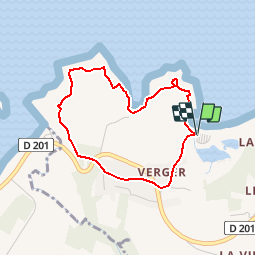
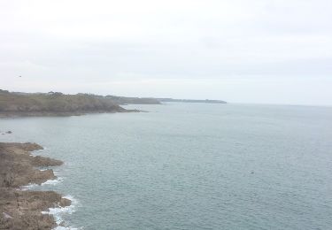
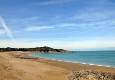
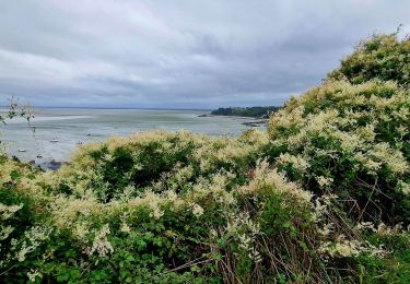
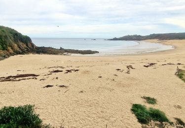
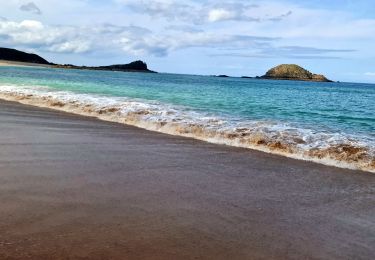
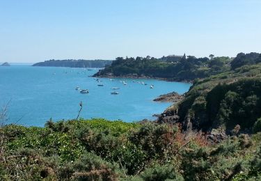
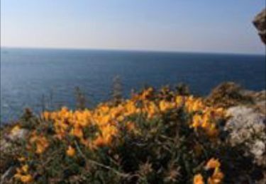
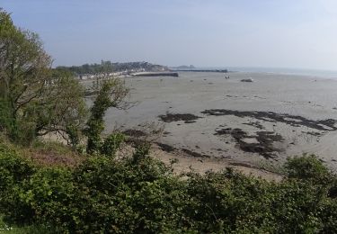
Parking et départ de la plage du Verger. Courte mais sportive randonnée, qui emprunte le sentier côtier jusqu'à voir l'île et fort du Guesclin. Retour par le joli hameau et la chapelle du Verger.
Ort
Land:
France
Region :
Bretagne
Abteilung/Provinz :
Ille-et-Vilaine
Kommune :
Cancale
Standort:
Unknown
Gehen Sie:(Dec)
Gehen Sie:(UTM)
582474 ; 5394182 (30U) N.
Kommentare
Touren in der Umgebung
![Tour Wandern Cancale - cancale-pointe du grouin - Photo](https://media.geolcdn.com/t/375/260/ext.jpg?maxdim=2&url=https%3A%2F%2Fservices.sitytrail.com%2FGeolivesWS%2FDownloadMedia.ashx%3FTrailID%3D562635%26Media%3D20160502130406.jpg)
![Wandern Wandern](https://static1.geolcdn.com/sitytour/trail-icons/101.png)
cancale-pointe du grouin
Wandern
Einfach
(1)
Cancale,
Bretagne,
Ille-et-Vilaine,
France
![](/images/other/stat-length.png)
7,4 km | 9,1 km-effort
2h 12min
![](https://static1.geolcdn.com/siteimages/upload/files/16400158638029165_repeat_loop_refresh_sync_direction_icon.png)
Ja
![Tour Wandern Cancale - Balade vers la Pointe du Grouin - Cancale - Photo](https://media.geolcdn.com/t/375/260/ext.jpg?maxdim=2&url=https%3A%2F%2Fservices.sitytrail.com%2FGeolivesWS%2FDownloadMedia.ashx%3FTrailID%3D317635%26Media%3D16903_4.jpg)
![Wandern Wandern](https://static1.geolcdn.com/sitytour/trail-icons/101.png)
Balade vers la Pointe du Grouin - Cancale
Wandern
Medium
(4)
Cancale,
Bretagne,
Ille-et-Vilaine,
France
![](/images/other/stat-length.png)
13,2 km | 15,9 km-effort
3h 30min
![](https://static1.geolcdn.com/siteimages/upload/files/16400158638029165_repeat_loop_refresh_sync_direction_icon.png)
Ja
![Wandern Wandern](https://static1.geolcdn.com/sitytour/trail-icons/101.png)
SityTrail - GR 34 Port Picain -- Saint Malo
Wandern
Sehr schwierig
Cancale,
Bretagne,
Ille-et-Vilaine,
France
![](/images/other/stat-length.png)
24 km | 28 km-effort
6h 24min
![](https://static1.geolcdn.com/siteimages/upload/files/16400158638029165_repeat_loop_refresh_sync_direction_icon.png)
Nein
![Tour Zu Fuß Cancale - Balade rapide à Cancale (hors groupe) - Photo](https://media.geolcdn.com/t/375/260/8cca7f8b-f64f-48e7-9459-b60c481745c3.jpg&format=jpg&maxdim=2)
![Zu Fuß Zu Fuß](https://static1.geolcdn.com/sitytour/trail-icons/100.png)
Balade rapide à Cancale (hors groupe)
Zu Fuß
Einfach
Cancale,
Bretagne,
Ille-et-Vilaine,
France
![](/images/other/stat-length.png)
6 km | 7,9 km-effort
1h 47min
![](https://static1.geolcdn.com/siteimages/upload/files/16400158638029165_repeat_loop_refresh_sync_direction_icon.png)
Ja
![Tour Wandern Cancale - Boucle Anse du Guesclin - Photo](https://media.geolcdn.com/t/375/260/1d52cbbc-9ca2-4f7c-8936-3e1e451657b1.jpg&format=jpg&maxdim=2)
![Wandern Wandern](https://static1.geolcdn.com/sitytour/trail-icons/101.png)
Boucle Anse du Guesclin
Wandern
Einfach
Cancale,
Bretagne,
Ille-et-Vilaine,
France
![](/images/other/stat-length.png)
6,1 km | 7,2 km-effort
2h 0min
![](https://static1.geolcdn.com/siteimages/upload/files/16400158638029165_repeat_loop_refresh_sync_direction_icon.png)
Ja
![Tour Wandern Saint-Coulomb - Boucle Pointe du Meinga J3 - Photo](https://media.geolcdn.com/t/375/260/76681f2a-df72-496e-aa02-0c3f7a289a24.jpg&format=jpg&maxdim=2)
![Wandern Wandern](https://static1.geolcdn.com/sitytour/trail-icons/101.png)
Boucle Pointe du Meinga J3
Wandern
Sehr leicht
Saint-Coulomb,
Bretagne,
Ille-et-Vilaine,
France
![](/images/other/stat-length.png)
5 km | 6,4 km-effort
1h 41min
![](https://static1.geolcdn.com/siteimages/upload/files/16400158638029165_repeat_loop_refresh_sync_direction_icon.png)
Ja
![Tour Wandern Cancale - Cancale Port Mer - 15.3km 290m 5h05 - 2017 06 19 - Photo](https://media.geolcdn.com/t/375/260/a3e4f02b-7f79-4247-9c5f-7345570d1680.jpg&format=jpg&maxdim=2)
![Wandern Wandern](https://static1.geolcdn.com/sitytour/trail-icons/101.png)
Cancale Port Mer - 15.3km 290m 5h05 - 2017 06 19
Wandern
Einfach
Cancale,
Bretagne,
Ille-et-Vilaine,
France
![](/images/other/stat-length.png)
15,3 km | 18,5 km-effort
5h 0min
![](https://static1.geolcdn.com/siteimages/upload/files/16400158638029165_repeat_loop_refresh_sync_direction_icon.png)
Ja
![Tour Wandern Saint-Coulomb - La pointe du meinga ( saint coulomb ) - Photo](https://media.geolcdn.com/t/375/260/ext.jpg?maxdim=2&url=https%3A%2F%2Fservices.sitytrail.com%2FGeolivesWS%2FDownloadMedia.ashx%3FTrailID%3D762584%26Media%3De1ddeda8-5a48-4968-8b23-d0b18aea6452.jpg)
![Wandern Wandern](https://static1.geolcdn.com/sitytour/trail-icons/101.png)
La pointe du meinga ( saint coulomb )
Wandern
Medium
Saint-Coulomb,
Bretagne,
Ille-et-Vilaine,
France
![](/images/other/stat-length.png)
8 km | 9,9 km-effort
2h 15min
![](https://static1.geolcdn.com/siteimages/upload/files/16400158638029165_repeat_loop_refresh_sync_direction_icon.png)
Nein
![Tour Mountainbike Saint-Coulomb - VTT à Saint coulombe - Photo](https://media.geolcdn.com/t/375/260/ext.jpg?maxdim=2&url=https%3A%2F%2Fservices.sitytrail.com%2FGeolivesWS%2FDownloadMedia.ashx%3FTrailID%3D751359%26Media%3Dad463f90-267f-4f47-837b-b813ce0f6807.JPG)
![Mountainbike Mountainbike](https://static1.geolcdn.com/sitytour/trail-icons/202.png)
VTT à Saint coulombe
Mountainbike
Medium
Saint-Coulomb,
Bretagne,
Ille-et-Vilaine,
France
![](/images/other/stat-length.png)
31 km | 35 km-effort
2h 20min
![](https://static1.geolcdn.com/siteimages/upload/files/16400158638029165_repeat_loop_refresh_sync_direction_icon.png)
Nein