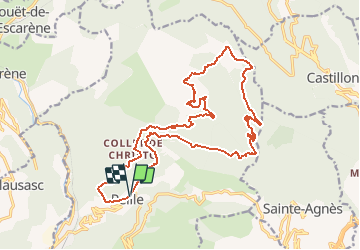
![](/images/other/stat-length.png)
![Tour Mountainbike Peille - Espace VTT FFC Sospel - N° 15 : Le Castel d'Ongrand - Photo](https://media.geolcdn.com/t/1900/400/ext.pjpeg?maxdim=2&url=https%3A%2F%2Fservices.sitytrail.com%2FGeolivesWS%2FDownloadMedia.ashx%3FTrailID%3D101785%26Media%3D2058_1.jpg)
Espace VTT FFC Sospel - N° 15 : Le Castel d'Ongrand
tracegps
Benutzer
![Länge](/images/other/stat-length.png)
![Maximale Höhe](https://static1.geolcdn.com/siteimages/upload/files/1508320355ic_sort_altitude_max_24dp.png)
![Positive Höhendifferenz](https://static1.geolcdn.com/siteimages/upload/files/1508320355ic_sort_den_pos_24dp.png)
![Km-Effort](/images/other/stat-length.png)
![Min. Höhe](https://static1.geolcdn.com/siteimages/upload/files/1508320355ic_sort_altitude_min_24dp.png)
![Negative Höhendifferenz](https://static1.geolcdn.com/siteimages/upload/files/1508320355ic_sort_den_neg_24dp.png)
![Boucle](https://static1.geolcdn.com/siteimages/upload/files/16400158638029165_repeat_loop_refresh_sync_direction_icon.png)
![Mountainbike](https://static1.geolcdn.com/sitytour/trail-icons/202.png)
2h00
Schwierigkeit : Schwierig
![Scannen Sie diesen QR-Code, um die Tour in der SityTrail-Anwendung zu öffnen](https://capi.geolives.com/qq0zvz2zws4bq2lad0pu/sitytour/trails/101785/qr.png?size=200)
Kostenlosegpshiking-Anwendung
Über SityTrail
Tour Mountainbike von 23 km verfügbar auf Provence-Alpes-Côte d'Azur, Seealpen, Peille. Diese Tour wird von tracegps vorgeschlagen.
Beschreibung
Espace VTT FFC de Sospel Circuit labellisé par la Fédération Française de Cyclisme. Au Castel d'Ongland, quitter momentanéement le sentier et grimper sur l'éperon rocheux. Le Mont Ongrand 869 m. Sur le versant sud, les reste de la Chapelle Saint Jean d'Ongrand. Un peu plus au nord,sur un rocher incliné, une excavation creusée dans celui-ci "le pétrin dit des païens" reste une énigme pour les historiens. De la place de la République, monter jusqu'à l'avenue A.BRIAND, prendre à gauche de la maison de retraite la voirie communale de Saint Bernard,. Après le réservoir d'eau,emprunter la piste jusqu'à la barrière verte. Poursuivre la piste ONF de la Cervetta. A environ 1 Km, la piste tourne au nord au pied de jACQUES (gros rocher surplombant le vide). La piste monte régulièrement puis redescend. Arrivé au lieu dit "Les Sporsins", laisser à gauche l'itinéraire 11, et poursuivre jusqu'au Col des Banquettes. Prendre à gauche la route stratégique. A l'intersection avec les parcours 17 et 19, piste du mont Ours, la piste redescent au col de Ségra. Poursuivre la route goudronnée, après la bifurcation avec une piste à droite (10 m), prendre le chemin à gauche qui descent perpendiculairement. A la patte d'oie, prendre le sentier à droite. après une descente, on atteint un replat sous le rocher du Castel d'Ongrand. Prendre à gauche dans le pré, passer sous les ruines d'une vieille batisse et redescendre côté sud vers le quartier d'Ongrand. On atteint une route goudronnée, bifurquer à gauche, remonter jusqu'au chemin vicinal n°7 par le quartier Gazouil. Rejoindre le village.
Ort
Kommentare
Touren in der Umgebung
![Tour Wandern Peillon - Via Alpina - R161: Peillon > Monaco - Place du Palais - Photo](https://media.geolcdn.com/t/375/260/ext.jpg?maxdim=2&url=https%3A%2F%2Fservices.sitytrail.com%2FGeolivesWS%2FDownloadMedia.ashx%3FTrailID%3D109722%26Media%3D4434_1.jpg)
![Wandern Wandern](https://static1.geolcdn.com/sitytour/trail-icons/101.png)
Wandern
![](/images/other/stat-length.png)
![](https://static1.geolcdn.com/siteimages/upload/files/16400158638029165_repeat_loop_refresh_sync_direction_icon.png)
![Tour Zu Fuß Peille - Cime de Baudon - Photo](https://media.geolcdn.com/t/375/260/9fe230af-c31e-48d2-a797-a81c449946d4.jpeg&format=jpg&maxdim=2)
![Zu Fuß Zu Fuß](https://static1.geolcdn.com/sitytour/trail-icons/100.png)
Zu Fuß
![](/images/other/stat-length.png)
![](https://static1.geolcdn.com/siteimages/upload/files/16400158638029165_repeat_loop_refresh_sync_direction_icon.png)
![Tour Wandern Gorbio - Gorbio-Circuit des Cabanelles 31-10-2016 - Photo](https://media.geolcdn.com/t/375/260/ext.jpg?maxdim=2&url=https%3A%2F%2Fstatic1.geolcdn.com%2Fsiteimages%2Fupload%2Ffiles%2F1553511878bg_sport_marche.png)
![Wandern Wandern](https://static1.geolcdn.com/sitytour/trail-icons/101.png)
Wandern
![](/images/other/stat-length.png)
![](https://static1.geolcdn.com/siteimages/upload/files/16400158638029165_repeat_loop_refresh_sync_direction_icon.png)
![Tour Wandern Peille - Cime de Baudon - Photo](https://media.geolcdn.com/t/375/260/ext.jpg?maxdim=2&url=https%3A%2F%2Fstatic1.geolcdn.com%2Fsiteimages%2Fupload%2Ffiles%2F1553511878bg_sport_marche.png)
![Wandern Wandern](https://static1.geolcdn.com/sitytour/trail-icons/101.png)
Wandern
![](/images/other/stat-length.png)
![](https://static1.geolcdn.com/siteimages/upload/files/16400158638029165_repeat_loop_refresh_sync_direction_icon.png)
![Tour sport Peillon - Haut de Peillln - Photo](https://media.geolcdn.com/t/375/260/c4005846-76a0-402e-9b7f-3e1d660015db.jpg&format=jpg&maxdim=2)
sport
![](/images/other/stat-length.png)
![](https://static1.geolcdn.com/siteimages/upload/files/16400158638029165_repeat_loop_refresh_sync_direction_icon.png)
![Tour Wandern L'Escarène - L’Escarene - Photo](https://media.geolcdn.com/t/375/260/471a6d65-ba9a-4a94-ae56-e041c5f1c486.jpg&format=jpg&maxdim=2)
![Wandern Wandern](https://static1.geolcdn.com/sitytour/trail-icons/101.png)
Wandern
![](/images/other/stat-length.png)
![](https://static1.geolcdn.com/siteimages/upload/files/16400158638029165_repeat_loop_refresh_sync_direction_icon.png)
![Tour Wandern Castillon - Castillon : Mt Ours - Photo](https://media.geolcdn.com/t/375/260/18e786f6-adf4-41b3-a67d-83ef4f1666ea.jpg&format=jpg&maxdim=2)
![Wandern Wandern](https://static1.geolcdn.com/sitytour/trail-icons/101.png)
Wandern
![](/images/other/stat-length.png)
![](https://static1.geolcdn.com/siteimages/upload/files/16400158638029165_repeat_loop_refresh_sync_direction_icon.png)
![Tour Wandern Peille - La Lourquiere au départ de la gare de Grave de Peille - Photo](https://media.geolcdn.com/t/375/260/1ff8d2db-d8ff-4b06-a556-4032ab714ba5.jpg&format=jpg&maxdim=2)
![Wandern Wandern](https://static1.geolcdn.com/sitytour/trail-icons/101.png)
Wandern
![](/images/other/stat-length.png)
![](https://static1.geolcdn.com/siteimages/upload/files/16400158638029165_repeat_loop_refresh_sync_direction_icon.png)
![Wandern Wandern](https://static1.geolcdn.com/sitytour/trail-icons/101.png)
Wandern
![](/images/other/stat-length.png)
![](https://static1.geolcdn.com/siteimages/upload/files/16400158638029165_repeat_loop_refresh_sync_direction_icon.png)