![](/images/other/stat-length.png)
![Tour Mountainbike Villars - Villars Rustrel - Photo](https://media.geolcdn.com/t/1900/400/ext.pjpeg?maxdim=2&url=https%3A%2F%2Fstatic1.geolcdn.com%2Fsiteimages%2Fupload%2Ffiles%2F1524743154velo.jpg)
Villars Rustrel
tracegps
Benutzer
![Länge](/images/other/stat-length.png)
Länge
39 km
![Maximale Höhe](https://static1.geolcdn.com/siteimages/upload/files/1508320355ic_sort_altitude_max_24dp.png)
Maximale Höhe
574 m
![Positive Höhendifferenz](https://static1.geolcdn.com/siteimages/upload/files/1508320355ic_sort_den_pos_24dp.png)
Positive Höhendifferenz
1007 m
![Km-Effort](/images/other/stat-length.png)
Km-Effort
53 km
![Min. Höhe](https://static1.geolcdn.com/siteimages/upload/files/1508320355ic_sort_altitude_min_24dp.png)
Min. Höhe
281 m
![Negative Höhendifferenz](https://static1.geolcdn.com/siteimages/upload/files/1508320355ic_sort_den_neg_24dp.png)
Negative Höhendifferenz
1015 m
![Boucle](https://static1.geolcdn.com/siteimages/upload/files/16400158638029165_repeat_loop_refresh_sync_direction_icon.png)
Boucle
Nein
Erstellungsdatum :
2014-12-10 00:00:00.0
Letzte Änderung :
2014-12-10 00:00:00.0
![Mountainbike](https://static1.geolcdn.com/sitytour/trail-icons/202.png)
3h30
Schwierigkeit : Schwierig
![Scannen Sie diesen QR-Code, um die Tour in der SityTrail-Anwendung zu öffnen](https://capi.geolives.com/qq0zvz2zws4bq2lad0pu/sitytour/trails/101639/qr.png?size=200)
Kostenlosegpshiking-Anwendung
Über SityTrail
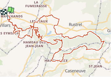
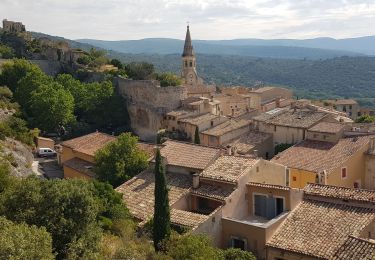
Tour Mountainbike von 39 km verfügbar auf Provence-Alpes-Côte d'Azur, Vaucluse, Villars. Diese Tour wird von tracegps vorgeschlagen.
Beschreibung
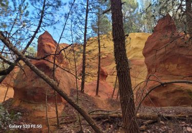
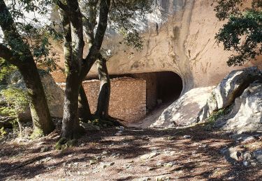
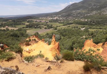
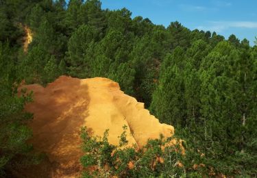
Un superbe parcours dans les orcres du colorado provencal, possibilité de réduire en 25 ou meme 15km. Un passage execptionnel dans une galerie de mine d ocre. Du pur bonheur pour les yeux, de beaux singles en descente et en montée.
Ort
Land:
France
Region :
Provence-Alpes-Côte d'Azur
Abteilung/Provinz :
Vaucluse
Kommune :
Villars
Standort:
Unknown
Gehen Sie:(Dec)
Gehen Sie:(UTM)
693276 ; 4866959 (31T) N.
Kommentare
Touren in der Umgebung
![Tour Wandern Villars - Chapelle st Pierre Aiguiers d' Auribeau - Photo](https://media.geolcdn.com/t/375/260/ext.jpg?maxdim=2&url=https%3A%2F%2Fstatic1.geolcdn.com%2Fsiteimages%2Fupload%2Ffiles%2F1553511878bg_sport_marche.png)
![Wandern Wandern](https://static1.geolcdn.com/sitytour/trail-icons/101.png)
Chapelle st Pierre Aiguiers d' Auribeau
Wandern
Einfach
(1)
Villars,
Provence-Alpes-Côte d'Azur,
Vaucluse,
France
![](/images/other/stat-length.png)
10,9 km | 17,8 km-effort
4h 43min
![](https://static1.geolcdn.com/siteimages/upload/files/16400158638029165_repeat_loop_refresh_sync_direction_icon.png)
Ja
![Tour Wandern Villars - correction villars auribeau - Photo](https://media.geolcdn.com/t/375/260/327e4e7a-d540-4609-af6e-f746d82ce16c.jpg&format=jpg&maxdim=2)
![Wandern Wandern](https://static1.geolcdn.com/sitytour/trail-icons/101.png)
correction villars auribeau
Wandern
Sehr schwierig
Villars,
Provence-Alpes-Côte d'Azur,
Vaucluse,
France
![](/images/other/stat-length.png)
14,3 km | 22 km-effort
5h 1min
![](https://static1.geolcdn.com/siteimages/upload/files/16400158638029165_repeat_loop_refresh_sync_direction_icon.png)
Ja
![Tour Wandern Saint-Saturnin-lès-Apt - Tour des Aiguiers-St Saturnin des Apt09-05-23 - Photo](https://media.geolcdn.com/t/375/260/d312fcbf-b0cf-4b76-815f-5442f1d28b2d.jpg&format=jpg&maxdim=2)
![Wandern Wandern](https://static1.geolcdn.com/sitytour/trail-icons/101.png)
Tour des Aiguiers-St Saturnin des Apt09-05-23
Wandern
Medium
Saint-Saturnin-lès-Apt,
Provence-Alpes-Côte d'Azur,
Vaucluse,
France
![](/images/other/stat-length.png)
12,1 km | 17,9 km-effort
3h 43min
![](https://static1.geolcdn.com/siteimages/upload/files/16400158638029165_repeat_loop_refresh_sync_direction_icon.png)
Ja
![Tour Wandern Saint-Saturnin-lès-Apt - APT S Saturnin d Apt , sentier des Auguiers et des bornes o - Photo](https://media.geolcdn.com/t/375/260/f4ec053c-09d8-429f-af97-5e267836d6e1.jpg&format=jpg&maxdim=2)
![Wandern Wandern](https://static1.geolcdn.com/sitytour/trail-icons/101.png)
APT S Saturnin d Apt , sentier des Auguiers et des bornes o
Wandern
Medium
Saint-Saturnin-lès-Apt,
Provence-Alpes-Côte d'Azur,
Vaucluse,
France
![](/images/other/stat-length.png)
15,2 km | 21 km-effort
4h 0min
![](https://static1.geolcdn.com/siteimages/upload/files/16400158638029165_repeat_loop_refresh_sync_direction_icon.png)
Ja
![Tour Wandern Villars - Les Aiguiers du Villars par Cabrone - Photo](https://media.geolcdn.com/t/375/260/e3a23535-df22-4f6f-b825-7ba3c861147b.jpg&format=jpg&maxdim=2)
![Wandern Wandern](https://static1.geolcdn.com/sitytour/trail-icons/101.png)
Les Aiguiers du Villars par Cabrone
Wandern
Schwierig
(1)
Villars,
Provence-Alpes-Côte d'Azur,
Vaucluse,
France
![](/images/other/stat-length.png)
17,7 km | 27 km-effort
4h 36min
![](https://static1.geolcdn.com/siteimages/upload/files/16400158638029165_repeat_loop_refresh_sync_direction_icon.png)
Ja
![Tour Wandern Saint-Saturnin-lès-Apt - st saturnin, les Aiguiers Grognards - Photo](https://media.geolcdn.com/t/375/260/0d35eb36-498f-4a8e-88e2-3e9aa73364c7.jpg&format=jpg&maxdim=2)
![Wandern Wandern](https://static1.geolcdn.com/sitytour/trail-icons/101.png)
st saturnin, les Aiguiers Grognards
Wandern
Schwierig
Saint-Saturnin-lès-Apt,
Provence-Alpes-Côte d'Azur,
Vaucluse,
France
![](/images/other/stat-length.png)
10,7 km | 17,5 km-effort
3h 8min
![](https://static1.geolcdn.com/siteimages/upload/files/16400158638029165_repeat_loop_refresh_sync_direction_icon.png)
Ja
![Tour Wandern Rustrel - Colorado Rustrel - Photo](https://media.geolcdn.com/t/375/260/068c088d-591e-4a28-a861-59ce458f7131.jpg&format=jpg&maxdim=2)
![Wandern Wandern](https://static1.geolcdn.com/sitytour/trail-icons/101.png)
Colorado Rustrel
Wandern
Sehr schwierig
Rustrel,
Provence-Alpes-Côte d'Azur,
Vaucluse,
France
![](/images/other/stat-length.png)
18,7 km | 25 km-effort
6h 2min
![](https://static1.geolcdn.com/siteimages/upload/files/16400158638029165_repeat_loop_refresh_sync_direction_icon.png)
Ja
![Tour Wandern Villars - Villars Colorado - Photo](https://media.geolcdn.com/t/375/260/ext.jpg?maxdim=2&url=https%3A%2F%2Fservices.sitytrail.com%2FGeolivesWS%2FDownloadMedia.ashx%3FTrailID%3D1042861%26Media%3Dfix__20180917103001.jpg)
![Wandern Wandern](https://static1.geolcdn.com/sitytour/trail-icons/101.png)
Villars Colorado
Wandern
Einfach
Villars,
Provence-Alpes-Côte d'Azur,
Vaucluse,
France
![](/images/other/stat-length.png)
3,3 km | 4,2 km-effort
54min
![](https://static1.geolcdn.com/siteimages/upload/files/16400158638029165_repeat_loop_refresh_sync_direction_icon.png)
Ja
![Tour Wandern Saint-Saturnin-lès-Apt - Sainte Radegonde - Photo](https://media.geolcdn.com/t/375/260/ext.jpg?maxdim=2&url=https%3A%2F%2Fservices.sitytrail.com%2FGeolivesWS%2FDownloadMedia.ashx%3FTrailID%3D698427%26Media%3Dfix__20170214180016.jpg)
![Wandern Wandern](https://static1.geolcdn.com/sitytour/trail-icons/101.png)
Sainte Radegonde
Wandern
Sehr leicht
(1)
Saint-Saturnin-lès-Apt,
Provence-Alpes-Côte d'Azur,
Vaucluse,
France
![](/images/other/stat-length.png)
4,2 km | 5,9 km-effort
1h 16min
![](https://static1.geolcdn.com/siteimages/upload/files/16400158638029165_repeat_loop_refresh_sync_direction_icon.png)
Ja
tour très sympa.
Peut être superbe mais il faut le matériel adéquat par temps de pluie ou sur terrains gras. Des parties de ruisseaux à traverser difficilement.