![](/images/other/stat-length.png)
![Tour Wandern Saint-Yon - St Yon - St Sulpice de Favières - Photo](https://media.geolcdn.com/t/1900/400/ext.pjpeg?maxdim=2&url=https%3A%2F%2Fservices.sitytrail.com%2FGeolivesWS%2FDownloadMedia.ashx%3FTrailID%3D101632%26Media%3D1815_2.jpg)
St Yon - St Sulpice de Favières
tracegps
Benutzer
![Länge](/images/other/stat-length.png)
Länge
11,9 km
![Maximale Höhe](https://static1.geolcdn.com/siteimages/upload/files/1508320355ic_sort_altitude_max_24dp.png)
Maximale Höhe
156 m
![Positive Höhendifferenz](https://static1.geolcdn.com/siteimages/upload/files/1508320355ic_sort_den_pos_24dp.png)
Positive Höhendifferenz
202 m
![Km-Effort](/images/other/stat-length.png)
Km-Effort
14,6 km
![Min. Höhe](https://static1.geolcdn.com/siteimages/upload/files/1508320355ic_sort_altitude_min_24dp.png)
Min. Höhe
57 m
![Negative Höhendifferenz](https://static1.geolcdn.com/siteimages/upload/files/1508320355ic_sort_den_neg_24dp.png)
Negative Höhendifferenz
216 m
![Boucle](https://static1.geolcdn.com/siteimages/upload/files/16400158638029165_repeat_loop_refresh_sync_direction_icon.png)
Boucle
Ja
Erstellungsdatum :
2014-12-10 00:00:00.0
Letzte Änderung :
2014-12-10 00:00:00.0
![Wandern](https://static1.geolcdn.com/sitytour/trail-icons/101.png)
3h00
Schwierigkeit : Medium
![Scannen Sie diesen QR-Code, um die Tour in der SityTrail-Anwendung zu öffnen](https://capi.geolives.com/qq0zvz2zws4bq2lad0pu/sitytour/trails/101632/qr.png?size=200)
Kostenlosegpshiking-Anwendung
Über SityTrail
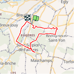
Tour Wandern von 11,9 km verfügbar auf Île-de-France, Essonne, Saint-Yon. Diese Tour wird von tracegps vorgeschlagen.
Beschreibung
Promenade de 12 km à travers village, bois, landes, rochers et vallée. Environ 3h00. D’autres informations et photos sont disponibles ICI
Ort
Land:
France
Region :
Île-de-France
Abteilung/Provinz :
Essonne
Kommune :
Saint-Yon
Standort:
Unknown
Gehen Sie:(Dec)
Gehen Sie:(UTM)
439695 ; 5378757 (31U) N.
Kommentare
Touren in der Umgebung
![Tour Wandern Saint-Sulpice-de-Favières - Les Pétales de Souzy - Photo](https://media.geolcdn.com/t/375/260/ext.jpg?maxdim=2&url=https%3A%2F%2Fservices.sitytrail.com%2FGeolivesWS%2FDownloadMedia.ashx%3FTrailID%3D110217%26Media%3D5477_1.jpg)
![Wandern Wandern](https://static1.geolcdn.com/sitytour/trail-icons/101.png)
Les Pétales de Souzy
Wandern
Schwierig
(1)
Saint-Sulpice-de-Favières,
Île-de-France,
Essonne,
France
![](/images/other/stat-length.png)
23 km | 29 km-effort
4h 49min
![](https://static1.geolcdn.com/siteimages/upload/files/16400158638029165_repeat_loop_refresh_sync_direction_icon.png)
Ja
![Tour Wandern Courson-Monteloup - Boucle au départ du château de Courson - Photo](https://media.geolcdn.com/t/375/260/ed11977b-20c0-4900-b0e3-aa6abed829d7.jpg&format=jpg&maxdim=2)
![Wandern Wandern](https://static1.geolcdn.com/sitytour/trail-icons/101.png)
Boucle au départ du château de Courson
Wandern
Einfach
Courson-Monteloup,
Île-de-France,
Essonne,
France
![](/images/other/stat-length.png)
23 km | 27 km-effort
5h 7min
![](https://static1.geolcdn.com/siteimages/upload/files/16400158638029165_repeat_loop_refresh_sync_direction_icon.png)
Ja
![Tour Wandern Arpajon - Linéaire Arpajon-Dourdan - Photo](https://media.geolcdn.com/t/375/260/ac693c75-5347-4379-a53b-f34a1ba4023c.jpg&format=jpg&maxdim=2)
![Wandern Wandern](https://static1.geolcdn.com/sitytour/trail-icons/101.png)
Linéaire Arpajon-Dourdan
Wandern
Schwierig
Arpajon,
Île-de-France,
Essonne,
France
![](/images/other/stat-length.png)
30 km | 35 km-effort
6h 13min
![](https://static1.geolcdn.com/siteimages/upload/files/16400158638029165_repeat_loop_refresh_sync_direction_icon.png)
Nein
![Tour Zu Fuß Saint-Sulpice-de-Favières - Boucle 18 km St Sulpice de Favières - Photo](https://media.geolcdn.com/t/375/260/d7c57897-6d36-438c-b5b4-66e9a4d71ed2.jpg&format=jpg&maxdim=2)
![Zu Fuß Zu Fuß](https://static1.geolcdn.com/sitytour/trail-icons/100.png)
Boucle 18 km St Sulpice de Favières
Zu Fuß
Medium
Saint-Sulpice-de-Favières,
Île-de-France,
Essonne,
France
![](/images/other/stat-length.png)
18 km | 22 km-effort
4h 59min
![](https://static1.geolcdn.com/siteimages/upload/files/16400158638029165_repeat_loop_refresh_sync_direction_icon.png)
Ja
![Tour Wandern Chamarande - bois de belvedere au depart de chamarande - Photo](https://media.geolcdn.com/t/375/260/ext.jpg?maxdim=2&url=https%3A%2F%2Fstatic1.geolcdn.com%2Fsiteimages%2Fupload%2Ffiles%2F1553511878bg_sport_marche.png)
![Wandern Wandern](https://static1.geolcdn.com/sitytour/trail-icons/101.png)
bois de belvedere au depart de chamarande
Wandern
Schwierig
(1)
Chamarande,
Île-de-France,
Essonne,
France
![](/images/other/stat-length.png)
12,6 km | 17,2 km-effort
3h 54min
![](https://static1.geolcdn.com/siteimages/upload/files/16400158638029165_repeat_loop_refresh_sync_direction_icon.png)
Ja
![Tour Wandern Saint-Maurice-Montcouronne - Boucle St Maurice Montcouronne - Brigitte - Photo](https://media.geolcdn.com/t/375/260/0e3ebb94-9c16-4bc9-9efb-ddbb902c3347.jpg&format=jpg&maxdim=2)
![Wandern Wandern](https://static1.geolcdn.com/sitytour/trail-icons/101.png)
Boucle St Maurice Montcouronne - Brigitte
Wandern
Sehr leicht
Saint-Maurice-Montcouronne,
Île-de-France,
Essonne,
France
![](/images/other/stat-length.png)
21 km | 24 km-effort
4h 19min
![](https://static1.geolcdn.com/siteimages/upload/files/16400158638029165_repeat_loop_refresh_sync_direction_icon.png)
Ja
![Tour Zu Fuß Saint-Yon - Sur les traces de la Renarde - Photo](https://media.geolcdn.com/t/375/260/422df56a-01d7-491a-a40b-c7b9da63fbd0.jpeg&format=jpg&maxdim=2)
![Zu Fuß Zu Fuß](https://static1.geolcdn.com/sitytour/trail-icons/100.png)
Sur les traces de la Renarde
Zu Fuß
Sehr schwierig
Saint-Yon,
Île-de-France,
Essonne,
France
![](/images/other/stat-length.png)
38 km | 44 km-effort
10h 4min
![](https://static1.geolcdn.com/siteimages/upload/files/16400158638029165_repeat_loop_refresh_sync_direction_icon.png)
Nein
![Tour Wandern Saint-Sulpice-de-Favières - St Sulpice - Photo](https://media.geolcdn.com/t/375/260/ext.jpg?maxdim=2&url=https%3A%2F%2Fstatic1.geolcdn.com%2Fsiteimages%2Fupload%2Ffiles%2F1553511878bg_sport_marche.png)
![Wandern Wandern](https://static1.geolcdn.com/sitytour/trail-icons/101.png)
St Sulpice
Wandern
Medium
(1)
Saint-Sulpice-de-Favières,
Île-de-France,
Essonne,
France
![](/images/other/stat-length.png)
8 km | 10,1 km-effort
2h 18min
![](https://static1.geolcdn.com/siteimages/upload/files/16400158638029165_repeat_loop_refresh_sync_direction_icon.png)
Ja
![Tour Wandern Boissy-sous-Saint-Yon - Carrière de Madagascar - Photo](https://media.geolcdn.com/t/375/260/ext.jpg?maxdim=2&url=https%3A%2F%2Fstatic1.geolcdn.com%2Fsiteimages%2Fupload%2Ffiles%2F1553511878bg_sport_marche.png)
![Wandern Wandern](https://static1.geolcdn.com/sitytour/trail-icons/101.png)
Carrière de Madagascar
Wandern
Sehr leicht
(1)
Boissy-sous-Saint-Yon,
Île-de-France,
Essonne,
France
![](/images/other/stat-length.png)
13,2 km | 16,5 km-effort
2h 59min
![](https://static1.geolcdn.com/siteimages/upload/files/16400158638029165_repeat_loop_refresh_sync_direction_icon.png)
Ja