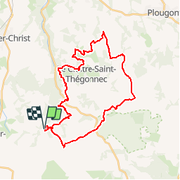
![](/images/other/stat-length.png)
![Tour Mountainbike Plounéour-Ménez - Espace VTT-FFC Morlaix Monts d'Arrée, circuit n°7 - Le Cloitre - Photo](https://media.geolcdn.com/t/1900/400/ext.pjpeg?maxdim=2&url=https%3A%2F%2Fservices.sitytrail.com%2FGeolivesWS%2FDownloadMedia.ashx%3FTrailID%3D101604%26Media%3D1793_2.jpg)
Espace VTT-FFC Morlaix Monts d'Arrée, circuit n°7 - Le Cloitre
tracegps
Benutzer
![Länge](/images/other/stat-length.png)
![Maximale Höhe](https://static1.geolcdn.com/siteimages/upload/files/1508320355ic_sort_altitude_max_24dp.png)
![Positive Höhendifferenz](https://static1.geolcdn.com/siteimages/upload/files/1508320355ic_sort_den_pos_24dp.png)
![Km-Effort](/images/other/stat-length.png)
![Min. Höhe](https://static1.geolcdn.com/siteimages/upload/files/1508320355ic_sort_altitude_min_24dp.png)
![Negative Höhendifferenz](https://static1.geolcdn.com/siteimages/upload/files/1508320355ic_sort_den_neg_24dp.png)
![Boucle](https://static1.geolcdn.com/siteimages/upload/files/16400158638029165_repeat_loop_refresh_sync_direction_icon.png)
![Mountainbike](https://static1.geolcdn.com/sitytour/trail-icons/202.png)
2h30
Schwierigkeit : Sehr schwierig
![Scannen Sie diesen QR-Code, um die Tour in der SityTrail-Anwendung zu öffnen](https://capi.geolives.com/qq0zvz2zws4bq2lad0pu/sitytour/trails/101604/qr.png?size=200)
Kostenlosegpshiking-Anwendung
Über SityTrail
Tour Mountainbike von 32 km verfügbar auf Bretagne, Finistère, Plounéour-Ménez. Diese Tour wird von tracegps vorgeschlagen.
Beschreibung
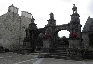
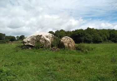
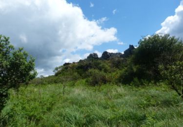
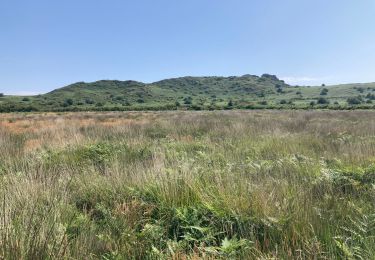
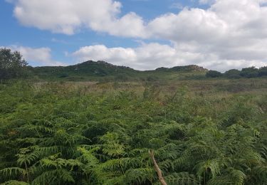
Espace VTT-FFC Morlaix Monts d’Arrée Circuit labellisé par la Fédération Française de Cyclisme. Au départ de l’Abbaye du Relec, ce circuit longe la ligne de crêtes des Monts d’Arrée où vivent les Korrigans : lutins bretons espiègles et farceurs. De nombreux points de vue vous font découvrir des paysages aussi diverses que grandioses.
Ort
Kommentare
Touren in der Umgebung
![Tour Zu Fuß Plounéour-Ménez - Circuit de la Montagne - Photo](https://media.geolcdn.com/t/375/260/c3130118-aa43-405b-bf06-303e6c5f1e74.jpeg&format=jpg&maxdim=2)
![Zu Fuß Zu Fuß](https://static1.geolcdn.com/sitytour/trail-icons/100.png)
Zu Fuß
![](/images/other/stat-length.png)
![](https://static1.geolcdn.com/siteimages/upload/files/16400158638029165_repeat_loop_refresh_sync_direction_icon.png)
![Tour Wandern Plounéour-Ménez - PLONÉOUR MENEZ - Photo](https://media.geolcdn.com/t/375/260/18747b60-836a-4fea-8d5e-afb0bfbc2f19.jpg&format=jpg&maxdim=2)
![Wandern Wandern](https://static1.geolcdn.com/sitytour/trail-icons/101.png)
Wandern
![](/images/other/stat-length.png)
![](https://static1.geolcdn.com/siteimages/upload/files/16400158638029165_repeat_loop_refresh_sync_direction_icon.png)
![Tour Wandern Plounéour-Ménez - Abbaye du Relec- Plounéour Ménez - Photo](https://media.geolcdn.com/t/375/260/ext.jpg?maxdim=2&url=https%3A%2F%2Fservices.sitytrail.com%2FGeolivesWS%2FDownloadMedia.ashx%3FTrailID%3D215232%26Media%3D15851_4.jpg)
![Wandern Wandern](https://static1.geolcdn.com/sitytour/trail-icons/101.png)
Wandern
![](/images/other/stat-length.png)
![](https://static1.geolcdn.com/siteimages/upload/files/16400158638029165_repeat_loop_refresh_sync_direction_icon.png)
![Tour Wandern Plounéour-Ménez - Roch Trévézel - Photo](https://media.geolcdn.com/t/375/260/e0c8cd47-ed65-4046-81b3-2ba2abd5191b.jpg&format=jpg&maxdim=2)
![Wandern Wandern](https://static1.geolcdn.com/sitytour/trail-icons/101.png)
Wandern
![](/images/other/stat-length.png)
![](https://static1.geolcdn.com/siteimages/upload/files/16400158638029165_repeat_loop_refresh_sync_direction_icon.png)
![Tour Wandern Berrien - BERRIEN - Photo](https://media.geolcdn.com/t/375/260/99e6cd0b-1e82-4917-b359-a604a63199d0.jpg&format=jpg&maxdim=2)
![Wandern Wandern](https://static1.geolcdn.com/sitytour/trail-icons/101.png)
![Tour Zu Fuß Berrien - Circuit de l'abbaye du Relec - Photo](https://media.geolcdn.com/t/375/260/2092cde2-aa91-4a91-8f69-04318fbe31bd.jpeg&format=jpg&maxdim=2)
![Zu Fuß Zu Fuß](https://static1.geolcdn.com/sitytour/trail-icons/100.png)
Zu Fuß
![](/images/other/stat-length.png)
![](https://static1.geolcdn.com/siteimages/upload/files/16400158638029165_repeat_loop_refresh_sync_direction_icon.png)
![Tour Wandern Le Cloître-Saint-Thégonnec - Kermorgant - Photo](https://media.geolcdn.com/t/375/260/a9724d5e-2feb-4a5f-9b2e-41ef03b50db1.jpg&format=jpg&maxdim=2)
![Wandern Wandern](https://static1.geolcdn.com/sitytour/trail-icons/101.png)
Wandern
![](/images/other/stat-length.png)
![](https://static1.geolcdn.com/siteimages/upload/files/16400158638029165_repeat_loop_refresh_sync_direction_icon.png)
![Tour Wandern Plounéour-Ménez - Balade de l'abbaye de Relecq - Photo](https://media.geolcdn.com/t/375/260/094260ee-59ef-4ea6-882a-8119688b51fa.jpg&format=jpg&maxdim=2)
![Wandern Wandern](https://static1.geolcdn.com/sitytour/trail-icons/101.png)
Wandern
![](/images/other/stat-length.png)
![](https://static1.geolcdn.com/siteimages/upload/files/16400158638029165_repeat_loop_refresh_sync_direction_icon.png)
![Tour Wandern Plounéour-Ménez - Espace VTT-FFC Morlaix Monts d'Arrée, circuit n°7 - Le Cloitre - Photo](https://media.geolcdn.com/t/375/260/ext.jpg?maxdim=2&url=https%3A%2F%2Fservices.sitytrail.com%2FGeolivesWS%2FDownloadMedia.ashx%3FTrailID%3D101603%26Media%3D1793_2.jpg)
![Wandern Wandern](https://static1.geolcdn.com/sitytour/trail-icons/101.png)
Wandern
![](/images/other/stat-length.png)
![](https://static1.geolcdn.com/siteimages/upload/files/16400158638029165_repeat_loop_refresh_sync_direction_icon.png)
Super parcours très varié à refaire première partie découverte des Landes seconde partie plus technique plus boisée plus Vtt .L ensemble faut un 4/5