![](/images/other/stat-length.png)
![Tour Mountainbike Bédarieux - Crête de Bédarieux - Photo](https://media.geolcdn.com/t/1900/400/ext.pjpeg?maxdim=2&url=https%3A%2F%2Fstatic1.geolcdn.com%2Fsiteimages%2Fupload%2Ffiles%2F1524743154velo.jpg)
Crête de Bédarieux
tracegps
Benutzer
![Länge](/images/other/stat-length.png)
Länge
15,8 km
![Maximale Höhe](https://static1.geolcdn.com/siteimages/upload/files/1508320355ic_sort_altitude_max_24dp.png)
Maximale Höhe
480 m
![Positive Höhendifferenz](https://static1.geolcdn.com/siteimages/upload/files/1508320355ic_sort_den_pos_24dp.png)
Positive Höhendifferenz
417 m
![Km-Effort](/images/other/stat-length.png)
Km-Effort
21 km
![Min. Höhe](https://static1.geolcdn.com/siteimages/upload/files/1508320355ic_sort_altitude_min_24dp.png)
Min. Höhe
175 m
![Negative Höhendifferenz](https://static1.geolcdn.com/siteimages/upload/files/1508320355ic_sort_den_neg_24dp.png)
Negative Höhendifferenz
417 m
![Boucle](https://static1.geolcdn.com/siteimages/upload/files/16400158638029165_repeat_loop_refresh_sync_direction_icon.png)
Boucle
Ja
Erstellungsdatum :
2014-12-10 00:00:00.0
Letzte Änderung :
2014-12-10 00:00:00.0
![Mountainbike](https://static1.geolcdn.com/sitytour/trail-icons/202.png)
2h00
Schwierigkeit : Medium
![Scannen Sie diesen QR-Code, um die Tour in der SityTrail-Anwendung zu öffnen](https://capi.geolives.com/qq0zvz2zws4bq2lad0pu/sitytour/trails/101548/qr.png?size=200)
Kostenlosegpshiking-Anwendung
Über SityTrail
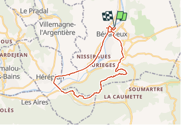
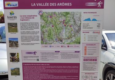
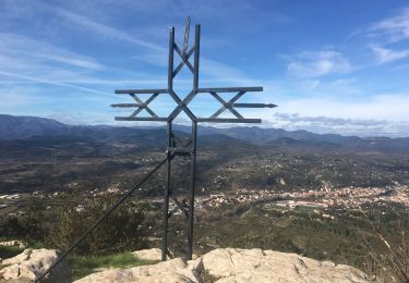
Tour Mountainbike von 15,8 km verfügbar auf Okzitanien, Hérault, Bédarieux. Diese Tour wird von tracegps vorgeschlagen.
Beschreibung
Petite boucle sympa sur les hauteurs de Bédarieux, un joli panorama de la région. Si vous avez un problème avec votre vélo, pensez à CYCLES HORIZON ( 13 AVENUE ABBE TARROUX - BEDARIEUX - Tél : 04.67.95.34.25), un bouclard sympa !
Ort
Land:
France
Region :
Okzitanien
Abteilung/Provinz :
Hérault
Kommune :
Bédarieux
Standort:
Unknown
Gehen Sie:(Dec)
Gehen Sie:(UTM)
512886 ; 4829540 (31T) N.
Kommentare
Touren in der Umgebung
![Tour Wandern Hérépian - herepian pic de Tantajo - Photo](https://media.geolcdn.com/t/375/260/ext.jpg?maxdim=2&url=https%3A%2F%2Fservices.sitytrail.com%2FGeolivesWS%2FDownloadMedia.ashx%3FTrailID%3D656804%26Media%3D20161106140841.jpg)
![Wandern Wandern](https://static1.geolcdn.com/sitytour/trail-icons/101.png)
herepian pic de Tantajo
Wandern
Einfach
(1)
Hérépian,
Okzitanien,
Hérault,
France
![](/images/other/stat-length.png)
13 km | 18,6 km-effort
4h 17min
![](https://static1.geolcdn.com/siteimages/upload/files/16400158638029165_repeat_loop_refresh_sync_direction_icon.png)
Ja
![Tour Fahrrad Villemagne-l'Argentière - bedarieux. Mons la trivale par la voie verte allé retour - Photo](https://media.geolcdn.com/t/375/260/ext.jpg?maxdim=2&url=https%3A%2F%2Fservices.sitytrail.com%2FGeolivesWS%2FDownloadMedia.ashx%3FTrailID%3D217102%26Media%3D20130827171314.jpg)
![Fahrrad Fahrrad](https://static1.geolcdn.com/sitytour/trail-icons/200.png)
bedarieux. Mons la trivale par la voie verte allé retour
Fahrrad
Sehr leicht
(2)
Villemagne-l'Argentière,
Okzitanien,
Hérault,
France
![](/images/other/stat-length.png)
31 km | 37 km-effort
3h 11min
![](https://static1.geolcdn.com/siteimages/upload/files/16400158638029165_repeat_loop_refresh_sync_direction_icon.png)
Nein
![Tour Wandern Les Aires - Saint Michel la coquillade - Photo](https://media.geolcdn.com/t/375/260/ext.jpg?maxdim=2&url=https%3A%2F%2Fservices.sitytrail.com%2FGeolivesWS%2FDownloadMedia.ashx%3FTrailID%3D419022%26Media%3Dfix__20150406153326.jpg)
![Wandern Wandern](https://static1.geolcdn.com/sitytour/trail-icons/101.png)
Saint Michel la coquillade
Wandern
Medium
(1)
Les Aires,
Okzitanien,
Hérault,
France
![](/images/other/stat-length.png)
13,2 km | 21 km-effort
4h 7min
![](https://static1.geolcdn.com/siteimages/upload/files/16400158638029165_repeat_loop_refresh_sync_direction_icon.png)
Ja
![Tour Wandern Hérépian - vallée des arômes - Photo](https://media.geolcdn.com/t/375/260/c6753d91-15fa-4844-b595-c6b7592a45cf.jpg&format=jpg&maxdim=2)
![Wandern Wandern](https://static1.geolcdn.com/sitytour/trail-icons/101.png)
vallée des arômes
Wandern
Medium
Hérépian,
Okzitanien,
Hérault,
France
![](/images/other/stat-length.png)
13,4 km | 17,4 km-effort
3h 11min
![](https://static1.geolcdn.com/siteimages/upload/files/16400158638029165_repeat_loop_refresh_sync_direction_icon.png)
Ja
![Tour Wandern Villemagne-l'Argentière - Boussagues - Photo](https://media.geolcdn.com/t/375/260/be08c2e4-1762-4385-aef6-316aec3868b5.jpg&format=jpg&maxdim=2)
![Wandern Wandern](https://static1.geolcdn.com/sitytour/trail-icons/101.png)
Boussagues
Wandern
Medium
Villemagne-l'Argentière,
Okzitanien,
Hérault,
France
![](/images/other/stat-length.png)
16 km | 22 km-effort
4h 30min
![](https://static1.geolcdn.com/siteimages/upload/files/16400158638029165_repeat_loop_refresh_sync_direction_icon.png)
Ja
![Tour Wandern Les Aires - les aires, chapelle Saint Michel - Photo](https://media.geolcdn.com/t/375/260/5794cff5-7317-4fba-a64f-d491ed24084c.jpg&format=jpg&maxdim=2)
![Wandern Wandern](https://static1.geolcdn.com/sitytour/trail-icons/101.png)
les aires, chapelle Saint Michel
Wandern
Medium
Les Aires,
Okzitanien,
Hérault,
France
![](/images/other/stat-length.png)
7,6 km | 11,4 km-effort
3h 25min
![](https://static1.geolcdn.com/siteimages/upload/files/16400158638029165_repeat_loop_refresh_sync_direction_icon.png)
Ja
![Tour Wandern Bédarieux - Moulins de faugeres - Photo](https://media.geolcdn.com/t/375/260/b3764dc8-fe17-44a1-b048-1c1d073310cb.jpg&format=jpg&maxdim=2)
![Wandern Wandern](https://static1.geolcdn.com/sitytour/trail-icons/101.png)
Moulins de faugeres
Wandern
Einfach
Bédarieux,
Okzitanien,
Hérault,
France
![](/images/other/stat-length.png)
13,3 km | 17,5 km-effort
3h 36min
![](https://static1.geolcdn.com/siteimages/upload/files/16400158638029165_repeat_loop_refresh_sync_direction_icon.png)
Ja
![Tour Wandern Faugères - La Caumette- Pic du Tantajo - Photo](https://media.geolcdn.com/t/375/260/a3bc5e44-6b9f-4ff4-a63f-d3f7e92231db.jpg&format=jpg&maxdim=2)
![Wandern Wandern](https://static1.geolcdn.com/sitytour/trail-icons/101.png)
La Caumette- Pic du Tantajo
Wandern
Schwierig
(1)
Faugères,
Okzitanien,
Hérault,
France
![](/images/other/stat-length.png)
13 km | 18,7 km-effort
4h 59min
![](https://static1.geolcdn.com/siteimages/upload/files/16400158638029165_repeat_loop_refresh_sync_direction_icon.png)
Ja
![Tour Wandern Les Aires - la coquillage et saint michel - Photo](https://media.geolcdn.com/t/375/260/2c99762b-b4fb-4a37-b9fb-706d8d94b4c4.jpg&format=jpg&maxdim=2)
![Wandern Wandern](https://static1.geolcdn.com/sitytour/trail-icons/101.png)
la coquillage et saint michel
Wandern
Medium
Les Aires,
Okzitanien,
Hérault,
France
![](/images/other/stat-length.png)
11,9 km | 19,7 km-effort
3h 47min
![](https://static1.geolcdn.com/siteimages/upload/files/16400158638029165_repeat_loop_refresh_sync_direction_icon.png)
Ja