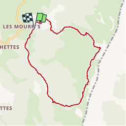
![](/images/other/stat-length.png)
![Tour Wandern Villard-de-Lans - Le Plateau du Cornafion 1906m - Photo](https://media.geolcdn.com/t/1900/400/ext.pjpeg?maxdim=2&url=https%3A%2F%2Fservices.sitytrail.com%2FGeolivesWS%2FDownloadMedia.ashx%3FTrailID%3D101491%26Media%3D1596_1.jpg)
Le Plateau du Cornafion 1906m
tracegps
Benutzer
![Länge](/images/other/stat-length.png)
![Maximale Höhe](https://static1.geolcdn.com/siteimages/upload/files/1508320355ic_sort_altitude_max_24dp.png)
![Positive Höhendifferenz](https://static1.geolcdn.com/siteimages/upload/files/1508320355ic_sort_den_pos_24dp.png)
![Km-Effort](/images/other/stat-length.png)
![Min. Höhe](https://static1.geolcdn.com/siteimages/upload/files/1508320355ic_sort_altitude_min_24dp.png)
![Negative Höhendifferenz](https://static1.geolcdn.com/siteimages/upload/files/1508320355ic_sort_den_neg_24dp.png)
![Boucle](https://static1.geolcdn.com/siteimages/upload/files/16400158638029165_repeat_loop_refresh_sync_direction_icon.png)
![Wandern](https://static1.geolcdn.com/sitytour/trail-icons/101.png)
4h30
Schwierigkeit : Schwierig
![Scannen Sie diesen QR-Code, um die Tour in der SityTrail-Anwendung zu öffnen](https://capi.geolives.com/qq0zvz2zws4bq2lad0pu/sitytour/trails/101491/qr.png?size=200)
Kostenlosegpshiking-Anwendung
Über SityTrail
Tour Wandern von 7,8 km verfügbar auf Auvergne-Rhone-Alpen, Isère, Villard-de-Lans. Diese Tour wird von tracegps vorgeschlagen.
Beschreibung
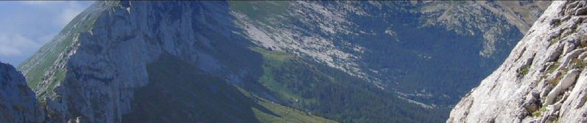
Du sommet du Roc de Cornafion, j'avais remarqué ce plateau herbeux imaginant l'ambiance de falaises qui devait y régner. Cela suffisait pour motiver cette sortie sauvage pourtant peu éloignée de Villard de Lans. Le topo d'Antoine Salvi servant de fil d'Ariane, je quittais la Conversaria en direction de la cabane de Roybon de bon matin pour ne pas souffrir de la chaleur et monter la raide croupe à l'ombre des falaises. Description complète sur sentier-nature.com : Le Plateau du Cornafion 1906m Certains passages de cet itinéraire de montagne sont escarpés et/ou très exposés, il est déconseillé aux enfants non accompagnés et aux personnes sujettes au vertige. Pour votre sécurité, nous vous invitons à respecter les règles suivantes : être bien chaussé, ne pas s'engager par mauvais temps, ne pas s'écarter de l'itinéraire ni des sentiers. Pour assurer les moins expérimentés, une corde d'une vingtaine de mètres peut être utile. Il apparaît souhaitable de réaliser cette course par temps sec. Cet itinéraire ce déroule tout ou partie dans la Réserve Naturelle des Hauts Plateaux du Vercors qui a pour mission d'étudier et de gérer ce territoire afin que les diverses activités qui s'y exercent (élevage, exploitation forestière, randonnée, etc.) soient compatibles avec la préservation de la faune, de la flore et du paysage. Participez à la protection de cet espace en respectant la règlementation.
Ort
Kommentare
Touren in der Umgebung
![Tour Wandern Lans-en-Vercors - 38 pic st michel - Photo](https://media.geolcdn.com/t/375/260/cfeb7787-6d5b-45db-91c6-1feb93d2f73c.jpg&format=jpg&maxdim=2)
![Wandern Wandern](https://static1.geolcdn.com/sitytour/trail-icons/101.png)
Wandern
![](/images/other/stat-length.png)
![](https://static1.geolcdn.com/siteimages/upload/files/16400158638029165_repeat_loop_refresh_sync_direction_icon.png)
![Tour Schneeschuhwandern Lans-en-Vercors - La Crête des Ramées de nuit en raquettes - Photo](https://media.geolcdn.com/t/375/260/ext.jpg?maxdim=2&url=https%3A%2F%2Fservices.sitytrail.com%2FGeolivesWS%2FDownloadMedia.ashx%3FTrailID%3D897155%26Media%3Dfix__20180130203527.jpg)
![Schneeschuhwandern Schneeschuhwandern](https://static1.geolcdn.com/sitytour/trail-icons/504.png)
Schneeschuhwandern
![](/images/other/stat-length.png)
![](https://static1.geolcdn.com/siteimages/upload/files/16400158638029165_repeat_loop_refresh_sync_direction_icon.png)
![Tour Wandern Villard-de-Lans - villard col des 2 soeurs - Photo](https://media.geolcdn.com/t/375/260/ext.jpg?maxdim=2&url=https%3A%2F%2Fservices.sitytrail.com%2FGeolivesWS%2FDownloadMedia.ashx%3FTrailID%3D453991%26Media%3Dfix__20150803124330.jpg)
![Wandern Wandern](https://static1.geolcdn.com/sitytour/trail-icons/101.png)
Wandern
![](/images/other/stat-length.png)
![](https://static1.geolcdn.com/siteimages/upload/files/16400158638029165_repeat_loop_refresh_sync_direction_icon.png)
![Tour Wandern Lans-en-Vercors - Le Pic saint michel - Photo](https://media.geolcdn.com/t/375/260/ext.jpg?maxdim=2&url=https%3A%2F%2Fservices.sitytrail.com%2FGeolivesWS%2FDownloadMedia.ashx%3FTrailID%3D205024%26Media%3Dfix__20130714151209.jpg)
![Wandern Wandern](https://static1.geolcdn.com/sitytour/trail-icons/101.png)
Wandern
![](/images/other/stat-length.png)
![](https://static1.geolcdn.com/siteimages/upload/files/16400158638029165_repeat_loop_refresh_sync_direction_icon.png)
![Tour Schneeschuhwandern Autrans-Méaudre en Vercors - Le Gros Martel - Méaudre - Photo](https://media.geolcdn.com/t/375/260/ext.jpg?maxdim=2&url=https%3A%2F%2Fservices.sitytrail.com%2FGeolivesWS%2FDownloadMedia.ashx%3FTrailID%3D191341%26Media%3D14899_5.jpg)
![Schneeschuhwandern Schneeschuhwandern](https://static1.geolcdn.com/sitytour/trail-icons/504.png)
Schneeschuhwandern
![](/images/other/stat-length.png)
![](https://static1.geolcdn.com/siteimages/upload/files/16400158638029165_repeat_loop_refresh_sync_direction_icon.png)
![Tour Wandern Lans-en-Vercors - le vertige des cimes - Photo](https://media.geolcdn.com/t/375/260/2d2e8455-1754-4db8-b9ed-75845d14fe6a.jpg&format=jpg&maxdim=2)
![Wandern Wandern](https://static1.geolcdn.com/sitytour/trail-icons/101.png)
Wandern
![](/images/other/stat-length.png)
![](https://static1.geolcdn.com/siteimages/upload/files/16400158638029165_repeat_loop_refresh_sync_direction_icon.png)
![Tour Wandern Villard-de-Lans - cabane de robon - Photo](https://media.geolcdn.com/t/375/260/f81b29b4-5a6d-4db9-85aa-f42275b30a70.jpg&format=jpg&maxdim=2)
![Wandern Wandern](https://static1.geolcdn.com/sitytour/trail-icons/101.png)
Wandern
![](/images/other/stat-length.png)
![](https://static1.geolcdn.com/siteimages/upload/files/16400158638029165_repeat_loop_refresh_sync_direction_icon.png)
![Tour Schneeschuhwandern Lans-en-Vercors - Le Pic Saint-Michel en raquettes (2012) - Photo](https://media.geolcdn.com/t/375/260/ext.jpg?maxdim=2&url=https%3A%2F%2Fservices.sitytrail.com%2FGeolivesWS%2FDownloadMedia.ashx%3FTrailID%3D107676%26Media%3D12680_1.jpg)
![Schneeschuhwandern Schneeschuhwandern](https://static1.geolcdn.com/sitytour/trail-icons/504.png)
Schneeschuhwandern
![](/images/other/stat-length.png)
![](https://static1.geolcdn.com/siteimages/upload/files/16400158638029165_repeat_loop_refresh_sync_direction_icon.png)
![Tour Mountainbike Corrençon-en-Vercors - Grande Traversée des PréAlpes à VTT : Corrençon en Vercors - La Chapelle en Vercors - Photo](https://media.geolcdn.com/t/375/260/ext.jpg?maxdim=2&url=https%3A%2F%2Fservices.sitytrail.com%2FGeolivesWS%2FDownloadMedia.ashx%3FTrailID%3D102135%26Media%3D2525_2.jpg)
![Mountainbike Mountainbike](https://static1.geolcdn.com/sitytour/trail-icons/202.png)
Mountainbike
![](/images/other/stat-length.png)
![](https://static1.geolcdn.com/siteimages/upload/files/16400158638029165_repeat_loop_refresh_sync_direction_icon.png)