


10,9 km | 14,5 km-effort

Benutzer


Kostenlosegpshiking-Anwendung
 SityTrail
IGN / Geografische Institute
SityTrail World
Die Welt öffnet sich für Sie
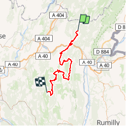
Tour Mountainbike von 76 km verfügbar auf Auvergne-Rhone-Alpen, Ain, Giron. Diese Tour wird von tracegps vorgeschlagen.
Itinéraire balisé de 380 km entre les Vosges au Nord et les Alpes au Sud, près de la Suisse à l’Est, la Grande Traversée du Jura est une classique de la randonnée itinérante à VTT. Labellisée par la Fédération Française de Cyclisme, la GTJ se pratique de mai à octobre et bénéficie d’un vaste réseau d’hébergements recevant les randonneurs à l’étape. La GTJ poursuit son périple vers le Sud et traverse les montagnes du Bugey, entre Haute Savoie et région lyonnaise. Il s’agit d’abord de franchir la cluse de Nantua, entre Giron et Le Poizat. Puis la traversée du plateau de Retord et le passage au Crêt du Nu (1350 m) proposera de larges panoramas sur les Alpes, alors que se profile la fin du voyage dans la petite station climatique d’Hauteville-Lompnes. Descriptif détaillé et informations pratiques : carto-guide VTT de la GTJ – éditions Chamina – tronçons 19 à 23.


Wandern

Wandern

Schneeschuhwandern
Wandern
Wandern
Wandern
Wandern
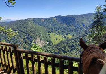
Reiten