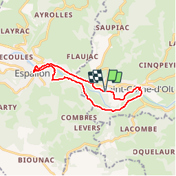
![](/images/other/stat-length.png)
![Tour Mountainbike Saint-Côme-d'Olt - St Côme D'Olt / Espalion Boucle VTT - Photo](https://media.geolcdn.com/t/1900/400/ext.pjpeg?maxdim=2&url=https%3A%2F%2Fstatic1.geolcdn.com%2Fsiteimages%2Fupload%2Ffiles%2F1524743154velo.jpg)
St Côme D'Olt / Espalion Boucle VTT
Strabidja
Benutzer
![Länge](/images/other/stat-length.png)
![Maximale Höhe](https://static1.geolcdn.com/siteimages/upload/files/1508320355ic_sort_altitude_max_24dp.png)
![Positive Höhendifferenz](https://static1.geolcdn.com/siteimages/upload/files/1508320355ic_sort_den_pos_24dp.png)
![Km-Effort](/images/other/stat-length.png)
![Min. Höhe](https://static1.geolcdn.com/siteimages/upload/files/1508320355ic_sort_altitude_min_24dp.png)
![Negative Höhendifferenz](https://static1.geolcdn.com/siteimages/upload/files/1508320355ic_sort_den_neg_24dp.png)
![Boucle](https://static1.geolcdn.com/siteimages/upload/files/16400158638029165_repeat_loop_refresh_sync_direction_icon.png)
![Mountainbike](https://static1.geolcdn.com/sitytour/trail-icons/202.png)
55m
Schwierigkeit : Einfach
![Scannen Sie diesen QR-Code, um die Tour in der SityTrail-Anwendung zu öffnen](https://capi.geolives.com/qq0zvz2zws4bq2lad0pu/sitytour/trails/1014503/qr.png?size=200)
Kostenlosegpshiking-Anwendung
Über SityTrail
Tour Mountainbike von 11,8 km verfügbar auf Okzitanien, Aveyron, Saint-Côme-d'Olt. Diese Tour wird von Strabidja vorgeschlagen.
Beschreibung
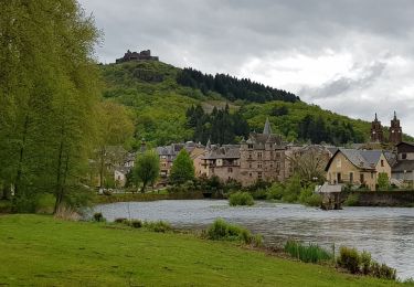
Petite boucle très sympa, qui part du château de Levinhac à St Côme d'Olt.
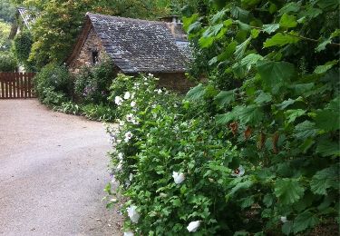
Grande partie par des petites routes, et quelques parties de sentier, chemin ou rives de la rivière, Lot.
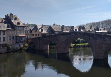
Vous passerez sur le vieux pont de St Côme d'Olt, puis suivrez une partie du GR65, chemin de St Jacques de Compostelle.
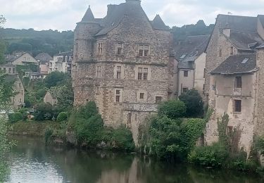
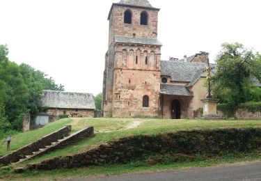
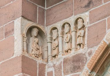
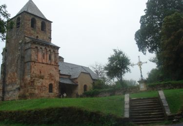
Ensuite vous trouverez sur votre route, la remarquable chapelle de Perse, pour ensuite rejoindre les rives du Lot d'où vous aurez une magnifique vue sur le vieux pont d'Espalion et son vieux palais.
Le point négatif est peut être le retour sur environ 2km sur la départementale depuis Espalion jusqu'à l'embranchement pour ; Levinhac/La Rame.
Bonne promenade à tous...
Ort
Kommentare
Touren in der Umgebung
![Tour Wandern Espalion - Compostelle 08 - Espalion -> Estaing - Photo](https://media.geolcdn.com/t/375/260/ext.jpg?maxdim=2&url=https%3A%2F%2Fservices.sitytrail.com%2FGeolivesWS%2FDownloadMedia.ashx%3FTrailID%3D442134%26Media%3D20120624142259.jpg)
![Wandern Wandern](https://static1.geolcdn.com/sitytour/trail-icons/101.png)
Wandern
![](/images/other/stat-length.png)
![](https://static1.geolcdn.com/siteimages/upload/files/16400158638029165_repeat_loop_refresh_sync_direction_icon.png)
![Tour Wandern Espalion - Espalion Massip Avril 2018 - Photo](https://media.geolcdn.com/t/375/260/ext.jpg?maxdim=2&url=https%3A%2F%2Fservices.sitytrail.com%2FGeolivesWS%2FDownloadMedia.ashx%3FTrailID%3D955009%26Media%3Dfix__20180424110415.jpg)
![Wandern Wandern](https://static1.geolcdn.com/sitytour/trail-icons/101.png)
Wandern
![](/images/other/stat-length.png)
![](https://static1.geolcdn.com/siteimages/upload/files/16400158638029165_repeat_loop_refresh_sync_direction_icon.png)
![Tour Wandern Espalion - AVEYRON ESPARIAT O - Photo](https://media.geolcdn.com/t/375/260/4565ad9c-3f8a-44cf-88d9-f429e395cd9c.jpg&format=jpg&maxdim=2)
![Wandern Wandern](https://static1.geolcdn.com/sitytour/trail-icons/101.png)
Wandern
![](/images/other/stat-length.png)
![](https://static1.geolcdn.com/siteimages/upload/files/16400158638029165_repeat_loop_refresh_sync_direction_icon.png)
![Tour Wandern Saint-Côme-d'Olt - étape st Jacques st come sur d olt-estaing - Photo](https://media.geolcdn.com/t/375/260/474b24f6-c6fb-4dc7-bd61-3496ab5d9373.jpg&format=jpg&maxdim=2)
![Wandern Wandern](https://static1.geolcdn.com/sitytour/trail-icons/101.png)
Wandern
![](/images/other/stat-length.png)
![](https://static1.geolcdn.com/siteimages/upload/files/16400158638029165_repeat_loop_refresh_sync_direction_icon.png)
![Tour Wandern Saint-Côme-d'Olt - saint Come d'Olt Estaing - Photo](https://media.geolcdn.com/t/375/260/c7fd43f8-31b2-462b-af01-373edc4bd2c8.jpg&format=jpg&maxdim=2)
![Wandern Wandern](https://static1.geolcdn.com/sitytour/trail-icons/101.png)
Wandern
![](/images/other/stat-length.png)
![](https://static1.geolcdn.com/siteimages/upload/files/16400158638029165_repeat_loop_refresh_sync_direction_icon.png)
![Tour Zu Fuß Espalion - La Voie du Rail - Photo](https://media.geolcdn.com/t/375/260/640990e0-ce63-48db-b0cb-2c1e1a59b13d.jpeg&format=jpg&maxdim=2)
![Zu Fuß Zu Fuß](https://static1.geolcdn.com/sitytour/trail-icons/100.png)
Zu Fuß
![](/images/other/stat-length.png)
![](https://static1.geolcdn.com/siteimages/upload/files/16400158638029165_repeat_loop_refresh_sync_direction_icon.png)
![Wandern Wandern](https://static1.geolcdn.com/sitytour/trail-icons/101.png)
Wandern
![](/images/other/stat-length.png)
![](https://static1.geolcdn.com/siteimages/upload/files/16400158638029165_repeat_loop_refresh_sync_direction_icon.png)
![Tour Wandern Saint-Côme-d'Olt - saint Côme d'olt- Estaing - Photo](https://media.geolcdn.com/t/375/260/573572db-bc00-4b76-94ac-152ed11426a7.jpg&format=jpg&maxdim=2)
![Wandern Wandern](https://static1.geolcdn.com/sitytour/trail-icons/101.png)
Wandern
![](/images/other/stat-length.png)
![](https://static1.geolcdn.com/siteimages/upload/files/16400158638029165_repeat_loop_refresh_sync_direction_icon.png)
![Tour Wandern Saint-Côme-d'Olt - Saint Côme d'Olt vers Estaing - Photo](https://media.geolcdn.com/t/375/260/ext.jpg?maxdim=2&url=https%3A%2F%2Fservices.sitytrail.com%2FGeolivesWS%2FDownloadMedia.ashx%3FTrailID%3D811193%26Media%3D20170816154701.jpg)
![Wandern Wandern](https://static1.geolcdn.com/sitytour/trail-icons/101.png)
Wandern
![](/images/other/stat-length.png)
![](https://static1.geolcdn.com/siteimages/upload/files/16400158638029165_repeat_loop_refresh_sync_direction_icon.png)