![](/images/other/stat-length.png)
![Tour Pferd Villandry - Villandry - Marnay par la Chatonnière - Photo](https://media.geolcdn.com/t/1900/400/ext.pjpeg?maxdim=2&url=https%3A%2F%2Fstatic1.geolcdn.com%2Fsiteimages%2Fupload%2Ffiles%2F1524743154cheval.jpg)
Villandry - Marnay par la Chatonnière
tracegps
Benutzer
![Länge](/images/other/stat-length.png)
Länge
26 km
![Maximale Höhe](https://static1.geolcdn.com/siteimages/upload/files/1508320355ic_sort_altitude_max_24dp.png)
Maximale Höhe
97 m
![Positive Höhendifferenz](https://static1.geolcdn.com/siteimages/upload/files/1508320355ic_sort_den_pos_24dp.png)
Positive Höhendifferenz
229 m
![Km-Effort](/images/other/stat-length.png)
Km-Effort
29 km
![Min. Höhe](https://static1.geolcdn.com/siteimages/upload/files/1508320355ic_sort_altitude_min_24dp.png)
Min. Höhe
34 m
![Negative Höhendifferenz](https://static1.geolcdn.com/siteimages/upload/files/1508320355ic_sort_den_neg_24dp.png)
Negative Höhendifferenz
229 m
![Boucle](https://static1.geolcdn.com/siteimages/upload/files/16400158638029165_repeat_loop_refresh_sync_direction_icon.png)
Boucle
Ja
Erstellungsdatum :
2014-12-10 00:00:00.0
Letzte Änderung :
2014-12-10 00:00:00.0
![Pferd](https://static1.geolcdn.com/sitytour/trail-icons/300.png)
6h00
Schwierigkeit : Medium
![Scannen Sie diesen QR-Code, um die Tour in der SityTrail-Anwendung zu öffnen](https://capi.geolives.com/qq0zvz2zws4bq2lad0pu/sitytour/trails/101425/qr.png?size=200)
Kostenlosegpshiking-Anwendung
Über SityTrail
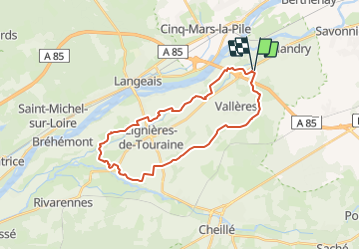
Tour Pferd von 26 km verfügbar auf Zentrum-Loiretal, Indre-et-Loire, Villandry. Diese Tour wird von tracegps vorgeschlagen.
Beschreibung
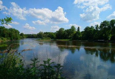
Boucle à faire à cheval entre Villandry et Marnay Très belle vue sur les jardins de la Chatonnière. Départ / arrivée depuis le Centre Equestre l'Alezane. Plus d'informations sur le site Stars-Trec
Ort
Land:
France
Region :
Zentrum-Loiretal
Abteilung/Provinz :
Indre-et-Loire
Kommune :
Villandry
Standort:
Unknown
Gehen Sie:(Dec)
Gehen Sie:(UTM)
310150 ; 5244762 (31T) N.
Kommentare
Touren in der Umgebung
![Tour Wandern Savonnières - Saveniére - Photo](https://media.geolcdn.com/t/375/260/ext.jpg?maxdim=2&url=https%3A%2F%2Fmedia.geolcdn.com%2Ff%2F7fdcd4e0-67c0-425e-8138-ba6c61518d59.jpg)
![Wandern Wandern](https://static1.geolcdn.com/sitytour/trail-icons/101.png)
Saveniére
Wandern
Medium
Savonnières,
Zentrum-Loiretal,
Indre-et-Loire,
France
![](/images/other/stat-length.png)
5,8 km | 6,9 km-effort
1h 38min
![](https://static1.geolcdn.com/siteimages/upload/files/16400158638029165_repeat_loop_refresh_sync_direction_icon.png)
Nein
![Tour Zu Fuß Villandry - Villandry - Photo](https://media.geolcdn.com/t/375/260/ext.jpg?maxdim=2&url=https%3A%2F%2Fmedia.geolcdn.com%2Ff%2F2738ba84-8de4-4d05-ae63-1f5216266cc4.jpg)
![Zu Fuß Zu Fuß](https://static1.geolcdn.com/sitytour/trail-icons/100.png)
Villandry
Zu Fuß
Medium
(1)
Villandry,
Zentrum-Loiretal,
Indre-et-Loire,
France
![](/images/other/stat-length.png)
22 km | 24 km-effort
Unbekannt
![](https://static1.geolcdn.com/siteimages/upload/files/16400158638029165_repeat_loop_refresh_sync_direction_icon.png)
Ja
![Tour Wandern Villandry - villandry - Photo](https://media.geolcdn.com/t/375/260/ext.jpg?maxdim=2&url=https%3A%2F%2Fservices.sitytrail.com%2FGeolivesWS%2FDownloadMedia.ashx%3FTrailID%3D336839%26Media%3Dfix__20140816103005.jpg)
![Wandern Wandern](https://static1.geolcdn.com/sitytour/trail-icons/101.png)
villandry
Wandern
Sehr leicht
Villandry,
Zentrum-Loiretal,
Indre-et-Loire,
France
![](/images/other/stat-length.png)
11,3 km | 12,7 km-effort
2h 18min
![](https://static1.geolcdn.com/siteimages/upload/files/16400158638029165_repeat_loop_refresh_sync_direction_icon.png)
Ja
![Tour Wandern Villandry - A L'Orée Du Chateau De Villandry - Photo](https://media.geolcdn.com/t/375/260/ext.jpg?maxdim=2&url=https%3A%2F%2Fservices.sitytrail.com%2FGeolivesWS%2FDownloadMedia.ashx%3FTrailID%3D127349%26Media%3Dfc5e3812-7415-49c5-a44e-fb43f15456a9.jpg)
![Wandern Wandern](https://static1.geolcdn.com/sitytour/trail-icons/101.png)
A L'Orée Du Chateau De Villandry
Wandern
Einfach
Villandry,
Zentrum-Loiretal,
Indre-et-Loire,
France
![](/images/other/stat-length.png)
11,6 km | 13 km-effort
2h 15min
![](https://static1.geolcdn.com/siteimages/upload/files/16400158638029165_repeat_loop_refresh_sync_direction_icon.png)
Ja
![Tour Pferd Villandry - Autour de Vallères - Photo](https://media.geolcdn.com/t/375/260/ext.jpg?maxdim=2&url=https%3A%2F%2Fservices.sitytrail.com%2FGeolivesWS%2FDownloadMedia.ashx%3FTrailID%3D103183%26Media%3D5023_1.jpg)
![Pferd Pferd](https://static1.geolcdn.com/sitytour/trail-icons/300.png)
Autour de Vallères
Pferd
Medium
Villandry,
Zentrum-Loiretal,
Indre-et-Loire,
France
![](/images/other/stat-length.png)
9,3 km | 10,8 km-effort
2h 30min
![](https://static1.geolcdn.com/siteimages/upload/files/16400158638029165_repeat_loop_refresh_sync_direction_icon.png)
Ja
![Tour Pferd Villandry - Château de Villandry - Photo](https://media.geolcdn.com/t/375/260/ext.jpg?maxdim=2&url=https%3A%2F%2Fservices.sitytrail.com%2FGeolivesWS%2FDownloadMedia.ashx%3FTrailID%3D103182%26Media%3D5022_1.jpg)
![Pferd Pferd](https://static1.geolcdn.com/sitytour/trail-icons/300.png)
Château de Villandry
Pferd
Medium
Villandry,
Zentrum-Loiretal,
Indre-et-Loire,
France
![](/images/other/stat-length.png)
12,8 km | 14,6 km-effort
3h 0min
![](https://static1.geolcdn.com/siteimages/upload/files/16400158638029165_repeat_loop_refresh_sync_direction_icon.png)
Ja
![Tour Pferd Villandry - Boucle à Vallères - Photo](https://media.geolcdn.com/t/375/260/ext.jpg?maxdim=2&url=https%3A%2F%2Fservices.sitytrail.com%2FGeolivesWS%2FDownloadMedia.ashx%3FTrailID%3D103161%26Media%3D4978_1.jpg)
![Pferd Pferd](https://static1.geolcdn.com/sitytour/trail-icons/300.png)
Boucle à Vallères
Pferd
Medium
Villandry,
Zentrum-Loiretal,
Indre-et-Loire,
France
![](/images/other/stat-length.png)
6,5 km | 7,6 km-effort
1h 30min
![](https://static1.geolcdn.com/siteimages/upload/files/16400158638029165_repeat_loop_refresh_sync_direction_icon.png)
Ja
![Tour Pferd Villandry - Les bords de Loire - Villandry - Photo](https://media.geolcdn.com/t/375/260/ext.jpg?maxdim=2&url=https%3A%2F%2Fservices.sitytrail.com%2FGeolivesWS%2FDownloadMedia.ashx%3FTrailID%3D103160%26Media%3D4977_1.jpg)
![Pferd Pferd](https://static1.geolcdn.com/sitytour/trail-icons/300.png)
Les bords de Loire - Villandry
Pferd
Medium
Villandry,
Zentrum-Loiretal,
Indre-et-Loire,
France
![](/images/other/stat-length.png)
12,3 km | 14 km-effort
3h 0min
![](https://static1.geolcdn.com/siteimages/upload/files/16400158638029165_repeat_loop_refresh_sync_direction_icon.png)
Ja
![Tour Mountainbike Cinq-Mars-la-Pile - Cinq Mars la Pile, Maziéres de Touraine, Langeais - Photo](https://media.geolcdn.com/t/375/260/ext.jpg?maxdim=2&url=https%3A%2F%2Fservices.sitytrail.com%2FGeolivesWS%2FDownloadMedia.ashx%3FTrailID%3D101417%26Media%3D1378_1.jpg)
![Mountainbike Mountainbike](https://static1.geolcdn.com/sitytour/trail-icons/202.png)
Cinq Mars la Pile, Maziéres de Touraine, Langeais
Mountainbike
Schwierig
Cinq-Mars-la-Pile,
Zentrum-Loiretal,
Indre-et-Loire,
France
![](/images/other/stat-length.png)
26 km | 31 km-effort
1h 45min
![](https://static1.geolcdn.com/siteimages/upload/files/16400158638029165_repeat_loop_refresh_sync_direction_icon.png)
Ja