![](/images/other/stat-length.png)
![Tour Mountainbike Rots - Cora 2007 - Chateau de Creully - Photo](https://media.geolcdn.com/t/1900/400/ext.pjpeg?maxdim=2&url=https%3A%2F%2Fstatic1.geolcdn.com%2Fsiteimages%2Fupload%2Ffiles%2F1524743154velo.jpg)
Cora 2007 - Chateau de Creully
tracegps
Benutzer
![Länge](/images/other/stat-length.png)
Länge
39 km
![Maximale Höhe](https://static1.geolcdn.com/siteimages/upload/files/1508320355ic_sort_altitude_max_24dp.png)
Maximale Höhe
70 m
![Positive Höhendifferenz](https://static1.geolcdn.com/siteimages/upload/files/1508320355ic_sort_den_pos_24dp.png)
Positive Höhendifferenz
336 m
![Km-Effort](/images/other/stat-length.png)
Km-Effort
43 km
![Min. Höhe](https://static1.geolcdn.com/siteimages/upload/files/1508320355ic_sort_altitude_min_24dp.png)
Min. Höhe
7 m
![Negative Höhendifferenz](https://static1.geolcdn.com/siteimages/upload/files/1508320355ic_sort_den_neg_24dp.png)
Negative Höhendifferenz
337 m
![Boucle](https://static1.geolcdn.com/siteimages/upload/files/16400158638029165_repeat_loop_refresh_sync_direction_icon.png)
Boucle
Ja
Erstellungsdatum :
2014-12-10 00:00:00.0
Letzte Änderung :
2014-12-10 00:00:00.0
![Mountainbike](https://static1.geolcdn.com/sitytour/trail-icons/202.png)
2h30
Schwierigkeit : Medium
![Scannen Sie diesen QR-Code, um die Tour in der SityTrail-Anwendung zu öffnen](https://capi.geolives.com/qq0zvz2zws4bq2lad0pu/sitytour/trails/101413/qr.png?size=200)
Kostenlosegpshiking-Anwendung
Über SityTrail
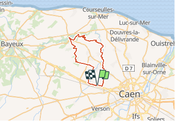
Tour Mountainbike von 39 km verfügbar auf Normandie, Calvados, Rots. Diese Tour wird von tracegps vorgeschlagen.
Beschreibung
Circuit de la rando organisée par le magasin Cora au profit de la SNSM (société nationale de sauvetage en mer) Ravito prévu dans la cour du Chateau de Creully.
Ort
Land:
France
Region :
Normandie
Abteilung/Provinz :
Calvados
Kommune :
Rots
Standort:
Rots
Gehen Sie:(Dec)
Gehen Sie:(UTM)
685016 ; 5452594 (30U) N.
Kommentare
Touren in der Umgebung
![Tour sport Rots - Lasson5 - Photo](https://media.geolcdn.com/t/375/260/ext.jpg?maxdim=2&url=https%3A%2F%2Fsecurestorage.geolives.com%2Fsitytour%2Ftrail-bg%2Fdefault.jpg)
Lasson5
sport
Sehr leicht
(1)
Rots,
Normandie,
Calvados,
France
![](/images/other/stat-length.png)
6,8 km | 7,4 km-effort
Unbekannt
![](https://static1.geolcdn.com/siteimages/upload/files/16400158638029165_repeat_loop_refresh_sync_direction_icon.png)
Nein
![Tour sport Rots - Secqueville5 - Photo](https://media.geolcdn.com/t/375/260/ext.jpg?maxdim=2&url=https%3A%2F%2Fsecurestorage.geolives.com%2Fsitytour%2Ftrail-bg%2Fdefault.jpg)
Secqueville5
sport
Sehr leicht
(1)
Rots,
Normandie,
Calvados,
France
![](/images/other/stat-length.png)
5,2 km | 5,6 km-effort
Unbekannt
![](https://static1.geolcdn.com/siteimages/upload/files/16400158638029165_repeat_loop_refresh_sync_direction_icon.png)
Nein
![Tour Wandern Bretteville-sur-Odon - Bretteville-s-Odon - Photo](https://media.geolcdn.com/t/375/260/ext.jpg?maxdim=2&url=https%3A%2F%2Fstatic1.geolcdn.com%2Fsiteimages%2Fupload%2Ffiles%2F1553511878bg_sport_marche.png)
![Wandern Wandern](https://static1.geolcdn.com/sitytour/trail-icons/101.png)
Bretteville-s-Odon
Wandern
Einfach
(1)
Bretteville-sur-Odon,
Normandie,
Calvados,
France
![](/images/other/stat-length.png)
6 km | 6,5 km-effort
1h 27min
![](https://static1.geolcdn.com/siteimages/upload/files/16400158638029165_repeat_loop_refresh_sync_direction_icon.png)
Ja
![Tour sport Cairon - Départ Cairon - Photo](https://media.geolcdn.com/t/375/260/61fb0b0c-557a-44e4-acfe-22e142ce8489.jpg&format=jpg&maxdim=2)
Départ Cairon
sport
Sehr leicht
Cairon,
Normandie,
Calvados,
France
![](/images/other/stat-length.png)
14,1 km | 15,9 km-effort
Unbekannt
![](https://static1.geolcdn.com/siteimages/upload/files/16400158638029165_repeat_loop_refresh_sync_direction_icon.png)
Ja
![Tour Wandern Cairon - cairon annick - Photo](https://media.geolcdn.com/t/375/260/ext.jpg?maxdim=2&url=https%3A%2F%2Fstatic1.geolcdn.com%2Fsiteimages%2Fupload%2Ffiles%2F1553511878bg_sport_marche.png)
![Wandern Wandern](https://static1.geolcdn.com/sitytour/trail-icons/101.png)
![Tour Mountainbike Cairon - Cairon-la mer - Photo](https://media.geolcdn.com/t/375/260/ext.jpg?maxdim=2&url=https%3A%2F%2Fstatic1.geolcdn.com%2Fsiteimages%2Fupload%2Ffiles%2F1524743154velo.jpg)
![Mountainbike Mountainbike](https://static1.geolcdn.com/sitytour/trail-icons/202.png)
Cairon-la mer
Mountainbike
Sehr schwierig
Cairon,
Normandie,
Calvados,
France
![](/images/other/stat-length.png)
46 km | 50 km-effort
4h 24min
![](https://static1.geolcdn.com/siteimages/upload/files/16400158638029165_repeat_loop_refresh_sync_direction_icon.png)
Ja
![Tour Wandern Thue et Mue - Bretteville - Photo](https://media.geolcdn.com/t/375/260/ext.jpg?maxdim=2&url=https%3A%2F%2Fstatic1.geolcdn.com%2Fsiteimages%2Fupload%2Ffiles%2F1553511878bg_sport_marche.png)
![Wandern Wandern](https://static1.geolcdn.com/sitytour/trail-icons/101.png)
Bretteville
Wandern
Sehr leicht
Thue et Mue,
Normandie,
Calvados,
France
![](/images/other/stat-length.png)
3,2 km | 3,4 km-effort
1h 4min
![](https://static1.geolcdn.com/siteimages/upload/files/16400158638029165_repeat_loop_refresh_sync_direction_icon.png)
Ja
![Tour Wandern Rots - Secqueville En Bessin (Vallée de la Thue) - Photo](https://media.geolcdn.com/t/375/260/ext.jpg?maxdim=2&url=https%3A%2F%2Fstatic1.geolcdn.com%2Fsiteimages%2Fupload%2Ffiles%2F1553511878bg_sport_marche.png)
![Wandern Wandern](https://static1.geolcdn.com/sitytour/trail-icons/101.png)
Secqueville En Bessin (Vallée de la Thue)
Wandern
Sehr leicht
Rots,
Normandie,
Calvados,
France
![](/images/other/stat-length.png)
10,5 km | 12 km-effort
3h 20min
![](https://static1.geolcdn.com/siteimages/upload/files/16400158638029165_repeat_loop_refresh_sync_direction_icon.png)
Ja
![Tour Nordic Walking Rots - rots Masson 11,5 kms - Photo](https://media.geolcdn.com/t/375/260/ext.jpg?maxdim=2&url=https%3A%2F%2Fstatic1.geolcdn.com%2Fsiteimages%2Fupload%2Ffiles%2F1545311037marcheuse_200dpi.jpg)
![Nordic Walking Nordic Walking](https://static1.geolcdn.com/sitytour/trail-icons/102.png)
rots Masson 11,5 kms
Nordic Walking
Einfach
Rots,
Normandie,
Calvados,
France
![](/images/other/stat-length.png)
12,2 km | 13,2 km-effort
2h 56min
![](https://static1.geolcdn.com/siteimages/upload/files/16400158638029165_repeat_loop_refresh_sync_direction_icon.png)
Ja