![](/images/other/stat-length.png)
![Tour Wandern Castelnaud-la-Chapelle - Les Milandes - St-Cybranet - Photo](https://media.geolcdn.com/t/1900/400/ext.pjpeg?maxdim=2&url=https%3A%2F%2Fservices.sitytrail.com%2FGeolivesWS%2FDownloadMedia.ashx%3FTrailID%3D101307%26Media%3D802_1.jpg)
Les Milandes - St-Cybranet
tracegps
Benutzer
![Länge](/images/other/stat-length.png)
Länge
14,2 km
![Maximale Höhe](https://static1.geolcdn.com/siteimages/upload/files/1508320355ic_sort_altitude_max_24dp.png)
Maximale Höhe
260 m
![Positive Höhendifferenz](https://static1.geolcdn.com/siteimages/upload/files/1508320355ic_sort_den_pos_24dp.png)
Positive Höhendifferenz
298 m
![Km-Effort](/images/other/stat-length.png)
Km-Effort
18,3 km
![Min. Höhe](https://static1.geolcdn.com/siteimages/upload/files/1508320355ic_sort_altitude_min_24dp.png)
Min. Höhe
76 m
![Negative Höhendifferenz](https://static1.geolcdn.com/siteimages/upload/files/1508320355ic_sort_den_neg_24dp.png)
Negative Höhendifferenz
334 m
![Boucle](https://static1.geolcdn.com/siteimages/upload/files/16400158638029165_repeat_loop_refresh_sync_direction_icon.png)
Boucle
Nein
Erstellungsdatum :
2014-12-10 00:00:00.0
Letzte Änderung :
2014-12-10 00:00:00.0
![Wandern](https://static1.geolcdn.com/sitytour/trail-icons/101.png)
3h00
Schwierigkeit : Medium
![Scannen Sie diesen QR-Code, um die Tour in der SityTrail-Anwendung zu öffnen](https://capi.geolives.com/qq0zvz2zws4bq2lad0pu/sitytour/trails/101307/qr.png?size=200)
Kostenlosegpshiking-Anwendung
Über SityTrail
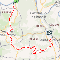
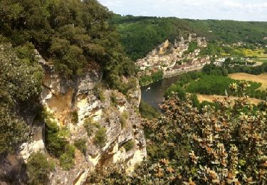
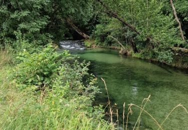
Tour Wandern von 14,2 km verfügbar auf Neu-Aquitanien, Dordogne, Castelnaud-la-Chapelle. Diese Tour wird von tracegps vorgeschlagen.
Beschreibung
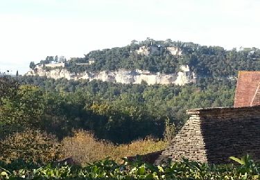
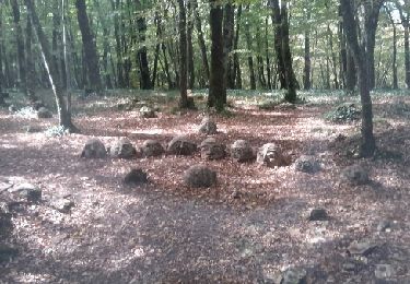
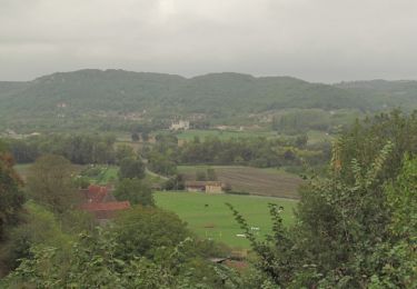
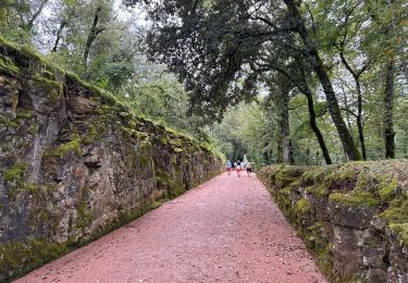
Petite balade linéaire (prévoir le retour) sur les côteaux de la vallée de la Dordogne et du Céou. D’autres infos sur le site Rando.eu Voir le site du Chateau des Milandes
Ort
Land:
France
Region :
Neu-Aquitanien
Abteilung/Provinz :
Dordogne
Kommune :
Castelnaud-la-Chapelle
Standort:
Unknown
Gehen Sie:(Dec)
Gehen Sie:(UTM)
350860 ; 4965021 (31T) N.
Kommentare
Touren in der Umgebung
![Tour Wandern Castelnaud-la-Chapelle - Castelnaud 14,5km - Photo](https://media.geolcdn.com/t/375/260/ext.jpg?maxdim=2&url=https%3A%2F%2Fservices.sitytrail.com%2FGeolivesWS%2FDownloadMedia.ashx%3FTrailID%3D1066189%26Media%3Dfix__20181103150326.jpg)
![Wandern Wandern](https://static1.geolcdn.com/sitytour/trail-icons/101.png)
Castelnaud 14,5km
Wandern
Medium
(1)
Castelnaud-la-Chapelle,
Neu-Aquitanien,
Dordogne,
France
![](/images/other/stat-length.png)
14,3 km | 18,3 km-effort
3h 41min
![](https://static1.geolcdn.com/siteimages/upload/files/16400158638029165_repeat_loop_refresh_sync_direction_icon.png)
Ja
![Tour Wandern Castelnaud-la-Chapelle - Périgord j2 Castelnaud - Photo](https://media.geolcdn.com/t/375/260/24da01e3-51b4-4959-999d-053c9737dbd0.jpg&format=jpg&maxdim=2)
![Wandern Wandern](https://static1.geolcdn.com/sitytour/trail-icons/101.png)
Périgord j2 Castelnaud
Wandern
Einfach
Castelnaud-la-Chapelle,
Neu-Aquitanien,
Dordogne,
France
![](/images/other/stat-length.png)
17,1 km | 24 km-effort
4h 38min
![](https://static1.geolcdn.com/siteimages/upload/files/16400158638029165_repeat_loop_refresh_sync_direction_icon.png)
Nein
![Tour Wandern Vézac - Boucle Beynac- La Roque Gageac - Photo](https://media.geolcdn.com/t/375/260/c8a62bb6-456c-4421-8ac7-a6b4d58db5d2.jpg&format=jpg&maxdim=2)
![Wandern Wandern](https://static1.geolcdn.com/sitytour/trail-icons/101.png)
Boucle Beynac- La Roque Gageac
Wandern
Medium
Vézac,
Neu-Aquitanien,
Dordogne,
France
![](/images/other/stat-length.png)
16,3 km | 22 km-effort
4h 20min
![](https://static1.geolcdn.com/siteimages/upload/files/16400158638029165_repeat_loop_refresh_sync_direction_icon.png)
Ja
![Tour Wandern Beynac-et-Cazenac - Perigor Beynac - Photo](https://media.geolcdn.com/t/375/260/a861afd5-735a-473e-a5f1-3f79378bc8ab.jpg&format=jpg&maxdim=2)
![Wandern Wandern](https://static1.geolcdn.com/sitytour/trail-icons/101.png)
Perigor Beynac
Wandern
Medium
Beynac-et-Cazenac,
Neu-Aquitanien,
Dordogne,
France
![](/images/other/stat-length.png)
16,3 km | 22 km-effort
4h 5min
![](https://static1.geolcdn.com/siteimages/upload/files/16400158638029165_repeat_loop_refresh_sync_direction_icon.png)
Ja
![Tour Motor Vézac - Jardin du château de Marquesac - Photo](https://media.geolcdn.com/t/375/260/ext.jpg?maxdim=2&url=https%3A%2F%2Fservices.sitytrail.com%2FGeolivesWS%2FDownloadMedia.ashx%3FTrailID%3D347730%26Media%3Dfix__20140923141715.jpg)
![Motor Motor](https://static1.geolcdn.com/sitytour/trail-icons/400.png)
Jardin du château de Marquesac
Motor
Sehr schwierig
Vézac,
Neu-Aquitanien,
Dordogne,
France
![](/images/other/stat-length.png)
5,3 km | 6,8 km-effort
4h 19min
![](https://static1.geolcdn.com/siteimages/upload/files/16400158638029165_repeat_loop_refresh_sync_direction_icon.png)
Ja
![Tour Wandern Castelnaud-la-Chapelle - Balade autour de Castelnaud la Chapelle - Photo](https://media.geolcdn.com/t/375/260/ext.jpg?maxdim=2&url=https%3A%2F%2Fservices.sitytrail.com%2FGeolivesWS%2FDownloadMedia.ashx%3FTrailID%3D172935%26Media%3D14412_3.jpg)
![Wandern Wandern](https://static1.geolcdn.com/sitytour/trail-icons/101.png)
Balade autour de Castelnaud la Chapelle
Wandern
Medium
Castelnaud-la-Chapelle,
Neu-Aquitanien,
Dordogne,
France
![](/images/other/stat-length.png)
13,5 km | 19 km-effort
3h 30min
![](https://static1.geolcdn.com/siteimages/upload/files/16400158638029165_repeat_loop_refresh_sync_direction_icon.png)
Ja
![Tour Wandern Vézac - 2011-06-03 - 17h56m53 - Photo](https://media.geolcdn.com/t/375/260/ext.jpg?maxdim=2&url=https%3A%2F%2Fservices.sitytrail.com%2FGeolivesWS%2FDownloadMedia.ashx%3FTrailID%3D67099%26Media%3D20110603154850.jpg)
![Wandern Wandern](https://static1.geolcdn.com/sitytour/trail-icons/101.png)
2011-06-03 - 17h56m53
Wandern
Sehr leicht
(1)
Vézac,
Neu-Aquitanien,
Dordogne,
France
![](/images/other/stat-length.png)
1,2 km | 1,8 km-effort
Unbekannt
![](https://static1.geolcdn.com/siteimages/upload/files/16400158638029165_repeat_loop_refresh_sync_direction_icon.png)
Ja
![Tour Wandern Vézac - Château de Marqueyssac - Photo](https://media.geolcdn.com/t/375/260/b9e15253-79a4-442d-a1c8-a27b8cf42b2d.jpg&format=jpg&maxdim=2)
![Wandern Wandern](https://static1.geolcdn.com/sitytour/trail-icons/101.png)
Château de Marqueyssac
Wandern
Vézac,
Neu-Aquitanien,
Dordogne,
France
![](/images/other/stat-length.png)
3,1 km | 4,1 km-effort
53min
![](https://static1.geolcdn.com/siteimages/upload/files/16400158638029165_repeat_loop_refresh_sync_direction_icon.png)
Nein
![Tour Hybrid-Bike Castelnaud-la-Chapelle - Castelnaud à l'abbaye Nouvelle et retour (Dordogne) - Photo](https://media.geolcdn.com/t/375/260/9e35bcb8-43a7-463b-b578-7314281c2612.jpg&format=jpg&maxdim=2)
![Hybrid-Bike Hybrid-Bike](https://static1.geolcdn.com/sitytour/trail-icons/203.png)
Castelnaud à l'abbaye Nouvelle et retour (Dordogne)
Hybrid-Bike
Sehr schwierig
Castelnaud-la-Chapelle,
Neu-Aquitanien,
Dordogne,
France
![](/images/other/stat-length.png)
53 km | 62 km-effort
6h 19min
![](https://static1.geolcdn.com/siteimages/upload/files/16400158638029165_repeat_loop_refresh_sync_direction_icon.png)
Ja