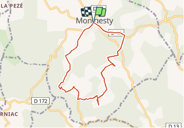
![](/images/other/stat-length.png)
![Tour Wandern Montgesty - Montgesty - Photo](https://media.geolcdn.com/t/1900/400/ext.pjpeg?maxdim=2&url=https%3A%2F%2Fservices.sitytrail.com%2FGeolivesWS%2FDownloadMedia.ashx%3FTrailID%3D101247%26Media%3D735_1.jpg)
Montgesty
tracegps
Benutzer
![Länge](/images/other/stat-length.png)
Länge
7,6 km
![Maximale Höhe](https://static1.geolcdn.com/siteimages/upload/files/1508320355ic_sort_altitude_max_24dp.png)
Maximale Höhe
312 m
![Positive Höhendifferenz](https://static1.geolcdn.com/siteimages/upload/files/1508320355ic_sort_den_pos_24dp.png)
Positive Höhendifferenz
159 m
![Km-Effort](/images/other/stat-length.png)
Km-Effort
9,7 km
![Min. Höhe](https://static1.geolcdn.com/siteimages/upload/files/1508320355ic_sort_altitude_min_24dp.png)
Min. Höhe
184 m
![Negative Höhendifferenz](https://static1.geolcdn.com/siteimages/upload/files/1508320355ic_sort_den_neg_24dp.png)
Negative Höhendifferenz
160 m
![Boucle](https://static1.geolcdn.com/siteimages/upload/files/16400158638029165_repeat_loop_refresh_sync_direction_icon.png)
Boucle
Ja
Erstellungsdatum :
2014-12-10 00:00:00.0
Letzte Änderung :
2014-12-10 00:00:00.0
![Wandern](https://static1.geolcdn.com/sitytour/trail-icons/101.png)
2h30
Schwierigkeit : Medium
![Scannen Sie diesen QR-Code, um die Tour in der SityTrail-Anwendung zu öffnen](https://capi.geolives.com/qq0zvz2zws4bq2lad0pu/sitytour/trails/101247/qr.png?size=200)
Kostenlosegpshiking-Anwendung
Über SityTrail
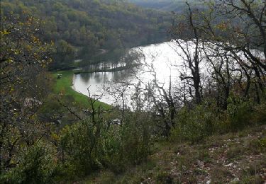
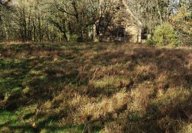
Tour Wandern von 7,6 km verfügbar auf Okzitanien, Lot, Montgesty. Diese Tour wird von tracegps vorgeschlagen.
Beschreibung
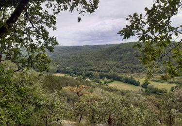
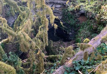
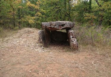
Belle balade pour tous, moulin à vent, menhir, pierres sèches, cabanes...agrémentent cette promenade sans difficultés particulières. D'autres infos pour une belle promenade sur Rando.eu
Ort
Land:
France
Region :
Okzitanien
Abteilung/Provinz :
Lot
Kommune :
Montgesty
Standort:
Unknown
Gehen Sie:(Dec)
Gehen Sie:(UTM)
364721 ; 4937624 (31T) N.
Kommentare
Touren in der Umgebung
![Tour Wandern Les Junies - T1 - Photo](https://media.geolcdn.com/t/375/260/ext.jpg?maxdim=2&url=https%3A%2F%2Fmedia.geolcdn.com%2Ff%2Ffad83b92-954b-44e0-9018-161ac3ae854f.jpg)
![Wandern Wandern](https://static1.geolcdn.com/sitytour/trail-icons/101.png)
![Tour Wandern Montgesty - Montgesty - Photo](https://media.geolcdn.com/t/375/260/ext.jpg?maxdim=2&url=https%3A%2F%2Fmedia.geolcdn.com%2Ff%2Fba0aa058-b6ad-4004-8313-7b5a08a3e041.jpg)
![Wandern Wandern](https://static1.geolcdn.com/sitytour/trail-icons/101.png)
![Tour Wandern Catus - Ballade du gouffre - Photo](https://media.geolcdn.com/t/375/260/ext.jpg?maxdim=2&url=https%3A%2F%2Fmedia.geolcdn.com%2Ff%2F670b093d-0ea6-4015-a373-86bc6b351af7.jpg)
![Wandern Wandern](https://static1.geolcdn.com/sitytour/trail-icons/101.png)
![Tour Wandern Les Junies - les junies - Photo](https://media.geolcdn.com/t/375/260/ext.jpg?maxdim=2&url=https%3A%2F%2Fmedia.geolcdn.com%2Ff%2F76d02f5a-fbe7-4ae2-9039-75af13e1e019.jpg)
![Wandern Wandern](https://static1.geolcdn.com/sitytour/trail-icons/101.png)
![Tour Nordic Walking Catus - Catus,Rostassac,Catus - Photo](https://media.geolcdn.com/t/375/260/ext.jpg?maxdim=2&url=https%3A%2F%2Fservices.sitytrail.com%2FGeolivesWS%2FDownloadMedia.ashx%3FTrailID%3D95927%26Media%3D9aea7b6d-bd96-48be-8ba0-a44ab1349fb2.JPG)
![Nordic Walking Nordic Walking](https://static1.geolcdn.com/sitytour/trail-icons/102.png)
Catus,Rostassac,Catus
Nordic Walking
Medium
Catus,
Okzitanien,
Lot,
France
![](/images/other/stat-length.png)
18,1 km | 24 km-effort
2h 56min
![](https://static1.geolcdn.com/siteimages/upload/files/16400158638029165_repeat_loop_refresh_sync_direction_icon.png)
Ja
![Tour Wandern Catus - Catus-le Gravenas_Vilary_Combe du Loup 4,6 - Photo](https://media.geolcdn.com/t/375/260/ext.jpg?maxdim=2&url=https%3A%2F%2Fmedia.geolcdn.com%2Ff%2F7b8232a9-5c68-4af3-a797-f58d0bf39a9f.jpg)
![Wandern Wandern](https://static1.geolcdn.com/sitytour/trail-icons/101.png)
Catus-le Gravenas_Vilary_Combe du Loup 4,6
Wandern
Sehr leicht
Catus,
Okzitanien,
Lot,
France
![](/images/other/stat-length.png)
4,6 km | 6,3 km-effort
2h 33min
![](https://static1.geolcdn.com/siteimages/upload/files/16400158638029165_repeat_loop_refresh_sync_direction_icon.png)
Ja
![Tour Wandern Catus - Catus Vilary_Mas de Fraysse 5,3 - Photo](https://media.geolcdn.com/t/375/260/ext.jpg?maxdim=2&url=https%3A%2F%2Fmedia.geolcdn.com%2Ff%2Fec2d36cb-15cb-402f-aa28-9dd72c888fbf.jpg)
![Wandern Wandern](https://static1.geolcdn.com/sitytour/trail-icons/101.png)
Catus Vilary_Mas de Fraysse 5,3
Wandern
Sehr leicht
Catus,
Okzitanien,
Lot,
France
![](/images/other/stat-length.png)
5,3 km | 7,2 km-effort
1h 26min
![](https://static1.geolcdn.com/siteimages/upload/files/16400158638029165_repeat_loop_refresh_sync_direction_icon.png)
Ja
![Tour sport Saint-Médard - Raynal - Photo](https://media.geolcdn.com/t/375/260/ext.jpg?maxdim=2&url=https%3A%2F%2Fsecurestorage.geolives.com%2Fsitytour%2Ftrail-bg%2Fdefault.jpg)
![Tour Wandern Catus - Les Marines 7,5 - Photo](https://media.geolcdn.com/t/375/260/ext.jpg?maxdim=2&url=https%3A%2F%2Fmedia.geolcdn.com%2Ff%2F3ff37071-9f85-4d92-be37-a6cc82c921cb.jpg)
![Wandern Wandern](https://static1.geolcdn.com/sitytour/trail-icons/101.png)
Les Marines 7,5
Wandern
Sehr leicht
Catus,
Okzitanien,
Lot,
France
![](/images/other/stat-length.png)
7,5 km | 9,4 km-effort
2h 22min
![](https://static1.geolcdn.com/siteimages/upload/files/16400158638029165_repeat_loop_refresh_sync_direction_icon.png)
Ja