![](/images/other/stat-length.png)
![Tour Mountainbike Orschweiler - Circuit du Premier Mai - Photo](https://media.geolcdn.com/t/1900/400/ext.pjpeg?maxdim=2&url=https%3A%2F%2Fservices.sitytrail.com%2FGeolivesWS%2FDownloadMedia.ashx%3FTrailID%3D101145%26Media%3D633_1.jpg)
Circuit du Premier Mai
tracegps
Benutzer
![Länge](/images/other/stat-length.png)
![Maximale Höhe](https://static1.geolcdn.com/siteimages/upload/files/1508320355ic_sort_altitude_max_24dp.png)
![Positive Höhendifferenz](https://static1.geolcdn.com/siteimages/upload/files/1508320355ic_sort_den_pos_24dp.png)
![Km-Effort](/images/other/stat-length.png)
![Min. Höhe](https://static1.geolcdn.com/siteimages/upload/files/1508320355ic_sort_altitude_min_24dp.png)
![Negative Höhendifferenz](https://static1.geolcdn.com/siteimages/upload/files/1508320355ic_sort_den_neg_24dp.png)
![Boucle](https://static1.geolcdn.com/siteimages/upload/files/16400158638029165_repeat_loop_refresh_sync_direction_icon.png)
![Mountainbike](https://static1.geolcdn.com/sitytour/trail-icons/202.png)
1h00
Schwierigkeit : Schwierig
![Scannen Sie diesen QR-Code, um die Tour in der SityTrail-Anwendung zu öffnen](https://capi.geolives.com/qq0zvz2zws4bq2lad0pu/sitytour/trails/101145/qr.png?size=200)
Kostenlosegpshiking-Anwendung
Über SityTrail
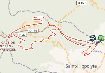
Tour Mountainbike von 13,1 km verfügbar auf Großer Osten, Unterelsass, Orschweiler. Diese Tour wird von tracegps vorgeschlagen.
Beschreibung
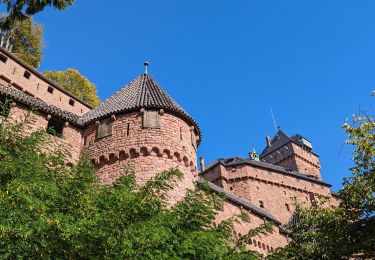
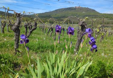
Initialement, ce circuit était prévu pour une rando pédestre. La reconnaissance que j'ai effectué à VTT m'a bien plu... et j'ai décidé de le publier ici. Le circuit n'est pas très long et peut servir d'entraînement ou de défouloir le soir. La première montée se fait sur un chemin large et carrossable. Ensuite, la partie menant au château du Haut-Koenigsbourg est plus étroite, puis, après un croisement, plus technique. La fin est marqué par un virage en épingle à droite et une volée de marche qui vous mèneront sur une plateforme face à l'entrée du château. Longez-le par la gauche et rejoignez le carrefour du Schaentzel par le GR5. Suivez la route vers Thannenkirsch sur environ 40 mètres, puis plongez à gauche. Attention de ne pas manquer l'embranchement vers la Roches des Fées. Ce tronçon est particulièrement ludique jusqu'à la tombe de l'ermite. Passage par le Teufelsloch, puis la fontaine du Chevreuil pour rejoindre le chemin de la première montée (sans vous y engager) par un sentier en balcon très plaisant. Redescendez sur Orschwiller par le sentier sur la crête. Attention toutefois à la fin, un escalier raide vous ramène sur le sentier triangle bleu. Vous pouvez contournez la difficulté en empruntant les lacets dans le vignoble après avoir atteint la porte grillagée. Une deuxième série de marche, plus facile celle-là, vous ramène au point de départ. D'autres infos et croquis sont ICI
Ort
Kommentare
Touren in der Umgebung
![Tour Wandern Kestenholz - Le Hahnenberg et les balcons Sélestat - Photo](https://media.geolcdn.com/t/375/260/ext.jpg?maxdim=2&url=https%3A%2F%2Fservices.sitytrail.com%2FGeolivesWS%2FDownloadMedia.ashx%3FTrailID%3D160509%26Media%3D20121030151326.jpeg)
![Wandern Wandern](https://static1.geolcdn.com/sitytour/trail-icons/101.png)
Wandern
![](/images/other/stat-length.png)
![](https://static1.geolcdn.com/siteimages/upload/files/16400158638029165_repeat_loop_refresh_sync_direction_icon.png)
![Tour Wandern Kestenholz - Le Haut Koenigsbourg de Val de Ville - Photo](https://media.geolcdn.com/t/375/260/ext.jpg?maxdim=2&url=https%3A%2F%2Fservices.sitytrail.com%2FGeolivesWS%2FDownloadMedia.ashx%3FTrailID%3D101918%26Media%3D2205_1.jpg)
![Wandern Wandern](https://static1.geolcdn.com/sitytour/trail-icons/101.png)
Wandern
![](/images/other/stat-length.png)
![](https://static1.geolcdn.com/siteimages/upload/files/16400158638029165_repeat_loop_refresh_sync_direction_icon.png)
![Tour Wandern Kinzheim - suuntoapp-Hiking-2023-10-15T07-53-44Z - Photo](https://media.geolcdn.com/t/375/260/10137816-bbc2-48a8-ba49-81d776e456aa.jpg&format=jpg&maxdim=2)
![Wandern Wandern](https://static1.geolcdn.com/sitytour/trail-icons/101.png)
Wandern
![](/images/other/stat-length.png)
![](https://static1.geolcdn.com/siteimages/upload/files/16400158638029165_repeat_loop_refresh_sync_direction_icon.png)
![Tour Wandern Sankt Pilt - St hippolyte ht koenigsbourg - Photo](https://media.geolcdn.com/t/375/260/ext.jpg?maxdim=2&url=https%3A%2F%2Fstatic1.geolcdn.com%2Fsiteimages%2Fupload%2Ffiles%2F1553511878bg_sport_marche.png)
![Wandern Wandern](https://static1.geolcdn.com/sitytour/trail-icons/101.png)
Wandern
![](/images/other/stat-length.png)
![](https://static1.geolcdn.com/siteimages/upload/files/16400158638029165_repeat_loop_refresh_sync_direction_icon.png)
![Tour Wandern Bergheim - Berghien - Photo](https://media.geolcdn.com/t/375/260/9521df30-806f-464d-a648-d6cec2b043b6.jpg&format=jpg&maxdim=2)
![Wandern Wandern](https://static1.geolcdn.com/sitytour/trail-icons/101.png)
Wandern
![](/images/other/stat-length.png)
![](https://static1.geolcdn.com/siteimages/upload/files/16400158638029165_repeat_loop_refresh_sync_direction_icon.png)
![Tour Wandern Sankt Pilt - St-Hippolyte - Rorschwihr - Grasberg - Bergheim - Reichenberg - Rodern - Photo](https://media.geolcdn.com/t/375/260/44aae6a9-c2ff-44af-afea-23b4ed406441.jpg&format=jpg&maxdim=2)
![Wandern Wandern](https://static1.geolcdn.com/sitytour/trail-icons/101.png)
Wandern
![](/images/other/stat-length.png)
![](https://static1.geolcdn.com/siteimages/upload/files/16400158638029165_repeat_loop_refresh_sync_direction_icon.png)
![Tour Elektrofahrrad Schlettstadt - Vignoble - Photo](https://media.geolcdn.com/t/375/260/d954fb43-4e0e-478c-8563-9315c95797e7.jpg&format=jpg&maxdim=2)
![Elektrofahrrad Elektrofahrrad](https://static1.geolcdn.com/sitytour/trail-icons/205.png)
Elektrofahrrad
![](/images/other/stat-length.png)
![](https://static1.geolcdn.com/siteimages/upload/files/16400158638029165_repeat_loop_refresh_sync_direction_icon.png)
![Tour Wandern Rorschweier - rorschwihr ac3 - Photo](https://media.geolcdn.com/t/375/260/e1a4436c-3b58-4f87-aa1a-a05aec25fee3.jpg&format=jpg&maxdim=2)
![Wandern Wandern](https://static1.geolcdn.com/sitytour/trail-icons/101.png)
Wandern
![](/images/other/stat-length.png)
![](https://static1.geolcdn.com/siteimages/upload/files/16400158638029165_repeat_loop_refresh_sync_direction_icon.png)
![Tour Elektrofahrrad Schlettstadt - Sélestat eckbo - Photo](https://media.geolcdn.com/t/375/260/01c67454-8b4b-4061-b826-b14fbe83434d.jpg&format=jpg&maxdim=2)
![Elektrofahrrad Elektrofahrrad](https://static1.geolcdn.com/sitytour/trail-icons/205.png)
Elektrofahrrad
![](/images/other/stat-length.png)
![](https://static1.geolcdn.com/siteimages/upload/files/16400158638029165_repeat_loop_refresh_sync_direction_icon.png)