![](/images/other/stat-length.png)
![Tour Mountainbike Bellême - La Bell'Rando 2005 - Photo](https://media.geolcdn.com/t/1900/400/ext.pjpeg?maxdim=2&url=https%3A%2F%2Fservices.sitytrail.com%2FGeolivesWS%2FDownloadMedia.ashx%3FTrailID%3D101083%26Media%3D573_2.jpg)
La Bell'Rando 2005
tracegps
Benutzer
![Länge](/images/other/stat-length.png)
![Maximale Höhe](https://static1.geolcdn.com/siteimages/upload/files/1508320355ic_sort_altitude_max_24dp.png)
![Positive Höhendifferenz](https://static1.geolcdn.com/siteimages/upload/files/1508320355ic_sort_den_pos_24dp.png)
![Km-Effort](/images/other/stat-length.png)
![Min. Höhe](https://static1.geolcdn.com/siteimages/upload/files/1508320355ic_sort_altitude_min_24dp.png)
![Negative Höhendifferenz](https://static1.geolcdn.com/siteimages/upload/files/1508320355ic_sort_den_neg_24dp.png)
![Boucle](https://static1.geolcdn.com/siteimages/upload/files/16400158638029165_repeat_loop_refresh_sync_direction_icon.png)
![Mountainbike](https://static1.geolcdn.com/sitytour/trail-icons/202.png)
3h15
Schwierigkeit : Sehr schwierig
![Scannen Sie diesen QR-Code, um die Tour in der SityTrail-Anwendung zu öffnen](https://capi.geolives.com/qq0zvz2zws4bq2lad0pu/sitytour/trails/101083/qr.png?size=200)
Kostenlosegpshiking-Anwendung
Über SityTrail
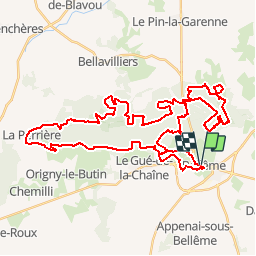
Tour Mountainbike von 50 km verfügbar auf Normandie, Orne, Bellême. Diese Tour wird von tracegps vorgeschlagen.
Beschreibung
28 Aout 2005 Un peu de bitume puis rapidement on rentre en sous bois. Dommage que ce soit un départ groupé car on sera rapidement sur des sentiers étroits rendant difficile le dépassement, mais comme le parcours n'est pas technique où ne présente pas de bosse raide au départ, il n'y aura pas de bouchon. Il faudra au moins 10km avant d'être tranquille sur les chemins. Une petite excursion campagnarde vers La Perrière, jolis sentiers et chemins de bocage, puis on retourne dans la forêt de Bellême.... La suite est ICI
Ort
Kommentare
Touren in der Umgebung
![Tour Wandern Belforêt-en-Perche - Chêne séculaire - Bellême - Photo](https://media.geolcdn.com/t/375/260/ext.jpg?maxdim=2&url=https%3A%2F%2Fservices.sitytrail.com%2FGeolivesWS%2FDownloadMedia.ashx%3FTrailID%3D111658%26Media%3D7896_2.jpg)
![Wandern Wandern](https://static1.geolcdn.com/sitytour/trail-icons/101.png)
Wandern
![](/images/other/stat-length.png)
![](https://static1.geolcdn.com/siteimages/upload/files/16400158638029165_repeat_loop_refresh_sync_direction_icon.png)
![Tour Wandern Bellême - de belleme a l'etang de la herse - Photo](https://media.geolcdn.com/t/375/260/cf5fb921-4c5a-49a3-9ce7-3714cc541daf.jpg&format=jpg&maxdim=2)
![Wandern Wandern](https://static1.geolcdn.com/sitytour/trail-icons/101.png)
Wandern
![](/images/other/stat-length.png)
![](https://static1.geolcdn.com/siteimages/upload/files/16400158638029165_repeat_loop_refresh_sync_direction_icon.png)
![Tour Zu Fuß Saint-Martin-du-Vieux-Bellême - Chêne séculaire - Photo](https://media.geolcdn.com/t/375/260/1e7dc81d-cfa6-49bd-86cc-f4a86c5edf07.jpeg&format=jpg&maxdim=2)
![Zu Fuß Zu Fuß](https://static1.geolcdn.com/sitytour/trail-icons/100.png)
Zu Fuß
![](/images/other/stat-length.png)
![](https://static1.geolcdn.com/siteimages/upload/files/16400158638029165_repeat_loop_refresh_sync_direction_icon.png)
![Tour Elektrofahrrad Bellême - circuit des vallées bellemoises - Photo](https://media.geolcdn.com/t/375/260/8942d37a-44b6-4034-87b6-86b0b9a49d8c.jpg&format=jpg&maxdim=2)
![Elektrofahrrad Elektrofahrrad](https://static1.geolcdn.com/sitytour/trail-icons/205.png)
Elektrofahrrad
![](/images/other/stat-length.png)
![](https://static1.geolcdn.com/siteimages/upload/files/16400158638029165_repeat_loop_refresh_sync_direction_icon.png)
![Tour Wandern Bellême - Bellême - Mortagne-au-Perche 23 km - Photo](https://media.geolcdn.com/t/375/260/648b0c04-c9f6-4954-a7eb-873b2f717454.jpg&format=jpg&maxdim=2)
![Wandern Wandern](https://static1.geolcdn.com/sitytour/trail-icons/101.png)
Wandern
![](/images/other/stat-length.png)
![](https://static1.geolcdn.com/siteimages/upload/files/16400158638029165_repeat_loop_refresh_sync_direction_icon.png)
![Tour Wandern Bellême - Bellême - Nocé/Courboyer 17 km - Photo](https://media.geolcdn.com/t/375/260/0a669ee2-665f-435c-8b9c-5b0346d2e0a4.jpg&format=jpg&maxdim=2)
![Wandern Wandern](https://static1.geolcdn.com/sitytour/trail-icons/101.png)
Wandern
![](/images/other/stat-length.png)
![](https://static1.geolcdn.com/siteimages/upload/files/16400158638029165_repeat_loop_refresh_sync_direction_icon.png)
![Tour Wandern Bellême - Traversées Percheronnes Bellême - Gémages 15,4 Km - Photo](https://media.geolcdn.com/t/375/260/23f7282d-ffa3-4b2e-a94a-5dc4af001232.jpg&format=jpg&maxdim=2)
![Wandern Wandern](https://static1.geolcdn.com/sitytour/trail-icons/101.png)
Wandern
![](/images/other/stat-length.png)
![](https://static1.geolcdn.com/siteimages/upload/files/16400158638029165_repeat_loop_refresh_sync_direction_icon.png)
![Tour Wandern Bellême - Bellême - La Perrière 12 km - Photo](https://media.geolcdn.com/t/375/260/b423f935-0a19-479d-aaad-bc5a9bf55dc8.jpg&format=jpg&maxdim=2)
![Wandern Wandern](https://static1.geolcdn.com/sitytour/trail-icons/101.png)
Wandern
![](/images/other/stat-length.png)
![](https://static1.geolcdn.com/siteimages/upload/files/16400158638029165_repeat_loop_refresh_sync_direction_icon.png)
![Tour Wandern Bellême - Bellême - Mauves-sur-Huisne 14 km - Photo](https://media.geolcdn.com/t/375/260/bd52a7c3-ac84-428f-b134-e425824892a0.jpg&format=jpg&maxdim=2)
![Wandern Wandern](https://static1.geolcdn.com/sitytour/trail-icons/101.png)
Wandern
![](/images/other/stat-length.png)
![](https://static1.geolcdn.com/siteimages/upload/files/16400158638029165_repeat_loop_refresh_sync_direction_icon.png)