![](/images/other/stat-length.png)
![Tour Laufen Diedolshausen - Les Bagenelles - Photo](https://media.geolcdn.com/t/1900/400/ext.pjpeg?maxdim=2&url=https%3A%2F%2Fservices.sitytrail.com%2FGeolivesWS%2FDownloadMedia.ashx%3FTrailID%3D101072%26Media%3D559_1.jpg)
Les Bagenelles
tracegps
Benutzer
![Länge](/images/other/stat-length.png)
![Maximale Höhe](https://static1.geolcdn.com/siteimages/upload/files/1508320355ic_sort_altitude_max_24dp.png)
![Positive Höhendifferenz](https://static1.geolcdn.com/siteimages/upload/files/1508320355ic_sort_den_pos_24dp.png)
![Km-Effort](/images/other/stat-length.png)
![Min. Höhe](https://static1.geolcdn.com/siteimages/upload/files/1508320355ic_sort_altitude_min_24dp.png)
![Negative Höhendifferenz](https://static1.geolcdn.com/siteimages/upload/files/1508320355ic_sort_den_neg_24dp.png)
![Boucle](https://static1.geolcdn.com/siteimages/upload/files/16400158638029165_repeat_loop_refresh_sync_direction_icon.png)
![Laufen](https://static1.geolcdn.com/sitytour/trail-icons/103.png)
2h00
Schwierigkeit : Schwierig
![Scannen Sie diesen QR-Code, um die Tour in der SityTrail-Anwendung zu öffnen](https://capi.geolives.com/qq0zvz2zws4bq2lad0pu/sitytour/trails/101072/qr.png?size=200)
Kostenlosegpshiking-Anwendung
Über SityTrail
Tour Laufen von 13 km verfügbar auf Großer Osten, Oberelsass, Diedolshausen. Diese Tour wird von tracegps vorgeschlagen.
Beschreibung
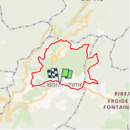
Le départ de ce circuit se situe à l'intersection de la N415 et de la D48. Les premières balises sont un peu délavés par le soleil. Le circuit démarre par une longue montée sur macadam jusqu'à un carrefour marqué par une croix. On rejoint alors le circuit W1. Petites montées et descentes jusqu'au col des Bagenelles. De là une montée raide étagée en 3 parties, puis une longue descente la plupart du temps sur macadam aussi. Pas de difficultés techniques à signaler. D'autres infos ICI
Ort
Kommentare
Touren in der Umgebung
![Tour Wandern Diedolshausen - Tête des faux . - Photo](https://media.geolcdn.com/t/375/260/84fec98d-7f8b-4bf8-a434-52c0363ad440.jpg&format=jpg&maxdim=2)
![Wandern Wandern](https://static1.geolcdn.com/sitytour/trail-icons/101.png)
Wandern
![](/images/other/stat-length.png)
![](https://static1.geolcdn.com/siteimages/upload/files/16400158638029165_repeat_loop_refresh_sync_direction_icon.png)
![Tour Wandern Schnierlach - 2012-06-16 Marche aux Alisiers Orbey - Photo](https://media.geolcdn.com/t/375/260/ext.jpg?maxdim=2&url=https%3A%2F%2Fstatic1.geolcdn.com%2Fsiteimages%2Fupload%2Ffiles%2F1553511878bg_sport_marche.png)
![Wandern Wandern](https://static1.geolcdn.com/sitytour/trail-icons/101.png)
Wandern
![](/images/other/stat-length.png)
![](https://static1.geolcdn.com/siteimages/upload/files/16400158638029165_repeat_loop_refresh_sync_direction_icon.png)
![Tour Mountainbike Urbeis - Lac Blanc - Têtes des Faux - Photo](https://media.geolcdn.com/t/375/260/ext.jpg?maxdim=2&url=https%3A%2F%2Fservices.sitytrail.com%2FGeolivesWS%2FDownloadMedia.ashx%3FTrailID%3D101197%26Media%3D684_1.jpg)
![Mountainbike Mountainbike](https://static1.geolcdn.com/sitytour/trail-icons/202.png)
Mountainbike
![](/images/other/stat-length.png)
![](https://static1.geolcdn.com/siteimages/upload/files/16400158638029165_repeat_loop_refresh_sync_direction_icon.png)
![Tour Wandern Diedolshausen - Le Bonhomme - Circuit du village - Photo](https://media.geolcdn.com/t/375/260/ext.jpg?maxdim=2&url=https%3A%2F%2Fstatic1.geolcdn.com%2Fsiteimages%2Fupload%2Ffiles%2F1553511878bg_sport_marche.png)
![Wandern Wandern](https://static1.geolcdn.com/sitytour/trail-icons/101.png)
Wandern
![](/images/other/stat-length.png)
![](https://static1.geolcdn.com/siteimages/upload/files/16400158638029165_repeat_loop_refresh_sync_direction_icon.png)
![Tour Wandern Markirch - 2021-02-14 Marche Bagenelles Brezouard Fuste de Etoile - Photo](https://media.geolcdn.com/t/375/260/79d211e6-ae5a-4d3f-8163-d2103469db38.jpg&format=jpg&maxdim=2)
![Wandern Wandern](https://static1.geolcdn.com/sitytour/trail-icons/101.png)
Wandern
![](/images/other/stat-length.png)
![](https://static1.geolcdn.com/siteimages/upload/files/16400158638029165_repeat_loop_refresh_sync_direction_icon.png)
![Tour Wandern Schnierlach - 2020-07-19 Marche Étang du Devin Col Calvaire Tête des Faux - Photo](https://media.geolcdn.com/t/375/260/615f03a1-e6aa-4706-9550-1df8400dcef8.jpg&format=jpg&maxdim=2)
![Wandern Wandern](https://static1.geolcdn.com/sitytour/trail-icons/101.png)
Wandern
![](/images/other/stat-length.png)
![](https://static1.geolcdn.com/siteimages/upload/files/16400158638029165_repeat_loop_refresh_sync_direction_icon.png)
![Tour Wandern Urbeis - Vallée des 5 lacs - Photo](https://media.geolcdn.com/t/375/260/96031f65-b958-4b6d-af19-7cecb860729d.jpg&format=jpg&maxdim=2)
![Wandern Wandern](https://static1.geolcdn.com/sitytour/trail-icons/101.png)
Wandern
![](/images/other/stat-length.png)
![](https://static1.geolcdn.com/siteimages/upload/files/16400158638029165_repeat_loop_refresh_sync_direction_icon.png)
![Tour Mountainbike Urbeis - Welche E Bike Tour 2024 - Photo](https://media.geolcdn.com/t/375/260/8d9a6867-e2f3-410d-af18-d6097d6fcf56.jpg&format=jpg&maxdim=2)
![Mountainbike Mountainbike](https://static1.geolcdn.com/sitytour/trail-icons/202.png)
Mountainbike
![](/images/other/stat-length.png)
![](https://static1.geolcdn.com/siteimages/upload/files/16400158638029165_repeat_loop_refresh_sync_direction_icon.png)
![Tour Wandern Urbeis - Col du Calvaire ➡️ Lac Blanc - Photo](https://media.geolcdn.com/t/375/260/d45f3e65-0b13-4169-803a-9a82fdb05a2b.jpg&format=jpg&maxdim=2)
![Wandern Wandern](https://static1.geolcdn.com/sitytour/trail-icons/101.png)
Wandern
![](/images/other/stat-length.png)
![](https://static1.geolcdn.com/siteimages/upload/files/16400158638029165_repeat_loop_refresh_sync_direction_icon.png)