![](/images/other/stat-length.png)
![Tour Wandern Villanders - Villanderer Alm - Photo](https://media.geolcdn.com/t/1900/400/ext.pjpeg?maxdim=2&url=https%3A%2F%2Fservices.sitytrail.com%2FGeolivesWS%2FDownloadMedia.ashx%3FTrailID%3D1010396%26Media%3Dfix__20180722143429.jpg)
Villanderer Alm
VacheKiri67
Benutzer
![Länge](/images/other/stat-length.png)
Länge
13,7 km
![Maximale Höhe](https://static1.geolcdn.com/siteimages/upload/files/1508320355ic_sort_altitude_max_24dp.png)
Maximale Höhe
2369 m
![Positive Höhendifferenz](https://static1.geolcdn.com/siteimages/upload/files/1508320355ic_sort_den_pos_24dp.png)
Positive Höhendifferenz
645 m
![Km-Effort](/images/other/stat-length.png)
Km-Effort
22 km
![Min. Höhe](https://static1.geolcdn.com/siteimages/upload/files/1508320355ic_sort_altitude_min_24dp.png)
Min. Höhe
1726 m
![Negative Höhendifferenz](https://static1.geolcdn.com/siteimages/upload/files/1508320355ic_sort_den_neg_24dp.png)
Negative Höhendifferenz
656 m
![Boucle](https://static1.geolcdn.com/siteimages/upload/files/16400158638029165_repeat_loop_refresh_sync_direction_icon.png)
Boucle
Ja
Erstellungsdatum :
2018-07-27 13:28:58.628
Letzte Änderung :
2018-07-27 13:28:58.884
![Wandern](https://static1.geolcdn.com/sitytour/trail-icons/101.png)
4h44
Schwierigkeit : Medium
![Scannen Sie diesen QR-Code, um die Tour in der SityTrail-Anwendung zu öffnen](https://capi.geolives.com/qq0zvz2zws4bq2lad0pu/sitytour/trails/1010396/qr.png?size=200)
Kostenlosegpshiking-Anwendung
Über SityTrail
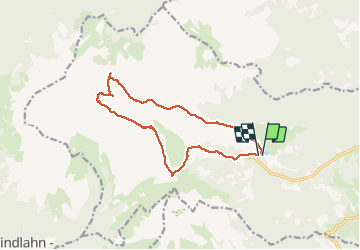
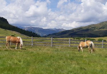
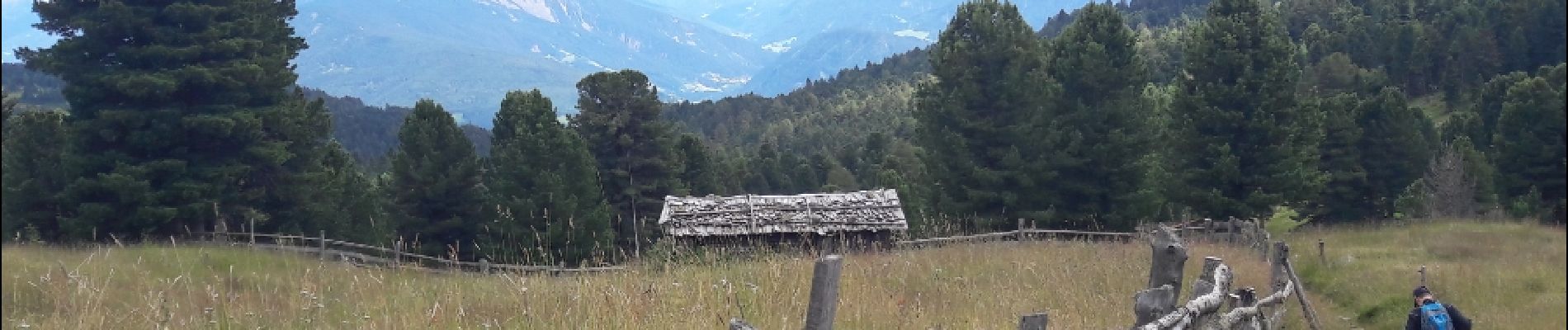
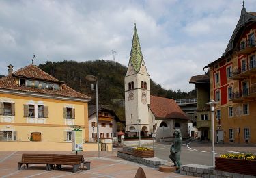
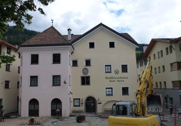
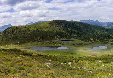
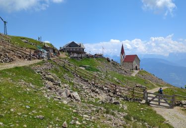
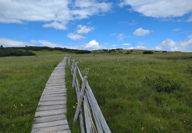
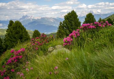
Tour Wandern von 13,7 km verfügbar auf Trentino-Südtirol, Bozen, Villanders. Diese Tour wird von VacheKiri67 vorgeschlagen.
Beschreibung
Faite le 22/07/2018 avec notre fils Théo de 13 ans. D'après "Wanderung zum Totensee" du site www.sentres.com. Durée indiquée pour le circuit : 4h.
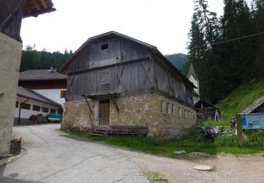
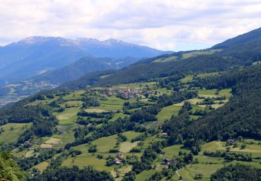
Ort
Land:
Italy
Region :
Trentino-Südtirol
Abteilung/Provinz :
Bozen
Kommune :
Villanders
Standort:
Unknown
Gehen Sie:(Dec)
Gehen Sie:(UTM)
690575 ; 5168331 (32T) N.
Kommentare
Touren in der Umgebung
![Tour Zu Fuß Waidbruck - IT-2 - Photo](https://media.geolcdn.com/t/375/260/e0ac3740-6bb0-4363-b8ea-fef33f89412d.jpeg&format=jpg&maxdim=2)
![Zu Fuß Zu Fuß](https://static1.geolcdn.com/sitytour/trail-icons/100.png)
IT-2
Zu Fuß
Einfach
Waidbruck,
Trentino-Südtirol,
Bozen,
Italy
![](/images/other/stat-length.png)
6,5 km | 14,5 km-effort
3h 17min
![](https://static1.geolcdn.com/siteimages/upload/files/16400158638029165_repeat_loop_refresh_sync_direction_icon.png)
Nein
![Tour Zu Fuß Villanders - AVS 3 - Sarnthein - Gasteiger Sattel - Photo](https://media.geolcdn.com/t/375/260/7a56c884-2148-49a5-a8e6-1071292762e5.jpeg&format=jpg&maxdim=2)
![Zu Fuß Zu Fuß](https://static1.geolcdn.com/sitytour/trail-icons/100.png)
AVS 3 - Sarnthein - Gasteiger Sattel
Zu Fuß
Einfach
Villanders,
Trentino-Südtirol,
Bozen,
Italy
![](/images/other/stat-length.png)
10,9 km | 19,4 km-effort
4h 24min
![](https://static1.geolcdn.com/siteimages/upload/files/16400158638029165_repeat_loop_refresh_sync_direction_icon.png)
Nein
![Tour Zu Fuß Villanders - AVS 6 - Gasserhütte - Schloss Reinegg - Photo](https://media.geolcdn.com/t/375/260/8ccd039a-c2e5-4264-855a-76467199b255.jpeg&format=jpg&maxdim=2)
![Zu Fuß Zu Fuß](https://static1.geolcdn.com/sitytour/trail-icons/100.png)
AVS 6 - Gasserhütte - Schloss Reinegg
Zu Fuß
Einfach
Villanders,
Trentino-Südtirol,
Bozen,
Italy
![](/images/other/stat-length.png)
8,8 km | 14,9 km-effort
3h 23min
![](https://static1.geolcdn.com/siteimages/upload/files/16400158638029165_repeat_loop_refresh_sync_direction_icon.png)
Nein
![Tour Wandern Klausen - Latzfonser Kreuz - Photo](https://media.geolcdn.com/t/375/260/5199fe23-d97f-4485-b60c-4137de516108.jpg&format=jpg&maxdim=2)
![Wandern Wandern](https://static1.geolcdn.com/sitytour/trail-icons/101.png)
Latzfonser Kreuz
Wandern
Schwierig
Klausen,
Trentino-Südtirol,
Bozen,
Italy
![](/images/other/stat-length.png)
14,8 km | 27 km-effort
6h 24min
![](https://static1.geolcdn.com/siteimages/upload/files/16400158638029165_repeat_loop_refresh_sync_direction_icon.png)
Ja
![Tour Wandern Villanders - Villanderer Alm - Stöfflhütte et prairies marécageuses - Photo](https://media.geolcdn.com/t/375/260/f4cfb224-6033-401b-93cf-b575e7aa3743.jpg&format=jpg&maxdim=2)
![Wandern Wandern](https://static1.geolcdn.com/sitytour/trail-icons/101.png)
Villanderer Alm - Stöfflhütte et prairies marécageuses
Wandern
Medium
Villanders,
Trentino-Südtirol,
Bozen,
Italy
![](/images/other/stat-length.png)
15,7 km | 22 km-effort
5h 3min
![](https://static1.geolcdn.com/siteimages/upload/files/16400158638029165_repeat_loop_refresh_sync_direction_icon.png)
Ja
![Tour Zu Fuß Lajen - Vogelweider Rundweg - Photo](https://media.geolcdn.com/t/375/260/9a455e4c-3cb1-4cc0-a415-c3b3bd86d0da.jpeg&format=jpg&maxdim=2)
![Zu Fuß Zu Fuß](https://static1.geolcdn.com/sitytour/trail-icons/100.png)
Vogelweider Rundweg
Zu Fuß
Einfach
Lajen,
Trentino-Südtirol,
Bozen,
Italy
![](/images/other/stat-length.png)
7,2 km | 12,6 km-effort
2h 52min
![](https://static1.geolcdn.com/siteimages/upload/files/16400158638029165_repeat_loop_refresh_sync_direction_icon.png)
Ja
![Tour Zu Fuß Waidbruck - IT-35 - Photo](https://media.geolcdn.com/t/375/260/12765515-e0c9-459e-a3be-aa9cedf5cb11.jpeg&format=jpg&maxdim=2)
![Zu Fuß Zu Fuß](https://static1.geolcdn.com/sitytour/trail-icons/100.png)
IT-35
Zu Fuß
Sehr schwierig
Waidbruck,
Trentino-Südtirol,
Bozen,
Italy
![](/images/other/stat-length.png)
39 km | 70 km-effort
15h 55min
![](https://static1.geolcdn.com/siteimages/upload/files/16400158638029165_repeat_loop_refresh_sync_direction_icon.png)
Nein
![Tour Zu Fuß Klausen - Keschtnweg - Photo](https://media.geolcdn.com/t/375/260/f8e7e421-75f2-4603-b874-cd785ca7ef09.jpeg&format=jpg&maxdim=2)
![Zu Fuß Zu Fuß](https://static1.geolcdn.com/sitytour/trail-icons/100.png)
Keschtnweg
Zu Fuß
Sehr schwierig
Klausen,
Trentino-Südtirol,
Bozen,
Italy
![](/images/other/stat-length.png)
27 km | 41 km-effort
9h 21min
![](https://static1.geolcdn.com/siteimages/upload/files/16400158638029165_repeat_loop_refresh_sync_direction_icon.png)
Nein
![Tour Wandern Villanders - villander - Photo](https://media.geolcdn.com/t/375/260/5d906dbc-1938-4164-ba7e-67500184f50a.jpg&format=jpg&maxdim=2)
![Wandern Wandern](https://static1.geolcdn.com/sitytour/trail-icons/101.png)