![](/images/other/stat-length.png)
![Tour Mountainbike Dieppe - Bonauxilienne 2005 - Photo](https://media.geolcdn.com/t/1900/400/ext.pjpeg?maxdim=2&url=https%3A%2F%2Fservices.sitytrail.com%2FGeolivesWS%2FDownloadMedia.ashx%3FTrailID%3D100970%26Media%3D469_1.jpg)
Bonauxilienne 2005
tracegps
Benutzer
![Länge](/images/other/stat-length.png)
Länge
309 km
![Maximale Höhe](https://static1.geolcdn.com/siteimages/upload/files/1508320355ic_sort_altitude_max_24dp.png)
Maximale Höhe
230 m
![Positive Höhendifferenz](https://static1.geolcdn.com/siteimages/upload/files/1508320355ic_sort_den_pos_24dp.png)
Positive Höhendifferenz
5104 m
![Km-Effort](/images/other/stat-length.png)
Km-Effort
377 km
![Min. Höhe](https://static1.geolcdn.com/siteimages/upload/files/1508320355ic_sort_altitude_min_24dp.png)
Min. Höhe
0 m
![Negative Höhendifferenz](https://static1.geolcdn.com/siteimages/upload/files/1508320355ic_sort_den_neg_24dp.png)
Negative Höhendifferenz
5014 m
![Boucle](https://static1.geolcdn.com/siteimages/upload/files/16400158638029165_repeat_loop_refresh_sync_direction_icon.png)
Boucle
Nein
Erstellungsdatum :
2014-12-10 00:00:00.0
Letzte Änderung :
2014-12-10 00:00:00.0
![Mountainbike](https://static1.geolcdn.com/sitytour/trail-icons/202.png)
9h00
Schwierigkeit : Sehr schwierig
![Scannen Sie diesen QR-Code, um die Tour in der SityTrail-Anwendung zu öffnen](https://capi.geolives.com/qq0zvz2zws4bq2lad0pu/sitytour/trails/100970/qr.png?size=200)
Kostenlosegpshiking-Anwendung
Über SityTrail
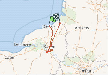
Tour Mountainbike von 309 km verfügbar auf Normandie, Seine-Maritime, Dieppe. Diese Tour wird von tracegps vorgeschlagen.
Beschreibung
Organisée par le club ROUEN EST V2T, l'édition 2005 de la bonaux s'est déroulée le 19/06. Parcours partant du bord de mer (Dieppe) et ralliant la commune de BONSECOURS près de ROUEN (76). On les trouve ICI
Ort
Land:
France
Region :
Normandie
Abteilung/Provinz :
Seine-Maritime
Kommune :
Dieppe
Standort:
Unknown
Gehen Sie:(Dec)
Gehen Sie:(UTM)
362821 ; 5532805 (31U) N.
Kommentare
Touren in der Umgebung
![Tour Wandern Varengeville-sur-Mer - Pourville jusqu'aux Terrasses de Vasterival - Photo](https://media.geolcdn.com/t/375/260/ext.jpg?maxdim=2&url=https%3A%2F%2Fstatic1.geolcdn.com%2Fsiteimages%2Fupload%2Ffiles%2F1553511878bg_sport_marche.png)
![Wandern Wandern](https://static1.geolcdn.com/sitytour/trail-icons/101.png)
Pourville jusqu'aux Terrasses de Vasterival
Wandern
Einfach
(1)
Varengeville-sur-Mer,
Normandie,
Seine-Maritime,
France
![](/images/other/stat-length.png)
11,7 km | 15,1 km-effort
3h 53min
![](https://static1.geolcdn.com/siteimages/upload/files/16400158638029165_repeat_loop_refresh_sync_direction_icon.png)
Ja
![Tour Wandern Dieppe - GR21 : De Dieppe à Pourville-Sur-Mer - Photo](https://media.geolcdn.com/t/375/260/9af66fc9-7eaf-4a54-b63d-df14d7092c30.jpeg&format=jpg&maxdim=2)
![Wandern Wandern](https://static1.geolcdn.com/sitytour/trail-icons/101.png)
GR21 : De Dieppe à Pourville-Sur-Mer
Wandern
Einfach
Dieppe,
Normandie,
Seine-Maritime,
France
![](/images/other/stat-length.png)
8,1 km | 10,9 km-effort
2h 27min
![](https://static1.geolcdn.com/siteimages/upload/files/16400158638029165_repeat_loop_refresh_sync_direction_icon.png)
Nein
![Tour Zu Fuß Dieppe - Dieppe coté mer 1 - Photo](https://media.geolcdn.com/t/375/260/17716324-48c0-4442-af65-fedeb6808833.jpeg&format=jpg&maxdim=2)
![Zu Fuß Zu Fuß](https://static1.geolcdn.com/sitytour/trail-icons/100.png)
Dieppe coté mer 1
Zu Fuß
Sehr leicht
Dieppe,
Normandie,
Seine-Maritime,
France
![](/images/other/stat-length.png)
3,6 km | 4,1 km-effort
56min
![](https://static1.geolcdn.com/siteimages/upload/files/16400158638029165_repeat_loop_refresh_sync_direction_icon.png)
Ja
![Tour Wandern Hautot-sur-Mer - Autour de Varengeville-sur-Mer - Photo](https://media.geolcdn.com/t/375/260/60d902af-7cf1-469a-9cec-da74be4158a3.jpeg&format=jpg&maxdim=2)
![Wandern Wandern](https://static1.geolcdn.com/sitytour/trail-icons/101.png)
Autour de Varengeville-sur-Mer
Wandern
Medium
Hautot-sur-Mer,
Normandie,
Seine-Maritime,
France
![](/images/other/stat-length.png)
20 km | 26 km-effort
4h 19min
![](https://static1.geolcdn.com/siteimages/upload/files/16400158638029165_repeat_loop_refresh_sync_direction_icon.png)
Ja
![Tour Wandern Hautot-sur-Mer - Petit Appeville vers Pourville sur mer - Photo](https://media.geolcdn.com/t/375/260/f27eecc9-b419-4f96-979b-ca5c51e90ae0.jpg&format=jpg&maxdim=2)
![Wandern Wandern](https://static1.geolcdn.com/sitytour/trail-icons/101.png)
Petit Appeville vers Pourville sur mer
Wandern
Medium
Hautot-sur-Mer,
Normandie,
Seine-Maritime,
France
![](/images/other/stat-length.png)
11,5 km | 14,9 km-effort
3h 12min
![](https://static1.geolcdn.com/siteimages/upload/files/16400158638029165_repeat_loop_refresh_sync_direction_icon.png)
Ja
![Tour Wandern Petit-Caux - bracquemont belleville - Photo](https://media.geolcdn.com/t/375/260/da3850e3-aaac-4075-9ca6-53fbc3d5c050.jpg&format=jpg&maxdim=2)
![Wandern Wandern](https://static1.geolcdn.com/sitytour/trail-icons/101.png)
bracquemont belleville
Wandern
Sehr leicht
Petit-Caux,
Normandie,
Seine-Maritime,
France
![](/images/other/stat-length.png)
7,3 km | 8,7 km-effort
1h 54min
![](https://static1.geolcdn.com/siteimages/upload/files/16400158638029165_repeat_loop_refresh_sync_direction_icon.png)
Ja
![Elektrofahrrad Elektrofahrrad](https://static1.geolcdn.com/sitytour/trail-icons/205.png)
Dieppe, sur la trace des impressionnistes
Elektrofahrrad
Medium
Dieppe,
Normandie,
Seine-Maritime,
France
![](/images/other/stat-length.png)
48 km | 54 km-effort
4h 0min
![](https://static1.geolcdn.com/siteimages/upload/files/16400158638029165_repeat_loop_refresh_sync_direction_icon.png)
Ja
![Tour Wandern Dieppe - Dieppe - Photo](https://media.geolcdn.com/t/375/260/25ca68d2-67d2-41cc-84f5-ed5d3a2e8f7b.jpg&format=jpg&maxdim=2)
![Wandern Wandern](https://static1.geolcdn.com/sitytour/trail-icons/101.png)
![Tour Wandern Hautot-sur-Mer - Activity - Photo](https://media.geolcdn.com/t/375/260/58a18e9e-d5e0-45f3-a421-9d8e594845b6.jpg&format=jpg&maxdim=2)
![Wandern Wandern](https://static1.geolcdn.com/sitytour/trail-icons/101.png)
Activity
Wandern
Sehr schwierig
Hautot-sur-Mer,
Normandie,
Seine-Maritime,
France
![](/images/other/stat-length.png)
75 km | 84 km-effort
20h 0min
![](https://static1.geolcdn.com/siteimages/upload/files/16400158638029165_repeat_loop_refresh_sync_direction_icon.png)
Nein