![](/images/other/stat-length.png)
![Tour Wandern Nassogne - NASSOGNE (St-Monon) - Photo](https://media.geolcdn.com/t/1900/400/ext.pjpeg?maxdim=2&url=https%3A%2F%2Fservices.sitytrail.com%2FGeolivesWS%2FDownloadMedia.ashx%3FTrailID%3D1007984%26Media%3Dfix__20180721115335.jpg)
NASSOGNE (St-Monon)
GerardBouche
Benutzer
![Länge](/images/other/stat-length.png)
Länge
9,5 km
![Maximale Höhe](https://static1.geolcdn.com/siteimages/upload/files/1508320355ic_sort_altitude_max_24dp.png)
Maximale Höhe
410 m
![Positive Höhendifferenz](https://static1.geolcdn.com/siteimages/upload/files/1508320355ic_sort_den_pos_24dp.png)
Positive Höhendifferenz
279 m
![Km-Effort](/images/other/stat-length.png)
Km-Effort
13,2 km
![Min. Höhe](https://static1.geolcdn.com/siteimages/upload/files/1508320355ic_sort_altitude_min_24dp.png)
Min. Höhe
233 m
![Negative Höhendifferenz](https://static1.geolcdn.com/siteimages/upload/files/1508320355ic_sort_den_neg_24dp.png)
Negative Höhendifferenz
282 m
![Boucle](https://static1.geolcdn.com/siteimages/upload/files/16400158638029165_repeat_loop_refresh_sync_direction_icon.png)
Boucle
Ja
Erstellungsdatum :
2018-08-19 07:27:05.78
Letzte Änderung :
2018-08-19 07:27:05.78
![Wandern](https://static1.geolcdn.com/sitytour/trail-icons/101.png)
2h47
Schwierigkeit : Einfach
![Scannen Sie diesen QR-Code, um die Tour in der SityTrail-Anwendung zu öffnen](https://capi.geolives.com/qq0zvz2zws4bq2lad0pu/sitytour/trails/1007984/qr.png?size=200)
Kostenlosegpshiking-Anwendung
Über SityTrail
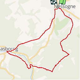
Tour Wandern von 9,5 km verfügbar auf Wallonien, Luxemburg, Nassogne. Diese Tour wird von GerardBouche vorgeschlagen.
Beschreibung
Très belle balade forestière au départ de la maison communale vers le village de Masbourg ... le retour par la rive gauche de la Masblette, un passage à gué et le Tier des Gattes.
Ort
Land:
Belgium
Region :
Wallonien
Abteilung/Provinz :
Luxemburg
Kommune :
Nassogne
Standort:
Nassogne
Gehen Sie:(Dec)
Gehen Sie:(UTM)
667373 ; 5555551 (31U) N.
Kommentare
Touren in der Umgebung
![Tour Wandern Tellin - GG-Lu-13_Grupont - Poix-Saint-Hubert - Photo](https://media.geolcdn.com/t/375/260/5959367f-35e5-42da-bbcc-7bf6a947c3d1.jpg&format=jpg&maxdim=2)
![Wandern Wandern](https://static1.geolcdn.com/sitytour/trail-icons/101.png)
GG-Lu-13_Grupont - Poix-Saint-Hubert
Wandern
Sehr schwierig
(3)
Tellin,
Wallonien,
Luxemburg,
Belgium
![](/images/other/stat-length.png)
26 km | 34 km-effort
7h 23min
![](https://static1.geolcdn.com/siteimages/upload/files/16400158638029165_repeat_loop_refresh_sync_direction_icon.png)
Nein
![Tour Wandern Tellin - Balade à Grupont - Photo](https://media.geolcdn.com/t/375/260/ext.jpg?maxdim=2&url=https%3A%2F%2Fservices.sitytrail.com%2FGeolivesWS%2FDownloadMedia.ashx%3FTrailID%3D963883%26Media%3D35fabe2c-0877-4435-b4f9-1ab0863175f9.jpg)
![Wandern Wandern](https://static1.geolcdn.com/sitytour/trail-icons/101.png)
Balade à Grupont
Wandern
Einfach
(1)
Tellin,
Wallonien,
Luxemburg,
Belgium
![](/images/other/stat-length.png)
8,4 km | 11,9 km-effort
2h 33min
![](https://static1.geolcdn.com/siteimages/upload/files/16400158638029165_repeat_loop_refresh_sync_direction_icon.png)
Ja
![Tour Wandern Tellin - Grupont - Promenade du Bois du Machi (EN) - Photo](https://media.geolcdn.com/t/375/260/ext.jpg?maxdim=2&url=https%3A%2F%2Fservices.sitytrail.com%2FGeolivesWS%2FDownloadMedia.ashx%3FTrailID%3D334604%26Media%3Dcf0f2910-0190-4469-9f88-d94c6a2716b3.jpg)
![Wandern Wandern](https://static1.geolcdn.com/sitytour/trail-icons/101.png)
Grupont - Promenade du Bois du Machi (EN)
Wandern
Medium
(1)
Tellin,
Wallonien,
Luxemburg,
Belgium
![](/images/other/stat-length.png)
8,6 km | 12,6 km-effort
2h 37min
![](https://static1.geolcdn.com/siteimages/upload/files/16400158638029165_repeat_loop_refresh_sync_direction_icon.png)
Ja
![Tour Mountainbike Nassogne - Nassogne - Circuit VTT rouge 4 - Photo](https://media.geolcdn.com/t/375/260/ext.jpg?maxdim=2&url=https%3A%2F%2Fservices.sitytrail.com%2FGeolivesWS%2FDownloadMedia.ashx%3FTrailID%3D334498%26Media%3D7e3b25c4-69c3-43b8-9aff-2ac9aa518f72.jpg)
![Mountainbike Mountainbike](https://static1.geolcdn.com/sitytour/trail-icons/202.png)
Nassogne - Circuit VTT rouge 4
Mountainbike
Schwierig
(1)
Nassogne,
Wallonien,
Luxemburg,
Belgium
![](/images/other/stat-length.png)
26 km | 36 km-effort
2h 16min
![](https://static1.geolcdn.com/siteimages/upload/files/16400158638029165_repeat_loop_refresh_sync_direction_icon.png)
Ja
![Tour Wandern Nassogne - Grune - Promenade du Chevenys (NG 11) - Photo](https://media.geolcdn.com/t/375/260/ext.jpg?maxdim=2&url=https%3A%2F%2Fservices.sitytrail.com%2FGeolivesWS%2FDownloadMedia.ashx%3FTrailID%3D334481%26Media%3Dba9aa845-ef30-419f-8abc-4937a3dcd165.jpg)
![Wandern Wandern](https://static1.geolcdn.com/sitytour/trail-icons/101.png)
Grune - Promenade du Chevenys (NG 11)
Wandern
Medium
(3)
Nassogne,
Wallonien,
Luxemburg,
Belgium
![](/images/other/stat-length.png)
8,4 km | 11,6 km-effort
2h 27min
![](https://static1.geolcdn.com/siteimages/upload/files/16400158638029165_repeat_loop_refresh_sync_direction_icon.png)
Ja
![Tour Wandern Nassogne - Grune - Promenade des Prés (NG 10) - Photo](https://media.geolcdn.com/t/375/260/ext.jpg?maxdim=2&url=https%3A%2F%2Fservices.sitytrail.com%2FGeolivesWS%2FDownloadMedia.ashx%3FTrailID%3D334480%26Media%3D401003b0-e8fc-4e5d-bd6d-081ce49adfea.jpg)
![Wandern Wandern](https://static1.geolcdn.com/sitytour/trail-icons/101.png)
Grune - Promenade des Prés (NG 10)
Wandern
Einfach
(1)
Nassogne,
Wallonien,
Luxemburg,
Belgium
![](/images/other/stat-length.png)
4,4 km | 5,3 km-effort
1h 10min
![](https://static1.geolcdn.com/siteimages/upload/files/16400158638029165_repeat_loop_refresh_sync_direction_icon.png)
Ja
![Tour Wandern Nassogne - Forrières/Lesterny - Promenade Saint-Martin (NG 08) - Photo](https://media.geolcdn.com/t/375/260/ext.jpg?maxdim=2&url=https%3A%2F%2Fservices.sitytrail.com%2FGeolivesWS%2FDownloadMedia.ashx%3FTrailID%3D334477%26Media%3Dba77daec-7d1b-4594-8484-87260d6142b8.jpg)
![Wandern Wandern](https://static1.geolcdn.com/sitytour/trail-icons/101.png)
Forrières/Lesterny - Promenade Saint-Martin (NG 08)
Wandern
Medium
(4)
Nassogne,
Wallonien,
Luxemburg,
Belgium
![](/images/other/stat-length.png)
7,3 km | 9 km-effort
1h 57min
![](https://static1.geolcdn.com/siteimages/upload/files/16400158638029165_repeat_loop_refresh_sync_direction_icon.png)
Ja
![Tour Wandern Nassogne - Forrières - Promenade de Cocher (NG 07) - Photo](https://media.geolcdn.com/t/375/260/ext.jpg?maxdim=2&url=https%3A%2F%2Fservices.sitytrail.com%2FGeolivesWS%2FDownloadMedia.ashx%3FTrailID%3D334476%26Media%3D562f483c-8c06-4d7b-aecf-2f9a32b3894e.jpg)
![Wandern Wandern](https://static1.geolcdn.com/sitytour/trail-icons/101.png)
Forrières - Promenade de Cocher (NG 07)
Wandern
Medium
(3)
Nassogne,
Wallonien,
Luxemburg,
Belgium
![](/images/other/stat-length.png)
5,4 km | 6,7 km-effort
1h 28min
![](https://static1.geolcdn.com/siteimages/upload/files/16400158638029165_repeat_loop_refresh_sync_direction_icon.png)
Ja
![Tour Wandern Nassogne - Ambly - Promenade de Javingue (NG 02) - Photo](https://media.geolcdn.com/t/375/260/ext.jpg?maxdim=2&url=https%3A%2F%2Fservices.sitytrail.com%2FGeolivesWS%2FDownloadMedia.ashx%3FTrailID%3D334471%26Media%3Ddbed45a4-783f-4743-9c84-6e8d4ec05336.jpg)
![Wandern Wandern](https://static1.geolcdn.com/sitytour/trail-icons/101.png)
Ambly - Promenade de Javingue (NG 02)
Wandern
Medium
(7)
Nassogne,
Wallonien,
Luxemburg,
Belgium
![](/images/other/stat-length.png)
9 km | 11,6 km-effort
2h 28min
![](https://static1.geolcdn.com/siteimages/upload/files/16400158638029165_repeat_loop_refresh_sync_direction_icon.png)
Ja