![](/images/other/stat-length.png)
![Tour Wandern Perros-Guirec - tour de ploumanac'h - Photo](https://media.geolcdn.com/t/1900/400/ext.pjpeg?maxdim=2&url=https%3A%2F%2Fservices.sitytrail.com%2FGeolivesWS%2FDownloadMedia.ashx%3FTrailID%3D1006686%26Media%3Dfix__20180719120501.jpg)
tour de ploumanac'h
olibreizh
Benutzer
![Länge](/images/other/stat-length.png)
Länge
5,8 km
![Maximale Höhe](https://static1.geolcdn.com/siteimages/upload/files/1508320355ic_sort_altitude_max_24dp.png)
Maximale Höhe
22 m
![Positive Höhendifferenz](https://static1.geolcdn.com/siteimages/upload/files/1508320355ic_sort_den_pos_24dp.png)
Positive Höhendifferenz
72 m
![Km-Effort](/images/other/stat-length.png)
Km-Effort
6,7 km
![Min. Höhe](https://static1.geolcdn.com/siteimages/upload/files/1508320355ic_sort_altitude_min_24dp.png)
Min. Höhe
1 m
![Negative Höhendifferenz](https://static1.geolcdn.com/siteimages/upload/files/1508320355ic_sort_den_neg_24dp.png)
Negative Höhendifferenz
72 m
![Boucle](https://static1.geolcdn.com/siteimages/upload/files/16400158638029165_repeat_loop_refresh_sync_direction_icon.png)
Boucle
Ja
Erstellungsdatum :
2019-01-15 13:14:37.133
Letzte Änderung :
2019-01-15 13:14:37.133
![Wandern](https://static1.geolcdn.com/sitytour/trail-icons/101.png)
1h39
Schwierigkeit : Einfach
![Scannen Sie diesen QR-Code, um die Tour in der SityTrail-Anwendung zu öffnen](https://capi.geolives.com/qq0zvz2zws4bq2lad0pu/sitytour/trails/1006686/qr.png?size=200)
Kostenlosegpshiking-Anwendung
Über SityTrail
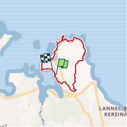
Tour Wandern von 5,8 km verfügbar auf Bretagne, Côtes-d'Armor, Perros-Guirec. Diese Tour wird von olibreizh vorgeschlagen.
Beschreibung
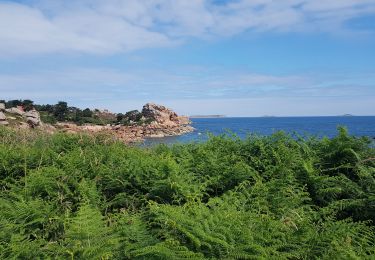
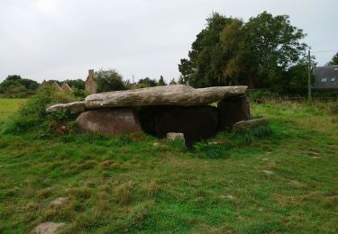
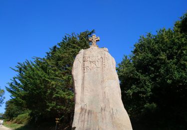
Petit tour de Ploumanac'h en passant par la côte de granit rose. Magnifiques points de vue sur la côte et les sept iles
Ort
Land:
France
Region :
Bretagne
Abteilung/Provinz :
Côtes-d'Armor
Kommune :
Perros-Guirec
Standort:
Unknown
Gehen Sie:(Dec)
Gehen Sie:(UTM)
464346 ; 5408518 (30U) N.
Kommentare
Touren in der Umgebung
![Tour Wandern Perros-Guirec - Perros-Guirec - GR34 - 11.1km 185m 2h50 - 2023 09 08 - Photo](https://media.geolcdn.com/t/375/260/d1728063-b6c3-4241-bba7-0eab61cebb20.jpg&format=jpg&maxdim=2)
![Wandern Wandern](https://static1.geolcdn.com/sitytour/trail-icons/101.png)
Perros-Guirec - GR34 - 11.1km 185m 2h50 - 2023 09 08
Wandern
Medium
(1)
Perros-Guirec,
Bretagne,
Côtes-d'Armor,
France
![](/images/other/stat-length.png)
11,1 km | 13,6 km-effort
2h 50min
![](https://static1.geolcdn.com/siteimages/upload/files/16400158638029165_repeat_loop_refresh_sync_direction_icon.png)
Ja
![Tour Wandern Trégastel - Trégastel - GR34 Île Renote Moulin à marée Chapelle de Gorgon - 13.8km 100m 3h35 - 2023 09 07 - Photo](https://media.geolcdn.com/t/375/260/f7b585bc-cd92-4f03-b6f8-635e10f5e6be.jpg&format=jpg&maxdim=2)
![Wandern Wandern](https://static1.geolcdn.com/sitytour/trail-icons/101.png)
Trégastel - GR34 Île Renote Moulin à marée Chapelle de Gorgon - 13.8km 100m 3...
Wandern
Schwierig
(2)
Trégastel,
Bretagne,
Côtes-d'Armor,
France
![](/images/other/stat-length.png)
13,8 km | 15,1 km-effort
3h 35min
![](https://static1.geolcdn.com/siteimages/upload/files/16400158638029165_repeat_loop_refresh_sync_direction_icon.png)
Ja
![Tour Wandern Perros-Guirec - la côte de granit rose à Ploumanach - Photo](https://media.geolcdn.com/t/375/260/64deb34e-d59c-4f9a-95ec-bcb98ff541ad.jpg&format=jpg&maxdim=2)
![Wandern Wandern](https://static1.geolcdn.com/sitytour/trail-icons/101.png)
la côte de granit rose à Ploumanach
Wandern
Sehr leicht
(2)
Perros-Guirec,
Bretagne,
Côtes-d'Armor,
France
![](/images/other/stat-length.png)
6 km | 6,9 km-effort
2h 38min
![](https://static1.geolcdn.com/siteimages/upload/files/16400158638029165_repeat_loop_refresh_sync_direction_icon.png)
Ja
![Tour Wandern Perros-Guirec - Les sentiers de Ploumanac'h - Photo](https://media.geolcdn.com/t/375/260/ext.jpg?maxdim=2&url=https%3A%2F%2Fservices.sitytrail.com%2FGeolivesWS%2FDownloadMedia.ashx%3FTrailID%3D317019%26Media%3D16161_1.jpg)
![Wandern Wandern](https://static1.geolcdn.com/sitytour/trail-icons/101.png)
Les sentiers de Ploumanac'h
Wandern
Medium
(2)
Perros-Guirec,
Bretagne,
Côtes-d'Armor,
France
![](/images/other/stat-length.png)
10,3 km | 12 km-effort
3h 0min
![](https://static1.geolcdn.com/siteimages/upload/files/16400158638029165_repeat_loop_refresh_sync_direction_icon.png)
Ja
![Tour Wandern Louannec - Louannec - GR34 PR - 11.5km 185m 3h00 (40mn) - 2023 09 14 - Photo](https://media.geolcdn.com/t/375/260/e980ede6-67ca-4aa3-94c9-619423761500.jpg&format=jpg&maxdim=2)
![Wandern Wandern](https://static1.geolcdn.com/sitytour/trail-icons/101.png)
Louannec - GR34 PR - 11.5km 185m 3h00 (40mn) - 2023 09 14
Wandern
Schwierig
Louannec,
Bretagne,
Côtes-d'Armor,
France
![](/images/other/stat-length.png)
11,5 km | 13,9 km-effort
3h 0min
![](https://static1.geolcdn.com/siteimages/upload/files/16400158638029165_repeat_loop_refresh_sync_direction_icon.png)
Ja
![Tour Wandern Trégastel - Trégastel - GR34 Ploumanac'h Kasino de Perros-Guirec - 11.7km 200m 2h55 (50mn) - 2023 09 08 - Photo](https://media.geolcdn.com/t/375/260/3132b43e-4920-4682-bf35-15b1d429cbae.jpg&format=jpg&maxdim=2)
![Wandern Wandern](https://static1.geolcdn.com/sitytour/trail-icons/101.png)
Trégastel - GR34 Ploumanac'h Kasino de Perros-Guirec - 11.7km 200m 2h55 (50mn...
Wandern
Medium
Trégastel,
Bretagne,
Côtes-d'Armor,
France
![](/images/other/stat-length.png)
11,7 km | 14,4 km-effort
2h 55min
![](https://static1.geolcdn.com/siteimages/upload/files/16400158638029165_repeat_loop_refresh_sync_direction_icon.png)
Ja
![Tour Wandern Pleumeur-Bodou - Pleumeur-Bodou - GR34 Presqu'île de Landrellec - 11km 90m 2h40 (55mn) - 2023 09 07 - Photo](https://media.geolcdn.com/t/375/260/8535d7bc-c32f-4d63-8654-21c356641e89.jpg&format=jpg&maxdim=2)
![Wandern Wandern](https://static1.geolcdn.com/sitytour/trail-icons/101.png)
Pleumeur-Bodou - GR34 Presqu'île de Landrellec - 11km 90m 2h40 (55mn) - 2023 ...
Wandern
Medium
Pleumeur-Bodou,
Bretagne,
Côtes-d'Armor,
France
![](/images/other/stat-length.png)
11 km | 12,2 km-effort
2h 40min
![](https://static1.geolcdn.com/siteimages/upload/files/16400158638029165_repeat_loop_refresh_sync_direction_icon.png)
Ja
![Tour Wandern Pleumeur-Bodou - Pleumeur-Bodou - GR34 Chapelle Saint-Samson - 7.7km 60m 1h55 - 2023 09 06 - Photo](https://media.geolcdn.com/t/375/260/5d74374c-67e8-400e-845c-98d92708147a.jpg&format=jpg&maxdim=2)
![Wandern Wandern](https://static1.geolcdn.com/sitytour/trail-icons/101.png)
Pleumeur-Bodou - GR34 Chapelle Saint-Samson - 7.7km 60m 1h55 - 2023 09 06
Wandern
Medium
Pleumeur-Bodou,
Bretagne,
Côtes-d'Armor,
France
![](/images/other/stat-length.png)
7,7 km | 8,5 km-effort
1h 55min
![](https://static1.geolcdn.com/siteimages/upload/files/16400158638029165_repeat_loop_refresh_sync_direction_icon.png)
Ja
![Tour Wandern Pleumeur-Bodou - Pleumeur-Bodou - GR34 Menhir de Saint-Uzec Chapelle de Penvern - 5.6km 60m 1h20 (40mn) - 2023 09 06 - Photo](https://media.geolcdn.com/t/375/260/acb169dc-b395-42f6-b477-bf2c7a0dcada.jpg&format=jpg&maxdim=2)
![Wandern Wandern](https://static1.geolcdn.com/sitytour/trail-icons/101.png)
Pleumeur-Bodou - GR34 Menhir de Saint-Uzec Chapelle de Penvern - 5.6km 60m 1h...
Wandern
Einfach
Pleumeur-Bodou,
Bretagne,
Côtes-d'Armor,
France
![](/images/other/stat-length.png)
5,6 km | 6,4 km-effort
1h 20min
![](https://static1.geolcdn.com/siteimages/upload/files/16400158638029165_repeat_loop_refresh_sync_direction_icon.png)
Ja