Startseite
World
NEW
Premium
Speichern Sie
Touren
Artikel
Hilfe - Unterstützung
Français
English
Nederlands
Español
Italiano
Deutsch
Verbindung
Startseite
World
Premium
Speichern Sie
Touren
Artikel
Hilfe - Unterstützung
SityTrail
>
POIs
>
GC160YY
SityTrail
>
POIs
>
GC160YY
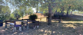
GC160YY
Beschreibung
La chapelle Saint Vincent by a
Foto-Galerie
Erkunden Sie GC160YY mit den folgenden Touren...
tracegps
Crêt Coquet
Wandern
Medium
(3)
Hautecour, Auvergne-Rhone-Alpen, Savoyen, France
6,5 km | 9,6 km-effort
3h 30min
Ja
tracegps
Benutzer
©
OpenStreetMap
contributors
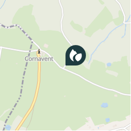
Ort
Land:
France
Region :
Auvergne-Rhone-Alpen
Abteilung/Provinz :
Rhône
Kommune :
Saint-Laurent-d'Agny
Standort:
Unknown
Ort
45.649167 / 4.662067
Erstellungsdatum :
2018-04-09 12:18:19.712
Letzte Änderung
2018-04-09 12:18:19.712
(0 Nachricht)
Kommentare
Bitte melden Sie sich an, um einen Kommentar oder eine Bewertung zu hinterlassen
POI's in der Nähe
tracegps
GC160YY
SAINT-LAURENT-D'AGNY
tracegps
GC160YY
SAINT-LAURENT-D'AGNY
tracegps
GC160YY
SAINT-LAURENT-D'AGNY
tracegps
GC160YY
SAINT-LAURENT-D'AGNY
Valery01
perdu iphone
CHAUSSAN
tracegps
GC1CYZN
RONTALON
galain
Table pique-nique
CHAUSSAN
galain
aire de pique-nique
CHAUSSAN
Schließen
Meine Abonnements