Startseite
World
NEW
Premium
Speichern Sie
Touren
Artikel
Hilfe - Unterstützung
Français
English
Nederlands
Español
Italiano
Deutsch
Verbindung
Startseite
World
Premium
Speichern Sie
Touren
Artikel
Hilfe - Unterstützung
SityTrail
>
POIs
>
GCW1C2
SityTrail
>
POIs
>
GCW1C2
GCW1C2
Beschreibung
La Cheminée by micka38, Tradit
Foto-Galerie
Erkunden Sie GCW1C2 mit den folgenden Touren...
tracegps
Mont-Jovet depuis La Cour
Wandern
Schwierig
(1)
Bozel, Auvergne-Rhone-Alpen, Savoyen, France
13,5 km | 27 km-effort
6h 0min
Ja
tracegps
Benutzer
©
OpenStreetMap
contributors
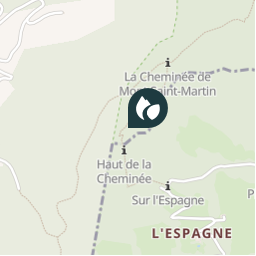
Ort
Land:
France
Region :
Auvergne-Rhone-Alpen
Abteilung/Provinz :
Isère
Kommune :
Voreppe
Standort:
Unknown
Ort
45.27935 / 5.66925
Erstellungsdatum :
2018-04-09 12:21:44.755
Letzte Änderung
2018-04-09 12:21:44.755
(0 Nachricht)
Kommentare
Bitte melden Sie sich an, um einen Kommentar oder eine Bewertung zu hinterlassen
POI's in der Nähe
tracegps
GCW1C2
VOREPPE
tracegps
GCW1C2
VOREPPE
tracegps
GCW1C2
VOREPPE
tracegps
GCW1C2
VOREPPE
tracegps
GCW1C2
VOREPPE
tracegps
GCW1C2
VOREPPE
tracegps
GCW1C2
VOREPPE
tracegps
GCW1C2
VOREPPE
Schließen
Meine Abonnements