POI Gaudonville -  - Photo

Beschreibung

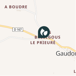
Arrivé à l’intersection de la D167, continuer sur 50m sur la départementale. Prendre à gauche aux "Bresegous", continuer tout droit et descendre le chemin jusqu’à "St-André" puis remonter jusqu’à "la Bastide".

Foto-Galerie

Erkunden Sie mit den folgenden Touren...
Tour Wandern Saint-Clar - PR10+equi - Photo
Wandern
mvh47

Wandern

Sehr leicht
Saint-Clar, Okzitanien, Gers, France
199 km | 242 km-effort
10h 20min
Nein
 mvh47
mvh47

Benutzer

© OpenStreetMap contributors

Ort

Land:
France
Region :
Okzitanien
Abteilung/Provinz :
Gers
Kommune :
Gaudonville
Standort:
Unknown
Erstellungsdatum :
2018-04-11 08:50:37.854
Letzte Änderung
2018-04-11 08:50:37.854

(0 Nachricht)


POI's in der Nähe

POI Gaudonville -  - Photo
mvh47
GAUDONVILLE 
POI Gaudonville -  - Photo
mvh47
GAUDONVILLE 
POI Gaudonville -  - Photo
mvh47
GAUDONVILLE 
POI Gaudonville -  - Photo
mvh47
GAUDONVILLE 
POI Gaudonville -  - Photo
mvh47
GAUDONVILLE 
POI Gaudonville -  - Photo
mvh47
GAUDONVILLE 
POI Gaudonville -  - Photo
mvh47
GAUDONVILLE 
POI Mauroux -  - Photo
mvh47
MAUROUX 


Schließen
Meine Abonnements