![](/images/other/stat-length.png)
Landkreis Marburg-Biedenkopf, Hessen: Die besten Touren, Trails, Trecks und Wanderungen
Landkreis Marburg-Biedenkopf : Entdecken Sie die besten Touren : 103 zu Fuß und 1 mit dem Fahrrad oder Mountainbike. Alle diese Touren, Trails, Routen und Outdoor-Aktivitäten sind in unseren SityTrail-Apps für Smartphones und Tablets verfügbar.
Die besten Spuren (104)
![Tour Zu Fuß Marburg - Strumpfweg - Photo](https://media.geolcdn.com/t/350/260/d1aec3c4-86e8-4224-afdb-6ee00ea71aad.jpeg&format=jpg&maxdim=2)
![Zu Fuß Zu Fuß](https://static1.geolcdn.com/sitytour/trail-icons/100.png)
Km
Zu Fuß
![](/images/other/stat-length.png)
![](https://static1.geolcdn.com/siteimages/upload/files/1508320355ic_sort_den_pos_24dp.png)
![](https://static1.geolcdn.com/siteimages/upload/files/1508320355ic_sort_den_neg_24dp.png)
![](https://static1.geolcdn.com/siteimages/upload/files/16400158638029165_repeat_loop_refresh_sync_direction_icon.png)
• Trail created by Oberhessischer Gebirgsverein. Symbol: Rotes Quadrat auf weißem Grund
![Tour Zu Fuß Bad Endbach - Extratour Viertälerweg - Photo](https://media.geolcdn.com/t/350/260/767d0355-412c-449d-99be-38e94380dd15.jpeg&format=jpg&maxdim=2)
![Zu Fuß Zu Fuß](https://static1.geolcdn.com/sitytour/trail-icons/100.png)
Km
Zu Fuß
![](/images/other/stat-length.png)
![](https://static1.geolcdn.com/siteimages/upload/files/1508320355ic_sort_den_pos_24dp.png)
![](https://static1.geolcdn.com/siteimages/upload/files/1508320355ic_sort_den_neg_24dp.png)
![](https://static1.geolcdn.com/siteimages/upload/files/16400158638029165_repeat_loop_refresh_sync_direction_icon.png)
• Trail created by Naturpark Lahn-Dill-Bergland. Symbol: stilisierter Berg und Fluß in Grün auf weißem Grund
![Tour Zu Fuß Angelburg - Extratour Hirzenhainer Höhenflug - Photo](https://media.geolcdn.com/t/350/260/de6a58be-6e21-48ee-8973-af3130c1b97d.jpeg&format=jpg&maxdim=2)
![Zu Fuß Zu Fuß](https://static1.geolcdn.com/sitytour/trail-icons/100.png)
Km
Zu Fuß
![](/images/other/stat-length.png)
![](https://static1.geolcdn.com/siteimages/upload/files/1508320355ic_sort_den_pos_24dp.png)
![](https://static1.geolcdn.com/siteimages/upload/files/1508320355ic_sort_den_neg_24dp.png)
![](https://static1.geolcdn.com/siteimages/upload/files/16400158638029165_repeat_loop_refresh_sync_direction_icon.png)
• Trail created by Naturpark Lahn-Dill-Bergland. Symbol: stilisierter Berg und Fluß in Grün auf weißem Grund
![Tour Zu Fuß Steffenberg - Extratour Hörlepanoramaweg - Photo](https://media.geolcdn.com/t/350/260/c81d0eb1-0e5d-41ee-ac14-153acc603793.jpeg&format=jpg&maxdim=2)
![Zu Fuß Zu Fuß](https://static1.geolcdn.com/sitytour/trail-icons/100.png)
Km
Zu Fuß
![](/images/other/stat-length.png)
![](https://static1.geolcdn.com/siteimages/upload/files/1508320355ic_sort_den_pos_24dp.png)
![](https://static1.geolcdn.com/siteimages/upload/files/1508320355ic_sort_den_neg_24dp.png)
![](https://static1.geolcdn.com/siteimages/upload/files/16400158638029165_repeat_loop_refresh_sync_direction_icon.png)
• Trail created by Naturpark Lahn-Dill-Bergland. Symbol: stilisierter Berg und Fluß in Grün auf weißem Grund
![Tour Zu Fuß Amöneburg - Geotour Stock & Stein - Photo](https://media.geolcdn.com/t/350/260/51ede76e-a483-4b4b-a1e1-b7d1785eccce.jpeg&format=jpg&maxdim=2)
![Zu Fuß Zu Fuß](https://static1.geolcdn.com/sitytour/trail-icons/100.png)
Km
Zu Fuß
![](/images/other/stat-length.png)
![](https://static1.geolcdn.com/siteimages/upload/files/1508320355ic_sort_den_pos_24dp.png)
![](https://static1.geolcdn.com/siteimages/upload/files/1508320355ic_sort_den_neg_24dp.png)
![](https://static1.geolcdn.com/siteimages/upload/files/16400158638029165_repeat_loop_refresh_sync_direction_icon.png)
• Trail created by Stadt Amöneburg.
![Tour Zu Fuß Stadtallendorf - Geotour Kreuz & Quer - Photo](https://media.geolcdn.com/t/350/260/8f447771-e6a0-4782-b1e3-78814c692840.jpeg&format=jpg&maxdim=2)
![Zu Fuß Zu Fuß](https://static1.geolcdn.com/sitytour/trail-icons/100.png)
Km
Zu Fuß
![](/images/other/stat-length.png)
![](https://static1.geolcdn.com/siteimages/upload/files/1508320355ic_sort_den_pos_24dp.png)
![](https://static1.geolcdn.com/siteimages/upload/files/1508320355ic_sort_den_neg_24dp.png)
![](https://static1.geolcdn.com/siteimages/upload/files/16400158638029165_repeat_loop_refresh_sync_direction_icon.png)
• Trail created by Stadt Amöneburg.
![Tour Zu Fuß Lahntal - Naturlehrpfad Goßfelden - Photo](https://media.geolcdn.com/t/350/260/e6bd8143-89a8-45f9-80ec-1b8bb9e5b5bb.jpeg&format=jpg&maxdim=2)
![Zu Fuß Zu Fuß](https://static1.geolcdn.com/sitytour/trail-icons/100.png)
Km
Zu Fuß
![](/images/other/stat-length.png)
![](https://static1.geolcdn.com/siteimages/upload/files/1508320355ic_sort_den_pos_24dp.png)
![](https://static1.geolcdn.com/siteimages/upload/files/1508320355ic_sort_den_neg_24dp.png)
![](https://static1.geolcdn.com/siteimages/upload/files/16400158638029165_repeat_loop_refresh_sync_direction_icon.png)
• Trail created by NaBu Marburg-Biedenkopf.
![Tour Zu Fuß Gladenbach - Extratour Postraubroute - Photo](https://media.geolcdn.com/t/350/260/2e5e3f6a-716e-4e97-af2a-b06bf33fb9c3.jpeg&format=jpg&maxdim=2)
![Zu Fuß Zu Fuß](https://static1.geolcdn.com/sitytour/trail-icons/100.png)
Km
Zu Fuß
![](/images/other/stat-length.png)
![](https://static1.geolcdn.com/siteimages/upload/files/1508320355ic_sort_den_pos_24dp.png)
![](https://static1.geolcdn.com/siteimages/upload/files/1508320355ic_sort_den_neg_24dp.png)
![](https://static1.geolcdn.com/siteimages/upload/files/16400158638029165_repeat_loop_refresh_sync_direction_icon.png)
• Trail created by Naturpark Lahn-Dill-Bergland. Symbol: stilisierter Berg und Fluß in Grün auf weißem Grund
![Tour Zu Fuß Lohra - Extratour Schauinsland - Photo](https://media.geolcdn.com/t/350/260/b42a61d7-217c-4fcc-a27b-1a5bf3fd2525.jpeg&format=jpg&maxdim=2)
![Zu Fuß Zu Fuß](https://static1.geolcdn.com/sitytour/trail-icons/100.png)
Km
Zu Fuß
![](/images/other/stat-length.png)
![](https://static1.geolcdn.com/siteimages/upload/files/1508320355ic_sort_den_pos_24dp.png)
![](https://static1.geolcdn.com/siteimages/upload/files/1508320355ic_sort_den_neg_24dp.png)
![](https://static1.geolcdn.com/siteimages/upload/files/16400158638029165_repeat_loop_refresh_sync_direction_icon.png)
• Trail created by Naturpark Lahn-Dill-Bergland. Symbol: stilisierter Berg und Fluß in Grün auf weißem Grund
![Tour Zu Fuß Dautphetal - Hollende Rundweg - Photo](https://media.geolcdn.com/t/350/260/50e7b00a-ff6b-4f18-bc7b-20f9b76f94b8.jpeg&format=jpg&maxdim=2)
![Zu Fuß Zu Fuß](https://static1.geolcdn.com/sitytour/trail-icons/100.png)
Km
Zu Fuß
![](/images/other/stat-length.png)
![](https://static1.geolcdn.com/siteimages/upload/files/1508320355ic_sort_den_pos_24dp.png)
![](https://static1.geolcdn.com/siteimages/upload/files/1508320355ic_sort_den_neg_24dp.png)
![](https://static1.geolcdn.com/siteimages/upload/files/16400158638029165_repeat_loop_refresh_sync_direction_icon.png)
• Trail created by Wanderfreunde Treisbach.
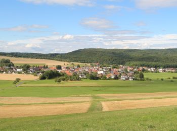
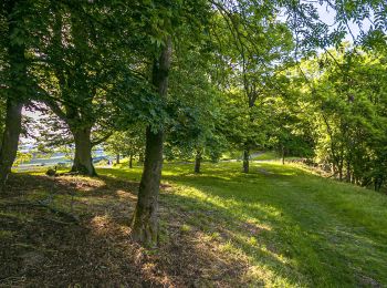
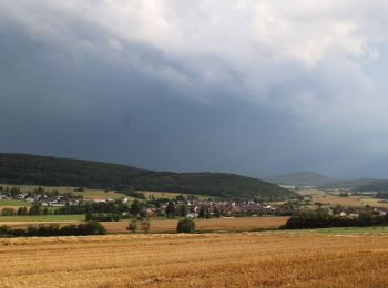
![Tour Zu Fuß Wetter - [W2] Kleine Wollenbergrunde (Wetschaft Senke) - Photo](https://media.geolcdn.com/t/350/260/daed682b-00fa-4e8a-8c85-f140ab90c6d6.jpeg&format=jpg&maxdim=2)
![Zu Fuß Zu Fuß](https://static1.geolcdn.com/sitytour/trail-icons/100.png)
Km
Zu Fuß
![](/images/other/stat-length.png)
![](https://static1.geolcdn.com/siteimages/upload/files/1508320355ic_sort_den_pos_24dp.png)
![](https://static1.geolcdn.com/siteimages/upload/files/1508320355ic_sort_den_neg_24dp.png)
![](https://static1.geolcdn.com/siteimages/upload/files/16400158638029165_repeat_loop_refresh_sync_direction_icon.png)
• Trail created by Wandcerverein Wetter (Hessen). Symbol: Gelbe Bezeichnung W2 auf schwarzem Grund
![Tour Zu Fuß Wetter - [W1] Wollenberg Rundwanderweg - Photo](https://media.geolcdn.com/t/350/260/daed682b-00fa-4e8a-8c85-f140ab90c6d6.jpeg&format=jpg&maxdim=2)
![Zu Fuß Zu Fuß](https://static1.geolcdn.com/sitytour/trail-icons/100.png)
Km
Zu Fuß
![](/images/other/stat-length.png)
![](https://static1.geolcdn.com/siteimages/upload/files/1508320355ic_sort_den_pos_24dp.png)
![](https://static1.geolcdn.com/siteimages/upload/files/1508320355ic_sort_den_neg_24dp.png)
![](https://static1.geolcdn.com/siteimages/upload/files/16400158638029165_repeat_loop_refresh_sync_direction_icon.png)
• Trail created by Wandcerverein Wetter (Hessen). Symbol: Gelbe Bezeichnung W1 auf schwarzem Grund
![Tour Zu Fuß Dautphetal - Lahnhöhen-Extratour - Photo](https://media.geolcdn.com/t/350/260/c0d511c7-e0ad-4328-a124-aba342f31e32.jpeg&format=jpg&maxdim=2)
![Zu Fuß Zu Fuß](https://static1.geolcdn.com/sitytour/trail-icons/100.png)
Km
Zu Fuß
![](/images/other/stat-length.png)
![](https://static1.geolcdn.com/siteimages/upload/files/1508320355ic_sort_den_pos_24dp.png)
![](https://static1.geolcdn.com/siteimages/upload/files/1508320355ic_sort_den_neg_24dp.png)
![](https://static1.geolcdn.com/siteimages/upload/files/16400158638029165_repeat_loop_refresh_sync_direction_icon.png)
• Trail created by Naturpark Lahn-Dill-Bergland. Symbol: stilisierter Berg und Fluß in Grün auf weißem Grund
![Tour Zu Fuß Dautphetal - Extratour Streuobstroute - Photo](https://media.geolcdn.com/t/350/260/02f60986-5fc0-4f9b-b6f3-d9ee3470b9f4.jpeg&format=jpg&maxdim=2)
![Zu Fuß Zu Fuß](https://static1.geolcdn.com/sitytour/trail-icons/100.png)
Km
Zu Fuß
![](/images/other/stat-length.png)
![](https://static1.geolcdn.com/siteimages/upload/files/1508320355ic_sort_den_pos_24dp.png)
![](https://static1.geolcdn.com/siteimages/upload/files/1508320355ic_sort_den_neg_24dp.png)
![](https://static1.geolcdn.com/siteimages/upload/files/16400158638029165_repeat_loop_refresh_sync_direction_icon.png)
• Trail created by Naturpark Lahn-Dill-Bergland. Symbol: stilisierter Berg und Fluß in Grün auf weißem Grund
![Tour Zu Fuß Ebsdorfergrund - Ebsdorfergrund-Weg - Photo](https://media.geolcdn.com/t/350/260/34d3676f-192d-4d36-96b2-ea81f169f7fb.jpeg&format=jpg&maxdim=2)
![Zu Fuß Zu Fuß](https://static1.geolcdn.com/sitytour/trail-icons/100.png)
Km
Zu Fuß
![](/images/other/stat-length.png)
![](https://static1.geolcdn.com/siteimages/upload/files/1508320355ic_sort_den_pos_24dp.png)
![](https://static1.geolcdn.com/siteimages/upload/files/1508320355ic_sort_den_neg_24dp.png)
![](https://static1.geolcdn.com/siteimages/upload/files/16400158638029165_repeat_loop_refresh_sync_direction_icon.png)
• Trail created by Oberhessischer Gebirgsverein. Symbol: Blaues Dreieck auf weißem Grund
![Tour Zu Fuß Weimar (Lahn) - Naturerlebnispfad Niederwalgern - Photo](https://media.geolcdn.com/t/350/260/2fcf05ab-bf8a-461d-a25b-c1b8172c29a1.jpeg&format=jpg&maxdim=2)
![Zu Fuß Zu Fuß](https://static1.geolcdn.com/sitytour/trail-icons/100.png)
Km
Zu Fuß
![](/images/other/stat-length.png)
![](https://static1.geolcdn.com/siteimages/upload/files/1508320355ic_sort_den_pos_24dp.png)
![](https://static1.geolcdn.com/siteimages/upload/files/1508320355ic_sort_den_neg_24dp.png)
![](https://static1.geolcdn.com/siteimages/upload/files/16400158638029165_repeat_loop_refresh_sync_direction_icon.png)
• Trail created by Heinzelmännchen Niederwalgern. Symbol: Roter Punkt auf gelbem Hintergrund
![Tour Zu Fuß Marburg - Homberger Weg - Photo](https://media.geolcdn.com/t/350/260/75a790db-16aa-4783-b4c0-7d44c0ff928b.jpeg&format=jpg&maxdim=2)
![Zu Fuß Zu Fuß](https://static1.geolcdn.com/sitytour/trail-icons/100.png)
Km
Zu Fuß
![](/images/other/stat-length.png)
![](https://static1.geolcdn.com/siteimages/upload/files/1508320355ic_sort_den_pos_24dp.png)
![](https://static1.geolcdn.com/siteimages/upload/files/1508320355ic_sort_den_neg_24dp.png)
![](https://static1.geolcdn.com/siteimages/upload/files/16400158638029165_repeat_loop_refresh_sync_direction_icon.png)
• Trail created by Oberhessischer Gebirgsverein. Symbol: Blaues Quadrat auf weißem Grund
![Tour Zu Fuß Gladenbach - [G7] - Rundweg Gladenbach - Mornshausen - Hüttenmühle - Subach - Teufelsberg - Koppe - Mornshausen - Gladenbach - Photo](https://media.geolcdn.com/t/350/260/2e5e3f6a-716e-4e97-af2a-b06bf33fb9c3.jpeg&format=jpg&maxdim=2)
![Zu Fuß Zu Fuß](https://static1.geolcdn.com/sitytour/trail-icons/100.png)
Km
Zu Fuß
![](/images/other/stat-length.png)
![](https://static1.geolcdn.com/siteimages/upload/files/1508320355ic_sort_den_pos_24dp.png)
![](https://static1.geolcdn.com/siteimages/upload/files/1508320355ic_sort_den_neg_24dp.png)
![](https://static1.geolcdn.com/siteimages/upload/files/16400158638029165_repeat_loop_refresh_sync_direction_icon.png)
• Trail created by Oberhessischer Gebirgsverein. Symbol: Gelber Text "G7" auf schwarzem Hintergrund
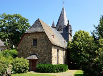
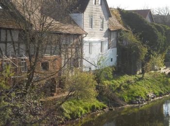
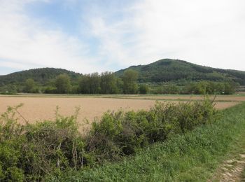
![Tour Zu Fuß Gladenbach - [G4] - Rundweg Gladenbach - Reithalle - alter Pflanzengarten - Rachelshausen - Kehlnbach - Kehlnbachtal - Gladenbach - Photo](https://media.geolcdn.com/t/350/260/5102141e-d951-49fc-98e6-521cd239ef3d.jpeg&format=jpg&maxdim=2)
![Zu Fuß Zu Fuß](https://static1.geolcdn.com/sitytour/trail-icons/100.png)
Km
Zu Fuß
![](/images/other/stat-length.png)
![](https://static1.geolcdn.com/siteimages/upload/files/1508320355ic_sort_den_pos_24dp.png)
![](https://static1.geolcdn.com/siteimages/upload/files/1508320355ic_sort_den_neg_24dp.png)
![](https://static1.geolcdn.com/siteimages/upload/files/16400158638029165_repeat_loop_refresh_sync_direction_icon.png)
• Trail created by Oberhessischer Gebirgsverein. Symbol: Gelber Text "G4" auf schwarzem Hintergrund
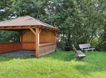
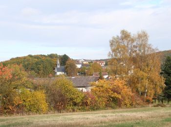
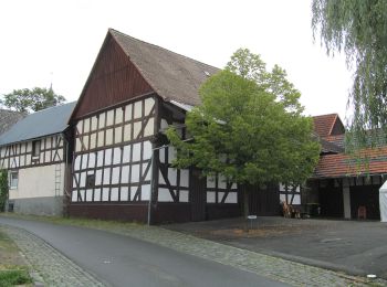
![Tour Zu Fuß Gladenbach - [G12] - Rundweg Gladenbach - Ruine Blankenstein - Kehlnbach - Römershausen - Rachelshausen - Runzhausen - Schutzhütte Kehlnbach - Gladenbach - Photo](https://media.geolcdn.com/t/350/260/9a55fbee-7b56-4a3a-8921-e1e04f3645be.jpeg&format=jpg&maxdim=2)
![Zu Fuß Zu Fuß](https://static1.geolcdn.com/sitytour/trail-icons/100.png)
Km
Zu Fuß
![](/images/other/stat-length.png)
![](https://static1.geolcdn.com/siteimages/upload/files/1508320355ic_sort_den_pos_24dp.png)
![](https://static1.geolcdn.com/siteimages/upload/files/1508320355ic_sort_den_neg_24dp.png)
![](https://static1.geolcdn.com/siteimages/upload/files/16400158638029165_repeat_loop_refresh_sync_direction_icon.png)
• Trail created by Oberhessischer Gebirgsverein. Symbol: Gelber Text "G12" auf schwarzem Hintergrund
20 Angezeigte Touren bei 104
Kostenlosegpshiking-Anwendung