![](/images/other/stat-length.png)
- Touren
- Outdoor
- Germany
- Rheinland-Pfalz
- Landkreis Bernkastel-Wittlich
Landkreis Bernkastel-Wittlich, Rheinland-Pfalz: Die besten Touren, Trails, Trecks und Wanderungen
Landkreis Bernkastel-Wittlich : Entdecken Sie die besten Touren : 108 zu Fuß und 1 mit dem Fahrrad oder Mountainbike. Alle diese Touren, Trails, Routen und Outdoor-Aktivitäten sind in unseren SityTrail-Apps für Smartphones und Tablets verfügbar.
Die besten Spuren (114)
![Tour Zu Fuß Bernkastel-Kues - Moselsteig Seitensprung Bernkasteler Bärensteig - Photo](https://media.geolcdn.com/t/350/260/7fd007be-cf57-41d6-aef3-4b117491e3df.jpeg&format=jpg&maxdim=2)
![Zu Fuß Zu Fuß](https://static1.geolcdn.com/sitytour/trail-icons/100.png)
Km
Zu Fuß
![](/images/other/stat-length.png)
![](https://static1.geolcdn.com/siteimages/upload/files/1508320355ic_sort_den_pos_24dp.png)
![](https://static1.geolcdn.com/siteimages/upload/files/1508320355ic_sort_den_neg_24dp.png)
![](https://static1.geolcdn.com/siteimages/upload/files/16400158638029165_repeat_loop_refresh_sync_direction_icon.png)
• Trail created by Mosellandtouristik HmbH.
![Tour Zu Fuß Veldenz - Jakob-Maria-Mierscheid-Weg - Photo](https://media.geolcdn.com/t/350/260/df270117-5716-49f6-92b3-8d70da3fb659.jpeg&format=jpg&maxdim=2)
![Zu Fuß Zu Fuß](https://static1.geolcdn.com/sitytour/trail-icons/100.png)
Km
Zu Fuß
![](/images/other/stat-length.png)
![](https://static1.geolcdn.com/siteimages/upload/files/1508320355ic_sort_den_pos_24dp.png)
![](https://static1.geolcdn.com/siteimages/upload/files/1508320355ic_sort_den_neg_24dp.png)
![](https://static1.geolcdn.com/siteimages/upload/files/16400158638029165_repeat_loop_refresh_sync_direction_icon.png)
• Symbol: stilisiertes S und H auf lila Grund, darunter Brille und Bart
![Tour Zu Fuß Mülheim an der Mosel - Ponoramaweg - Photo](https://media.geolcdn.com/t/350/260/8ee021a1-10e3-4c58-8032-bbec2df5a624.jpeg&format=jpg&maxdim=2)
![Zu Fuß Zu Fuß](https://static1.geolcdn.com/sitytour/trail-icons/100.png)
Km
Zu Fuß
![](/images/other/stat-length.png)
![](https://static1.geolcdn.com/siteimages/upload/files/1508320355ic_sort_den_pos_24dp.png)
![](https://static1.geolcdn.com/siteimages/upload/files/1508320355ic_sort_den_neg_24dp.png)
![](https://static1.geolcdn.com/siteimages/upload/files/16400158638029165_repeat_loop_refresh_sync_direction_icon.png)
• Trail created by Gemeinde Mülheim an der Mosel Haupt-Reiter. Symbol: Rotes Herz Zeichen mit stilistischen Weintrauben
![Tour Zu Fuß Graach an der Mosel - Himmelreich Wanderweg - Photo](https://media.geolcdn.com/t/350/260/9a2018db-0271-4a75-a325-1dba57651056.jpeg&format=jpg&maxdim=2)
![Zu Fuß Zu Fuß](https://static1.geolcdn.com/sitytour/trail-icons/100.png)
Km
Zu Fuß
![](/images/other/stat-length.png)
![](https://static1.geolcdn.com/siteimages/upload/files/1508320355ic_sort_den_pos_24dp.png)
![](https://static1.geolcdn.com/siteimages/upload/files/1508320355ic_sort_den_neg_24dp.png)
![](https://static1.geolcdn.com/siteimages/upload/files/16400158638029165_repeat_loop_refresh_sync_direction_icon.png)
• Symbol: braunes Herz mit Traube
![Tour Zu Fuß Zeltingen-Rachtig - Deutschherrenweg - Photo](https://media.geolcdn.com/t/350/260/bcc61c58-051e-4deb-81d2-9b2813021b78.jpeg&format=jpg&maxdim=2)
![Zu Fuß Zu Fuß](https://static1.geolcdn.com/sitytour/trail-icons/100.png)
Km
Zu Fuß
![](/images/other/stat-length.png)
![](https://static1.geolcdn.com/siteimages/upload/files/1508320355ic_sort_den_pos_24dp.png)
![](https://static1.geolcdn.com/siteimages/upload/files/1508320355ic_sort_den_neg_24dp.png)
![](https://static1.geolcdn.com/siteimages/upload/files/16400158638029165_repeat_loop_refresh_sync_direction_icon.png)
• Symbol: braunes Herz mit Trauben
![Tour Zu Fuß Bernkastel-Kues - Burg-Olymp-Tour - Photo](https://media.geolcdn.com/t/350/260/e86d356a-6b4f-4ee9-ba9b-aab206be3c9b.jpeg&format=jpg&maxdim=2)
![Zu Fuß Zu Fuß](https://static1.geolcdn.com/sitytour/trail-icons/100.png)
Km
Zu Fuß
![](/images/other/stat-length.png)
![](https://static1.geolcdn.com/siteimages/upload/files/1508320355ic_sort_den_pos_24dp.png)
![](https://static1.geolcdn.com/siteimages/upload/files/1508320355ic_sort_den_neg_24dp.png)
![](https://static1.geolcdn.com/siteimages/upload/files/16400158638029165_repeat_loop_refresh_sync_direction_icon.png)
• Symbol: braunes Herz mit Traube
![Tour Zu Fuß Erden - Kletterweg Erdener Treppchen - Photo](https://media.geolcdn.com/t/350/260/ba5d4de8-2450-49d0-a88f-95a8b5e3c72c.jpeg&format=jpg&maxdim=2)
![Zu Fuß Zu Fuß](https://static1.geolcdn.com/sitytour/trail-icons/100.png)
Km
Zu Fuß
![](/images/other/stat-length.png)
![](https://static1.geolcdn.com/siteimages/upload/files/1508320355ic_sort_den_pos_24dp.png)
![](https://static1.geolcdn.com/siteimages/upload/files/1508320355ic_sort_den_neg_24dp.png)
![](https://static1.geolcdn.com/siteimages/upload/files/16400158638029165_repeat_loop_refresh_sync_direction_icon.png)
• Symbol: gelber Punkt
![Tour Zu Fuß Kröv - Rundweg: Judenfriedhof - Weinlehrpfad - Kesselstattkapelle - zurück - Photo](https://media.geolcdn.com/t/350/260/b2f66696-89ab-484f-9d0f-e7747e4ce6a0.jpeg&format=jpg&maxdim=2)
![Zu Fuß Zu Fuß](https://static1.geolcdn.com/sitytour/trail-icons/100.png)
Km
Zu Fuß
![](/images/other/stat-length.png)
![](https://static1.geolcdn.com/siteimages/upload/files/1508320355ic_sort_den_pos_24dp.png)
![](https://static1.geolcdn.com/siteimages/upload/files/1508320355ic_sort_den_neg_24dp.png)
![](https://static1.geolcdn.com/siteimages/upload/files/16400158638029165_repeat_loop_refresh_sync_direction_icon.png)
• Trail created by Tourist-Information Kröv. Symbol: blauer Punkt
![Tour Zu Fuß Kröv - Panorama-Rundweg und Schieferpfad - Photo](https://media.geolcdn.com/t/350/260/ff44ceb2-b663-46bb-a8ea-86fa716c9507.jpeg&format=jpg&maxdim=2)
![Zu Fuß Zu Fuß](https://static1.geolcdn.com/sitytour/trail-icons/100.png)
Km
Zu Fuß
![](/images/other/stat-length.png)
![](https://static1.geolcdn.com/siteimages/upload/files/1508320355ic_sort_den_pos_24dp.png)
![](https://static1.geolcdn.com/siteimages/upload/files/1508320355ic_sort_den_neg_24dp.png)
![](https://static1.geolcdn.com/siteimages/upload/files/16400158638029165_repeat_loop_refresh_sync_direction_icon.png)
• Trail created by Tourist-Information Kröv. Symbol: roter Punkt
![Tour Zu Fuß Erden - Kletterweg Erdener Treppchen - Photo](https://media.geolcdn.com/t/350/260/ba5d4de8-2450-49d0-a88f-95a8b5e3c72c.jpeg&format=jpg&maxdim=2)
![Zu Fuß Zu Fuß](https://static1.geolcdn.com/sitytour/trail-icons/100.png)
Km
Zu Fuß
![](/images/other/stat-length.png)
![](https://static1.geolcdn.com/siteimages/upload/files/1508320355ic_sort_den_pos_24dp.png)
![](https://static1.geolcdn.com/siteimages/upload/files/1508320355ic_sort_den_neg_24dp.png)
![](https://static1.geolcdn.com/siteimages/upload/files/16400158638029165_repeat_loop_refresh_sync_direction_icon.png)
• Symbol: roter Punkt
![Tour Zu Fuß Bernkastel-Kues - Maria-Zill Panoramaweg - Photo](https://media.geolcdn.com/t/350/260/15bb359e-f5c6-4839-a503-d329f9327324.jpeg&format=jpg&maxdim=2)
![Zu Fuß Zu Fuß](https://static1.geolcdn.com/sitytour/trail-icons/100.png)
Km
Zu Fuß
![](/images/other/stat-length.png)
![](https://static1.geolcdn.com/siteimages/upload/files/1508320355ic_sort_den_pos_24dp.png)
![](https://static1.geolcdn.com/siteimages/upload/files/1508320355ic_sort_den_neg_24dp.png)
![](https://static1.geolcdn.com/siteimages/upload/files/16400158638029165_repeat_loop_refresh_sync_direction_icon.png)
• Symbol: braunes Herz mit Traube
![Tour Zu Fuß Bernkastel-Kues - Bernkasteler Schweiz - Photo](https://media.geolcdn.com/t/350/260/f0b6aaab-f515-41c9-b98a-f422750f297b.jpeg&format=jpg&maxdim=2)
![Zu Fuß Zu Fuß](https://static1.geolcdn.com/sitytour/trail-icons/100.png)
Km
Zu Fuß
![](/images/other/stat-length.png)
![](https://static1.geolcdn.com/siteimages/upload/files/1508320355ic_sort_den_pos_24dp.png)
![](https://static1.geolcdn.com/siteimages/upload/files/1508320355ic_sort_den_neg_24dp.png)
![](https://static1.geolcdn.com/siteimages/upload/files/16400158638029165_repeat_loop_refresh_sync_direction_icon.png)
• Symbol: braunes Herz mit Traube
![Tour Zu Fuß Minheim - Sonneninselrundweg - Photo](https://media.geolcdn.com/t/350/260/02d4e434-67f2-4535-850a-d49206583d96.jpeg&format=jpg&maxdim=2)
![Zu Fuß Zu Fuß](https://static1.geolcdn.com/sitytour/trail-icons/100.png)
Km
Zu Fuß
![](/images/other/stat-length.png)
![](https://static1.geolcdn.com/siteimages/upload/files/1508320355ic_sort_den_pos_24dp.png)
![](https://static1.geolcdn.com/siteimages/upload/files/1508320355ic_sort_den_neg_24dp.png)
![](https://static1.geolcdn.com/siteimages/upload/files/16400158638029165_repeat_loop_refresh_sync_direction_icon.png)
• Trail created by Ortsgemeinde Minheim.
![Tour Zu Fuß Manderscheid - Manderscheider Burgensteig - Photo](https://media.geolcdn.com/t/350/260/5ac3e765-3be1-4695-9264-ed214577260b.jpeg&format=jpg&maxdim=2)
![Zu Fuß Zu Fuß](https://static1.geolcdn.com/sitytour/trail-icons/100.png)
Km
Zu Fuß
![](/images/other/stat-length.png)
![](https://static1.geolcdn.com/siteimages/upload/files/1508320355ic_sort_den_pos_24dp.png)
![](https://static1.geolcdn.com/siteimages/upload/files/1508320355ic_sort_den_neg_24dp.png)
![](https://static1.geolcdn.com/siteimages/upload/files/16400158638029165_repeat_loop_refresh_sync_direction_icon.png)
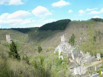
• Symbol: Blaues Oval auf grünem Oval auf gelben Grund. Grüner Text Vulkaneifel-Pfad. Blauer Text Manderschieder Burgen...
![Tour Zu Fuß Minheim - Minheimer Wald - Photo](https://media.geolcdn.com/t/350/260/6b8b8df9-9d1f-40c8-b4ec-90ae477e67d6.jpeg&format=jpg&maxdim=2)
![Zu Fuß Zu Fuß](https://static1.geolcdn.com/sitytour/trail-icons/100.png)
Km
Zu Fuß
![](/images/other/stat-length.png)
![](https://static1.geolcdn.com/siteimages/upload/files/1508320355ic_sort_den_pos_24dp.png)
![](https://static1.geolcdn.com/siteimages/upload/files/1508320355ic_sort_den_neg_24dp.png)
![](https://static1.geolcdn.com/siteimages/upload/files/16400158638029165_repeat_loop_refresh_sync_direction_icon.png)
• Trail created by Ortsgemeinde Minheim.
![Tour Zu Fuß Reil - Alftalhöhenweg - Photo](https://media.geolcdn.com/t/350/260/ba5d4de8-2450-49d0-a88f-95a8b5e3c72c.jpeg&format=jpg&maxdim=2)
![Zu Fuß Zu Fuß](https://static1.geolcdn.com/sitytour/trail-icons/100.png)
Km
Zu Fuß
![](/images/other/stat-length.png)
![](https://static1.geolcdn.com/siteimages/upload/files/1508320355ic_sort_den_pos_24dp.png)
![](https://static1.geolcdn.com/siteimages/upload/files/1508320355ic_sort_den_neg_24dp.png)
![](https://static1.geolcdn.com/siteimages/upload/files/16400158638029165_repeat_loop_refresh_sync_direction_icon.png)
• Symbol: black A on white background
![Tour Zu Fuß Minheim - Weinerlebnispfad Minheim - Photo](https://media.geolcdn.com/t/350/260/9ce3b244-b610-41d8-a3df-2bfab6f536db.jpeg&format=jpg&maxdim=2)
![Zu Fuß Zu Fuß](https://static1.geolcdn.com/sitytour/trail-icons/100.png)
Km
Zu Fuß
![](/images/other/stat-length.png)
![](https://static1.geolcdn.com/siteimages/upload/files/1508320355ic_sort_den_pos_24dp.png)
![](https://static1.geolcdn.com/siteimages/upload/files/1508320355ic_sort_den_neg_24dp.png)
![](https://static1.geolcdn.com/siteimages/upload/files/16400158638029165_repeat_loop_refresh_sync_direction_icon.png)
• Trail created by Ortsgemeinde Minheim.
![Tour Zu Fuß Dreis - Orchideenweg - Photo](https://media.geolcdn.com/t/350/260/5c493ee6-0f99-4b0c-8248-51629e87d174.jpeg&format=jpg&maxdim=2)
![Zu Fuß Zu Fuß](https://static1.geolcdn.com/sitytour/trail-icons/100.png)
Km
Zu Fuß
![](/images/other/stat-length.png)
![](https://static1.geolcdn.com/siteimages/upload/files/1508320355ic_sort_den_pos_24dp.png)
![](https://static1.geolcdn.com/siteimages/upload/files/1508320355ic_sort_den_neg_24dp.png)
![](https://static1.geolcdn.com/siteimages/upload/files/16400158638029165_repeat_loop_refresh_sync_direction_icon.png)
• Symbol: rote Orchidee mit grünen Blättern auf weißem Grund Website: http://www.og-dreis.de/index.php?section=Naturp...
![Tour Zu Fuß Wittlich - Wittlich 10 - Photo](https://media.geolcdn.com/t/350/260/7b823201-2113-48da-8fd8-de70a6b5f976.jpeg&format=jpg&maxdim=2)
![Zu Fuß Zu Fuß](https://static1.geolcdn.com/sitytour/trail-icons/100.png)
Km
Zu Fuß
![](/images/other/stat-length.png)
![](https://static1.geolcdn.com/siteimages/upload/files/1508320355ic_sort_den_pos_24dp.png)
![](https://static1.geolcdn.com/siteimages/upload/files/1508320355ic_sort_den_neg_24dp.png)
![](https://static1.geolcdn.com/siteimages/upload/files/16400158638029165_repeat_loop_refresh_sync_direction_icon.png)
• Trail created by Eifelverein.
![Tour Zu Fuß Wittlich - Wittlich 8 - Photo](https://media.geolcdn.com/t/350/260/902e368d-d1be-4d29-8677-3181f79b2da7.jpeg&format=jpg&maxdim=2)
![Zu Fuß Zu Fuß](https://static1.geolcdn.com/sitytour/trail-icons/100.png)
Km
Zu Fuß
![](/images/other/stat-length.png)
![](https://static1.geolcdn.com/siteimages/upload/files/1508320355ic_sort_den_pos_24dp.png)
![](https://static1.geolcdn.com/siteimages/upload/files/1508320355ic_sort_den_neg_24dp.png)
![](https://static1.geolcdn.com/siteimages/upload/files/16400158638029165_repeat_loop_refresh_sync_direction_icon.png)
• Trail created by Eifelverein.
20 Angezeigte Touren bei 114
Kostenlosegpshiking-Anwendung
Aktivitäten
Nahegelegene Regionen
- Arenrath
- Bergweiler
- Bernkastel-Kues
- Bettenfeld
- Brauneberg
- Bruch
- Dreis
- Eckfeld
- Enkirch
- Erden
- Flußbach
- Gladbach
- Graach an der Mosel
- Gräfendhron
- Großlittgen
- Hasborn
- Heckenmünster
- Heidenburg
- Hetzerath
- Hilscheid
- Hontheim
- Horath
- Hupperath
- Karl
- Kesten
- Kinheim
- Kommen
- Kröv
- Landscheid
- Laufeld
- Lieser
- Longkamp
- Lösnich
- Manderscheid
- Maring-Noviand
- Meerfeld
- Minheim
- Monzelfeld
- Morbach
- Mülheim an der Mosel
- Musweiler
- Neumagen-Dhron
- Niederscheidweiler
- Niersbach
- Oberöfflingen
- Oberscheidweiler
- Osann-Monzel
- Pantenburg
- Piesport
- Platten
- Reil
- Schwarzenborn
- Sehlem
- Thalfang
- Traben-Trarbach
- Ürzig
- Veldenz
- Wallscheid
- Wintrich
- Wittlich
- Zeltingen-Rachtig