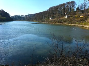
![](/images/other/stat-length.png)
- Touren
- Outdoor
- Germany
- Nordrhein-Westfalen
- Leverkusen
- Unbekannt
- Stadtbezirk II
Stadtbezirk II, Unbekannt: Die besten Touren, Trails, Trecks und Wanderungen
Stadtbezirk II : Entdecken Sie die besten Touren : 8 zu Fuß. Alle diese Touren, Trails, Routen und Outdoor-Aktivitäten sind in unseren SityTrail-Apps für Smartphones und Tablets verfügbar.
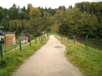
Die besten Spuren (8)
![Tour Zu Fuß Unbekannt - Bergisch-Neukirchen Rundweg A8 - Photo](https://media.geolcdn.com/t/350/260/1c9f756c-9f0a-4258-a5eb-501dc87f2896.jpeg&format=jpg&maxdim=2)
![Zu Fuß Zu Fuß](https://static1.geolcdn.com/sitytour/trail-icons/100.png)
Km
Zu Fuß
![](/images/other/stat-length.png)
![](https://static1.geolcdn.com/siteimages/upload/files/1508320355ic_sort_den_pos_24dp.png)
![](https://static1.geolcdn.com/siteimages/upload/files/1508320355ic_sort_den_neg_24dp.png)
![](https://static1.geolcdn.com/siteimages/upload/files/16400158638029165_repeat_loop_refresh_sync_direction_icon.png)
• Trail created by Sauerländischer Gebirgsverein. Symbol: A8
![Tour Zu Fuß Unbekannt - Bergisch-Neukirchen Rundweg A7 - Photo](https://media.geolcdn.com/t/350/260/fdc265b1-c0df-4597-80be-c7603647c272.jpeg&format=jpg&maxdim=2)
![Zu Fuß Zu Fuß](https://static1.geolcdn.com/sitytour/trail-icons/100.png)
Km
Zu Fuß
![](/images/other/stat-length.png)
![](https://static1.geolcdn.com/siteimages/upload/files/1508320355ic_sort_den_pos_24dp.png)
![](https://static1.geolcdn.com/siteimages/upload/files/1508320355ic_sort_den_neg_24dp.png)
![](https://static1.geolcdn.com/siteimages/upload/files/16400158638029165_repeat_loop_refresh_sync_direction_icon.png)
• Trail created by Sauerländischer Gebirgsverein. Symbol: weißes A7 auf schwarzem Grund
![Tour Zu Fuß Unbekannt - Obstweg Leverkusen - Photo](https://media.geolcdn.com/t/350/260/46f237d9-b111-4e3d-a3b2-45f68d5a6a13.jpeg&format=jpg&maxdim=2)
![Zu Fuß Zu Fuß](https://static1.geolcdn.com/sitytour/trail-icons/100.png)
Km
Zu Fuß
![](/images/other/stat-length.png)
![](https://static1.geolcdn.com/siteimages/upload/files/1508320355ic_sort_den_pos_24dp.png)
![](https://static1.geolcdn.com/siteimages/upload/files/1508320355ic_sort_den_neg_24dp.png)
![](https://static1.geolcdn.com/siteimages/upload/files/16400158638029165_repeat_loop_refresh_sync_direction_icon.png)
• Trail created by NABU-Naturschutzstaion Rhein-Berg. Führt ausgehend vom NaturGut Ophoven in Leverkusen-Opladen durch...
![Tour Zu Fuß Unbekannt - Naturfreundeweg Neuenkamp - Rath/Heumar - Photo](https://media.geolcdn.com/t/350/260/ext.jpg?maxdim=2&url=https%3A%2F%2Fupload.wikimedia.org%2Fwikipedia%2Fcommons%2Fthumb%2F6%2F68%2FAston_Martin_SP10_Roadster.jpg%2F2000px-Aston_Martin_SP10_Roadster.jpg)
![Zu Fuß Zu Fuß](https://static1.geolcdn.com/sitytour/trail-icons/100.png)
Km
Zu Fuß
![](/images/other/stat-length.png)
![](https://static1.geolcdn.com/siteimages/upload/files/1508320355ic_sort_den_pos_24dp.png)
![](https://static1.geolcdn.com/siteimages/upload/files/1508320355ic_sort_den_neg_24dp.png)
![](https://static1.geolcdn.com/siteimages/upload/files/16400158638029165_repeat_loop_refresh_sync_direction_icon.png)
• Symbol: N
![Tour Zu Fuß Unbekannt - Bergisch-Neukirchen Rundweg A1 - Photo](https://media.geolcdn.com/t/350/260/7c80817f-8afe-4746-9dfe-41f5b18539cf.jpeg&format=jpg&maxdim=2)
![Zu Fuß Zu Fuß](https://static1.geolcdn.com/sitytour/trail-icons/100.png)
Km
Zu Fuß
![](/images/other/stat-length.png)
![](https://static1.geolcdn.com/siteimages/upload/files/1508320355ic_sort_den_pos_24dp.png)
![](https://static1.geolcdn.com/siteimages/upload/files/1508320355ic_sort_den_neg_24dp.png)
![](https://static1.geolcdn.com/siteimages/upload/files/16400158638029165_repeat_loop_refresh_sync_direction_icon.png)
• Trail created by VVV Bergisch-Neukirchen e.V.. Symbol: A1
![Tour Zu Fuß Unbekannt - (BN) Rund um Bergisch-Neukirchen - Photo](https://media.geolcdn.com/t/350/260/75a5e3e8-3fd2-4666-a613-a383730390fe.jpeg&format=jpg&maxdim=2)
![Zu Fuß Zu Fuß](https://static1.geolcdn.com/sitytour/trail-icons/100.png)
Km
Zu Fuß
![](/images/other/stat-length.png)
![](https://static1.geolcdn.com/siteimages/upload/files/1508320355ic_sort_den_pos_24dp.png)
![](https://static1.geolcdn.com/siteimages/upload/files/1508320355ic_sort_den_neg_24dp.png)
![](https://static1.geolcdn.com/siteimages/upload/files/16400158638029165_repeat_loop_refresh_sync_direction_icon.png)
• Trail created by VVV Bergisch-Neukirchen e.V.. Symbol: "BN" im Kreis
![Tour Zu Fuß Unbekannt - Bergisch-Neukirchen Rundweg A6 - Photo](https://media.geolcdn.com/t/350/260/231986fc-9359-4d41-86ac-916d8c843dc3.jpeg&format=jpg&maxdim=2)
![Zu Fuß Zu Fuß](https://static1.geolcdn.com/sitytour/trail-icons/100.png)
Km
Zu Fuß
![](/images/other/stat-length.png)
![](https://static1.geolcdn.com/siteimages/upload/files/1508320355ic_sort_den_pos_24dp.png)
![](https://static1.geolcdn.com/siteimages/upload/files/1508320355ic_sort_den_neg_24dp.png)
![](https://static1.geolcdn.com/siteimages/upload/files/16400158638029165_repeat_loop_refresh_sync_direction_icon.png)
• Trail created by VVV Bergisch-Neukirchen e.V.. Symbol: weißes A6 auf schwarzem Grund
![Tour Zu Fuß Unbekannt - Bergisch-Neukirchen Rundweg A5 - Photo](https://media.geolcdn.com/t/350/260/75a5e3e8-3fd2-4666-a613-a383730390fe.jpeg&format=jpg&maxdim=2)
![Zu Fuß Zu Fuß](https://static1.geolcdn.com/sitytour/trail-icons/100.png)
Km
Zu Fuß
![](/images/other/stat-length.png)
![](https://static1.geolcdn.com/siteimages/upload/files/1508320355ic_sort_den_pos_24dp.png)
![](https://static1.geolcdn.com/siteimages/upload/files/1508320355ic_sort_den_neg_24dp.png)
![](https://static1.geolcdn.com/siteimages/upload/files/16400158638029165_repeat_loop_refresh_sync_direction_icon.png)
• Trail created by VVV Bergisch-Neukirchen e.V..
8 Angezeigte Touren bei 8
Kostenlosegpshiking-Anwendung