![](/images/other/stat-length.png)
Bautzen, Sachsen: Die besten Touren, Trails, Trecks und Wanderungen
Bautzen : Entdecken Sie die besten Touren : 77 zu Fuß. Alle diese Touren, Trails, Routen und Outdoor-Aktivitäten sind in unseren SityTrail-Apps für Smartphones und Tablets verfügbar.
Die besten Spuren (77)
![Tour Zu Fuß Sohland a. d. Spree - CZ-This is originaly german learning path, not czech. It has german and czech text on the infotables. - Photo](https://media.geolcdn.com/t/350/260/ca963332-302c-4d27-8da8-131868543ed8.jpeg&format=jpg&maxdim=2)
![Zu Fuß Zu Fuß](https://static1.geolcdn.com/sitytour/trail-icons/100.png)
Km
Zu Fuß
![](/images/other/stat-length.png)
![](https://static1.geolcdn.com/siteimages/upload/files/1508320355ic_sort_den_pos_24dp.png)
![](https://static1.geolcdn.com/siteimages/upload/files/1508320355ic_sort_den_neg_24dp.png)
![](https://static1.geolcdn.com/siteimages/upload/files/16400158638029165_repeat_loop_refresh_sync_direction_icon.png)
• This is originaly german learning path, not czech. It has german and czech text on the infotables.
![Tour Zu Fuß Königswartha - Neschwitz - Caminau - Photo](https://media.geolcdn.com/t/350/260/273d7cc7-8997-409b-8299-5349c6f5894f.jpeg&format=jpg&maxdim=2)
![Zu Fuß Zu Fuß](https://static1.geolcdn.com/sitytour/trail-icons/100.png)
Km
Zu Fuß
![](/images/other/stat-length.png)
![](https://static1.geolcdn.com/siteimages/upload/files/1508320355ic_sort_den_pos_24dp.png)
![](https://static1.geolcdn.com/siteimages/upload/files/1508320355ic_sort_den_neg_24dp.png)
![](https://static1.geolcdn.com/siteimages/upload/files/16400158638029165_repeat_loop_refresh_sync_direction_icon.png)
• Symbol: Grüner Punkt auf weißem Grund
![Tour Zu Fuß Neschwitz - SZ-Rundwanderweg - Photo](https://media.geolcdn.com/t/350/260/d8996110-993b-4088-a1de-6a9026c15b17.jpeg&format=jpg&maxdim=2)
![Zu Fuß Zu Fuß](https://static1.geolcdn.com/sitytour/trail-icons/100.png)
Km
Zu Fuß
![](/images/other/stat-length.png)
![](https://static1.geolcdn.com/siteimages/upload/files/1508320355ic_sort_den_pos_24dp.png)
![](https://static1.geolcdn.com/siteimages/upload/files/1508320355ic_sort_den_neg_24dp.png)
![](https://static1.geolcdn.com/siteimages/upload/files/16400158638029165_repeat_loop_refresh_sync_direction_icon.png)
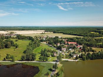
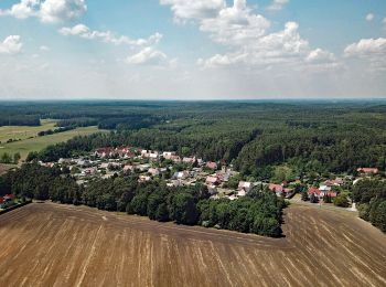
• Mit der Familie die Heide- und Teichlandschaft der Oberlausitz entdecken. Website: https://www.saechsische.de/wander...
![Tour Zu Fuß Schwepnitz - Energie-Entdeckerpfad - Photo](https://media.geolcdn.com/t/350/260/779f7def-1c38-4444-afea-78601edc7937.jpeg&format=jpg&maxdim=2)
![Zu Fuß Zu Fuß](https://static1.geolcdn.com/sitytour/trail-icons/100.png)
Km
Zu Fuß
![](/images/other/stat-length.png)
![](https://static1.geolcdn.com/siteimages/upload/files/1508320355ic_sort_den_pos_24dp.png)
![](https://static1.geolcdn.com/siteimages/upload/files/1508320355ic_sort_den_neg_24dp.png)
![](https://static1.geolcdn.com/siteimages/upload/files/16400158638029165_repeat_loop_refresh_sync_direction_icon.png)
• Route entspricht nicht der Darstellung auf den Infotafeln, da diese teils nicht der Realität entsprechen
![Tour Zu Fuß Cunewalde - Köblitzer Rundweg - Photo](https://media.geolcdn.com/t/350/260/dca177b9-0760-48e4-bc2d-aa1be21efab0.jpeg&format=jpg&maxdim=2)
![Zu Fuß Zu Fuß](https://static1.geolcdn.com/sitytour/trail-icons/100.png)
Km
Zu Fuß
![](/images/other/stat-length.png)
![](https://static1.geolcdn.com/siteimages/upload/files/1508320355ic_sort_den_pos_24dp.png)
![](https://static1.geolcdn.com/siteimages/upload/files/1508320355ic_sort_den_neg_24dp.png)
![](https://static1.geolcdn.com/siteimages/upload/files/16400158638029165_repeat_loop_refresh_sync_direction_icon.png)
• Symbol: grünes Dreieck auf weißen Untergrund
![Tour Zu Fuß Malschwitz - Naturerlebnispfad „Guttauer Teiche & Olbasee](https://media.geolcdn.com/t/350/260/8d7388bd-5f51-4bd2-b123-0b0f9b321665.jpeg&format=jpg&maxdim=2)
![Zu Fuß Zu Fuß](https://static1.geolcdn.com/sitytour/trail-icons/100.png)
Km
Zu Fuß
![](/images/other/stat-length.png)
![](https://static1.geolcdn.com/siteimages/upload/files/1508320355ic_sort_den_pos_24dp.png)
![](https://static1.geolcdn.com/siteimages/upload/files/1508320355ic_sort_den_neg_24dp.png)
![](https://static1.geolcdn.com/siteimages/upload/files/16400158638029165_repeat_loop_refresh_sync_direction_icon.png)
• Symbol: gelber Schrägstrich (/) auf weißem Grund Website: https://www.biosphaerenreservat-oberlausitz.de/de/naturer...
![Tour Zu Fuß Malschwitz - Naturerlebnispfad „Guttauer Teiche & Olbasee](https://media.geolcdn.com/t/350/260/8c3b158e-eb5a-4e41-aff9-a896229a4f34.jpeg&format=jpg&maxdim=2)
![Zu Fuß Zu Fuß](https://static1.geolcdn.com/sitytour/trail-icons/100.png)
Km
Zu Fuß
![](/images/other/stat-length.png)
![](https://static1.geolcdn.com/siteimages/upload/files/1508320355ic_sort_den_pos_24dp.png)
![](https://static1.geolcdn.com/siteimages/upload/files/1508320355ic_sort_den_neg_24dp.png)
![](https://static1.geolcdn.com/siteimages/upload/files/16400158638029165_repeat_loop_refresh_sync_direction_icon.png)
• Symbol: gelber Schrägstrich (/) auf weißem Grund Website: https://www.biosphaerenreservat-oberlausitz.de/de/naturer...
![Tour Zu Fuß Panschwitz-Kuckau - Rundwanderweg Grüner Punkt Ostroer Schanze - Photo](https://media.geolcdn.com/t/350/260/eeebd681-b8b5-4127-8c5d-6b8b0cfbd25d.jpeg&format=jpg&maxdim=2)
![Zu Fuß Zu Fuß](https://static1.geolcdn.com/sitytour/trail-icons/100.png)
Km
Zu Fuß
![](/images/other/stat-length.png)
![](https://static1.geolcdn.com/siteimages/upload/files/1508320355ic_sort_den_pos_24dp.png)
![](https://static1.geolcdn.com/siteimages/upload/files/1508320355ic_sort_den_neg_24dp.png)
![](https://static1.geolcdn.com/siteimages/upload/files/16400158638029165_repeat_loop_refresh_sync_direction_icon.png)
• Symbol: Grüner Punkt auf weißem Grund
![Tour Zu Fuß Elstra - Grüner Punkt Rundwanderweg Elstra - Leipsberg - Photo](https://media.geolcdn.com/t/350/260/09a9af4f-1e54-491d-bdf5-e43e18db4f6d.jpeg&format=jpg&maxdim=2)
![Zu Fuß Zu Fuß](https://static1.geolcdn.com/sitytour/trail-icons/100.png)
Km
Zu Fuß
![](/images/other/stat-length.png)
![](https://static1.geolcdn.com/siteimages/upload/files/1508320355ic_sort_den_pos_24dp.png)
![](https://static1.geolcdn.com/siteimages/upload/files/1508320355ic_sort_den_neg_24dp.png)
![](https://static1.geolcdn.com/siteimages/upload/files/16400158638029165_repeat_loop_refresh_sync_direction_icon.png)
• Symbol: Grüner Punkt auf weißem Grund
![Tour Zu Fuß Neschwitz - Unkenpfad Wanderweg - Photo](https://media.geolcdn.com/t/350/260/650796d9-16eb-4b05-b18a-6a048e7195af.jpeg&format=jpg&maxdim=2)
![Zu Fuß Zu Fuß](https://static1.geolcdn.com/sitytour/trail-icons/100.png)
Km
Zu Fuß
![](/images/other/stat-length.png)
![](https://static1.geolcdn.com/siteimages/upload/files/1508320355ic_sort_den_pos_24dp.png)
![](https://static1.geolcdn.com/siteimages/upload/files/1508320355ic_sort_den_neg_24dp.png)
![](https://static1.geolcdn.com/siteimages/upload/files/16400158638029165_repeat_loop_refresh_sync_direction_icon.png)
• Symbol: Rotbauchunke
![Tour Zu Fuß Kamenz - Rundweg Großteich Deutschbaselitz - Photo](https://media.geolcdn.com/t/350/260/7a2bccb1-790f-4375-9d8b-e1bd1dadfcd6.jpeg&format=jpg&maxdim=2)
![Zu Fuß Zu Fuß](https://static1.geolcdn.com/sitytour/trail-icons/100.png)
Km
Zu Fuß
![](/images/other/stat-length.png)
![](https://static1.geolcdn.com/siteimages/upload/files/1508320355ic_sort_den_pos_24dp.png)
![](https://static1.geolcdn.com/siteimages/upload/files/1508320355ic_sort_den_neg_24dp.png)
![](https://static1.geolcdn.com/siteimages/upload/files/16400158638029165_repeat_loop_refresh_sync_direction_icon.png)
• Symbol: Gelber Balken und Grüner Balken auf weißem Hintergrund
![Tour Zu Fuß Neschwitz - Naturlehrpfad Caßlauer Wiesenteiche - Photo](https://media.geolcdn.com/t/350/260/ad0e7629-676d-462c-af93-a9ca3065664d.jpeg&format=jpg&maxdim=2)
![Zu Fuß Zu Fuß](https://static1.geolcdn.com/sitytour/trail-icons/100.png)
Km
Zu Fuß
![](/images/other/stat-length.png)
![](https://static1.geolcdn.com/siteimages/upload/files/1508320355ic_sort_den_pos_24dp.png)
![](https://static1.geolcdn.com/siteimages/upload/files/1508320355ic_sort_den_neg_24dp.png)
![](https://static1.geolcdn.com/siteimages/upload/files/16400158638029165_repeat_loop_refresh_sync_direction_icon.png)
• Symbol: Pfeilkraut Pflanze auf kleinem grünen Schild
![Tour Zu Fuß Lohsa - Rundweg durch Steinitz und Weißig - Photo](https://media.geolcdn.com/t/350/260/542eff84-36bb-48c0-9b1d-2d28c6a8b70a.jpeg&format=jpg&maxdim=2)
![Zu Fuß Zu Fuß](https://static1.geolcdn.com/sitytour/trail-icons/100.png)
Km
Zu Fuß
![](/images/other/stat-length.png)
![](https://static1.geolcdn.com/siteimages/upload/files/1508320355ic_sort_den_pos_24dp.png)
![](https://static1.geolcdn.com/siteimages/upload/files/1508320355ic_sort_den_neg_24dp.png)
![](https://static1.geolcdn.com/siteimages/upload/files/16400158638029165_repeat_loop_refresh_sync_direction_icon.png)
• Symbol: Gelber Punkt auf weißem Grund
![Tour Zu Fuß Rammenau - schwarze Rammenauer Rundwanderung - Photo](https://media.geolcdn.com/t/350/260/ec6731e4-461f-4206-b55e-31ac68414437.jpeg&format=jpg&maxdim=2)
![Zu Fuß Zu Fuß](https://static1.geolcdn.com/sitytour/trail-icons/100.png)
Km
Zu Fuß
![](/images/other/stat-length.png)
![](https://static1.geolcdn.com/siteimages/upload/files/1508320355ic_sort_den_pos_24dp.png)
![](https://static1.geolcdn.com/siteimages/upload/files/1508320355ic_sort_den_neg_24dp.png)
![](https://static1.geolcdn.com/siteimages/upload/files/16400158638029165_repeat_loop_refresh_sync_direction_icon.png)
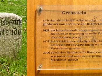
• Trail created by Gemeinde Rammenau. Symbol: schwarzer Bindestrich
![Tour Zu Fuß Steina - Gersdorf - Schwedenstein - Photo](https://media.geolcdn.com/t/350/260/17e185c4-9da2-4ee7-9d1e-e51e2dce703f.jpeg&format=jpg&maxdim=2)
![Zu Fuß Zu Fuß](https://static1.geolcdn.com/sitytour/trail-icons/100.png)
Km
Zu Fuß
![](/images/other/stat-length.png)
![](https://static1.geolcdn.com/siteimages/upload/files/1508320355ic_sort_den_pos_24dp.png)
![](https://static1.geolcdn.com/siteimages/upload/files/1508320355ic_sort_den_neg_24dp.png)
![](https://static1.geolcdn.com/siteimages/upload/files/16400158638029165_repeat_loop_refresh_sync_direction_icon.png)
• Symbol: Grüner Strich auf weißem Grund
![Tour Zu Fuß Kamenz - Grüner Balken Großteich - Photo](https://media.geolcdn.com/t/350/260/03bb37e9-4b47-49f2-b15e-1dd93d632a50.jpeg&format=jpg&maxdim=2)
![Zu Fuß Zu Fuß](https://static1.geolcdn.com/sitytour/trail-icons/100.png)
Km
Zu Fuß
![](/images/other/stat-length.png)
![](https://static1.geolcdn.com/siteimages/upload/files/1508320355ic_sort_den_pos_24dp.png)
![](https://static1.geolcdn.com/siteimages/upload/files/1508320355ic_sort_den_neg_24dp.png)
![](https://static1.geolcdn.com/siteimages/upload/files/16400158638029165_repeat_loop_refresh_sync_direction_icon.png)
• Symbol: green bar
![Tour Zu Fuß Kamenz - Gelber Punkt Sandteichrundweg - Photo](https://media.geolcdn.com/t/350/260/d1e08cc8-9583-4a32-bca8-9c04eb72c451.jpeg&format=jpg&maxdim=2)
![Zu Fuß Zu Fuß](https://static1.geolcdn.com/sitytour/trail-icons/100.png)
Km
Zu Fuß
![](/images/other/stat-length.png)
![](https://static1.geolcdn.com/siteimages/upload/files/1508320355ic_sort_den_pos_24dp.png)
![](https://static1.geolcdn.com/siteimages/upload/files/1508320355ic_sort_den_neg_24dp.png)
![](https://static1.geolcdn.com/siteimages/upload/files/16400158638029165_repeat_loop_refresh_sync_direction_icon.png)
• Symbol: Gelber Punkt auf weißem Hintergrund
![Tour Zu Fuß Kamenz - Weißiger Teiche - Deutschbaselitz - Photo](https://media.geolcdn.com/t/350/260/7a2bccb1-790f-4375-9d8b-e1bd1dadfcd6.jpeg&format=jpg&maxdim=2)
![Zu Fuß Zu Fuß](https://static1.geolcdn.com/sitytour/trail-icons/100.png)
Km
Zu Fuß
![](/images/other/stat-length.png)
![](https://static1.geolcdn.com/siteimages/upload/files/1508320355ic_sort_den_pos_24dp.png)
![](https://static1.geolcdn.com/siteimages/upload/files/1508320355ic_sort_den_neg_24dp.png)
![](https://static1.geolcdn.com/siteimages/upload/files/16400158638029165_repeat_loop_refresh_sync_direction_icon.png)
• Symbol: Gelber Balken auf weißem Hintergrund
![Tour Zu Fuß Lauta - Rundweg um Lauta - Gelber Punkt - Photo](https://media.geolcdn.com/t/350/260/1006afbd-d06b-408a-82e6-5702db99f04b.jpeg&format=jpg&maxdim=2)
![Zu Fuß Zu Fuß](https://static1.geolcdn.com/sitytour/trail-icons/100.png)
Km
Zu Fuß
![](/images/other/stat-length.png)
![](https://static1.geolcdn.com/siteimages/upload/files/1508320355ic_sort_den_pos_24dp.png)
![](https://static1.geolcdn.com/siteimages/upload/files/1508320355ic_sort_den_neg_24dp.png)
![](https://static1.geolcdn.com/siteimages/upload/files/16400158638029165_repeat_loop_refresh_sync_direction_icon.png)
• Ausschilderung zwischen Lauta und Laubush fehlt Symbol: Gelber Punkt auf weißem Hintergrund
![Tour Zu Fuß Rammenau - violette Rammenauer Rundwanderung - Photo](https://media.geolcdn.com/t/350/260/b9fcdc66-41e4-463e-8dd8-b1370b025813.jpeg&format=jpg&maxdim=2)
![Zu Fuß Zu Fuß](https://static1.geolcdn.com/sitytour/trail-icons/100.png)
Km
Zu Fuß
![](/images/other/stat-length.png)
![](https://static1.geolcdn.com/siteimages/upload/files/1508320355ic_sort_den_pos_24dp.png)
![](https://static1.geolcdn.com/siteimages/upload/files/1508320355ic_sort_den_neg_24dp.png)
![](https://static1.geolcdn.com/siteimages/upload/files/16400158638029165_repeat_loop_refresh_sync_direction_icon.png)
• Symbol im Test
20 Angezeigte Touren bei 77
Kostenlosegpshiking-Anwendung
Aktivitäten
Nahegelegene Regionen
- Arnsdorf
- Bautzen
- Bernsdorf
- Bischofswerda
- Cunewalde
- Doberschau-Gaußig
- Elstra
- Großdubrau
- Großharthau
- Großröhrsdorf
- Haselbachtal
- Hoyerswerda
- Kamenz
- Königsbrück
- Königswartha
- Kubschütz
- Lauta
- Laußnitz
- Lichtenberg
- Lohsa
- Malschwitz
- Neschwitz
- Neukirch
- Neukirch/Lausitz
- Obergurig
- Ohorn
- Ottendorf-Okrilla
- Panschwitz-Kuckau
- Pulsnitz
- Radeberg
- Rammenau
- Schwepnitz
- Sohland a. d. Spree
- Steina
- Steinigtwolmsdorf
- Wachau
- Weißenberg
- Wilthen