![](/images/other/stat-length.png)
Trentschiner Landschaftsverband, Slovakia, Zu Fuß: Die besten Touren, Trails, Trecks und Wanderungen
Trentschiner Landschaftsverband : Entdecken Sie die besten Touren : 45 zu fuß und 1 laufen. Alle diese Touren, Trails, Routen und Outdoor-Aktivitäten sind in unseren SityTrail-Apps für Smartphones und Tablets verfügbar.
Die besten Spuren (46)
![Tour Zu Fuß Bezirk Neustadt an der Waag - Náučný chodník Brestovec - Stará Myjava - Topolecká - Photo](https://media.geolcdn.com/t/350/260/0f1a443f-2206-4c7f-8559-a63027eb9211.jpeg&format=jpg&maxdim=2)
![Zu Fuß Zu Fuß](https://static1.geolcdn.com/sitytour/trail-icons/100.png)
Km
Zu Fuß
![](/images/other/stat-length.png)
![](https://static1.geolcdn.com/siteimages/upload/files/1508320355ic_sort_den_pos_24dp.png)
![](https://static1.geolcdn.com/siteimages/upload/files/1508320355ic_sort_den_neg_24dp.png)
![](https://static1.geolcdn.com/siteimages/upload/files/16400158638029165_repeat_loop_refresh_sync_direction_icon.png)
• Symbol: education
![Tour Zu Fuß Bezirk Trentschin - Jastrabská](https://media.geolcdn.com/t/350/260/f5d2ba1c-1e38-4c67-a22d-c29bd6bc1e9a.jpeg&format=jpg&maxdim=2)
![Zu Fuß Zu Fuß](https://static1.geolcdn.com/sitytour/trail-icons/100.png)
Km
Zu Fuß
![](/images/other/stat-length.png)
![](https://static1.geolcdn.com/siteimages/upload/files/1508320355ic_sort_den_pos_24dp.png)
![](https://static1.geolcdn.com/siteimages/upload/files/1508320355ic_sort_den_neg_24dp.png)
![](https://static1.geolcdn.com/siteimages/upload/files/16400158638029165_repeat_loop_refresh_sync_direction_icon.png)
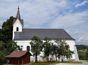
• Tour erstellt von Obec Trenčianske Jastrabie. Symbol: white:black
![Tour Zu Fuß Bezirk Trentschin - IVV6 - VLADOV CHODNÍK (maratónska trasa) - Photo](https://media.geolcdn.com/t/350/260/6431251b-aa09-4a8f-af79-8add328de865.jpeg&format=jpg&maxdim=2)
![Zu Fuß Zu Fuß](https://static1.geolcdn.com/sitytour/trail-icons/100.png)
Km
Zu Fuß
![](/images/other/stat-length.png)
![](https://static1.geolcdn.com/siteimages/upload/files/1508320355ic_sort_den_pos_24dp.png)
![](https://static1.geolcdn.com/siteimages/upload/files/1508320355ic_sort_den_neg_24dp.png)
![](https://static1.geolcdn.com/siteimages/upload/files/16400158638029165_repeat_loop_refresh_sync_direction_icon.png)
• Tour erstellt von KST. Symbol: none
![Tour Zu Fuß Bezirk Trentschin - Náučný chodník Putovanie za živou vodou - Photo](https://media.geolcdn.com/t/350/260/ac746b1f-6dc8-4b61-94b6-b4ce8051929e.jpeg&format=jpg&maxdim=2)
![Zu Fuß Zu Fuß](https://static1.geolcdn.com/sitytour/trail-icons/100.png)
Km
Zu Fuß
![](/images/other/stat-length.png)
![](https://static1.geolcdn.com/siteimages/upload/files/1508320355ic_sort_den_pos_24dp.png)
![](https://static1.geolcdn.com/siteimages/upload/files/1508320355ic_sort_den_neg_24dp.png)
![](https://static1.geolcdn.com/siteimages/upload/files/16400158638029165_repeat_loop_refresh_sync_direction_icon.png)
• Symbol: none
![Tour Zu Fuß okres Považská Bystrica - SK-Local marking made by village Slopna. There are guidepost with defined color for paths, but without physical marking. There are no guideposts outside the Slopna territory even if the path is ending elsewhere. - Photo](https://media.geolcdn.com/t/350/260/c7c1c3c4-4fca-4c0a-906b-a25ff26e4233.jpeg&format=jpg&maxdim=2)
![Zu Fuß Zu Fuß](https://static1.geolcdn.com/sitytour/trail-icons/100.png)
Km
Zu Fuß
![](/images/other/stat-length.png)
![](https://static1.geolcdn.com/siteimages/upload/files/1508320355ic_sort_den_pos_24dp.png)
![](https://static1.geolcdn.com/siteimages/upload/files/1508320355ic_sort_den_neg_24dp.png)
![](https://static1.geolcdn.com/siteimages/upload/files/16400158638029165_repeat_loop_refresh_sync_direction_icon.png)
• Tour erstellt von Obec Slopná. Local marking made by village Slopna. There are guidepost with defined color for path...
![Tour Zu Fuß Bezirk Trentschin - IVV5 - JANOV CHODNÍK (dlhá rodinná trasa) - Photo](https://media.geolcdn.com/t/350/260/4b9f1942-e6b0-405b-a1d0-c332aba9276a.jpeg&format=jpg&maxdim=2)
![Zu Fuß Zu Fuß](https://static1.geolcdn.com/sitytour/trail-icons/100.png)
Km
Zu Fuß
![](/images/other/stat-length.png)
![](https://static1.geolcdn.com/siteimages/upload/files/1508320355ic_sort_den_pos_24dp.png)
![](https://static1.geolcdn.com/siteimages/upload/files/1508320355ic_sort_den_neg_24dp.png)
![](https://static1.geolcdn.com/siteimages/upload/files/16400158638029165_repeat_loop_refresh_sync_direction_icon.png)
• Tour erstellt von KST. Symbol: none
![Tour Zu Fuß Bezirk Trentschin - IVV4 - ANKIN CHODNÍK (stredná rodinná trasa) - Photo](https://media.geolcdn.com/t/350/260/4b9f1942-e6b0-405b-a1d0-c332aba9276a.jpeg&format=jpg&maxdim=2)
![Zu Fuß Zu Fuß](https://static1.geolcdn.com/sitytour/trail-icons/100.png)
Km
Zu Fuß
![](/images/other/stat-length.png)
![](https://static1.geolcdn.com/siteimages/upload/files/1508320355ic_sort_den_pos_24dp.png)
![](https://static1.geolcdn.com/siteimages/upload/files/1508320355ic_sort_den_neg_24dp.png)
![](https://static1.geolcdn.com/siteimages/upload/files/16400158638029165_repeat_loop_refresh_sync_direction_icon.png)
• Tour erstellt von KST. Symbol: none
![Tour Zu Fuß Bezirk Trentschin - IVV3 - STANOV CHODNÍK (krátka rodinná trasa) - Photo](https://media.geolcdn.com/t/350/260/b6c4c4f3-797f-4a80-8ec5-cec452c9efff.jpeg&format=jpg&maxdim=2)
![Zu Fuß Zu Fuß](https://static1.geolcdn.com/sitytour/trail-icons/100.png)
Km
Zu Fuß
![](/images/other/stat-length.png)
![](https://static1.geolcdn.com/siteimages/upload/files/1508320355ic_sort_den_pos_24dp.png)
![](https://static1.geolcdn.com/siteimages/upload/files/1508320355ic_sort_den_neg_24dp.png)
![](https://static1.geolcdn.com/siteimages/upload/files/16400158638029165_repeat_loop_refresh_sync_direction_icon.png)
• Tour erstellt von KST. Symbol: none
![Tour Zu Fuß Bezirk Trentschin - IVV2 - JIRKOV CHODNÍK (dôchodcovská trasa) - Photo](https://media.geolcdn.com/t/350/260/9d79371f-43e4-403b-88ef-047fd77a3821.jpeg&format=jpg&maxdim=2)
![Zu Fuß Zu Fuß](https://static1.geolcdn.com/sitytour/trail-icons/100.png)
Km
Zu Fuß
![](/images/other/stat-length.png)
![](https://static1.geolcdn.com/siteimages/upload/files/1508320355ic_sort_den_pos_24dp.png)
![](https://static1.geolcdn.com/siteimages/upload/files/1508320355ic_sort_den_neg_24dp.png)
![](https://static1.geolcdn.com/siteimages/upload/files/16400158638029165_repeat_loop_refresh_sync_direction_icon.png)
• Tour erstellt von KST. Symbol: none
![Tour Zu Fuß Bezirk Trentschin - IVV1 - MARTIN CHODNÍK (kočíkova trasa) - Photo](https://media.geolcdn.com/t/350/260/2c914681-0078-4832-9751-40a0134d2d40.jpeg&format=jpg&maxdim=2)
![Zu Fuß Zu Fuß](https://static1.geolcdn.com/sitytour/trail-icons/100.png)
Km
Zu Fuß
![](/images/other/stat-length.png)
![](https://static1.geolcdn.com/siteimages/upload/files/1508320355ic_sort_den_pos_24dp.png)
![](https://static1.geolcdn.com/siteimages/upload/files/1508320355ic_sort_den_neg_24dp.png)
![](https://static1.geolcdn.com/siteimages/upload/files/16400158638029165_repeat_loop_refresh_sync_direction_icon.png)
• Tour erstellt von KST. Symbol: none
![Tour Zu Fuß Bezirk Trentschin - Kyslíková dráha - Photo](https://media.geolcdn.com/t/350/260/2c914681-0078-4832-9751-40a0134d2d40.jpeg&format=jpg&maxdim=2)
![Zu Fuß Zu Fuß](https://static1.geolcdn.com/sitytour/trail-icons/100.png)
Km
Zu Fuß
![](/images/other/stat-length.png)
![](https://static1.geolcdn.com/siteimages/upload/files/1508320355ic_sort_den_pos_24dp.png)
![](https://static1.geolcdn.com/siteimages/upload/files/1508320355ic_sort_den_neg_24dp.png)
![](https://static1.geolcdn.com/siteimages/upload/files/16400158638029165_repeat_loop_refresh_sync_direction_icon.png)
• Symbol: major Website: http://stary.trencin.sk/index.php?s-cv-contentID=12288&s-cv-embeddedID=kyslikova_draha
![Tour Zu Fuß Bezirk Trentschin - Mitická dvadsiatka - TRASA D – 25 km - Photo](https://media.geolcdn.com/t/350/260/52631547-5193-4600-bf87-dfcdf8992972.jpeg&format=jpg&maxdim=2)
![Zu Fuß Zu Fuß](https://static1.geolcdn.com/sitytour/trail-icons/100.png)
Km
Zu Fuß
![](/images/other/stat-length.png)
![](https://static1.geolcdn.com/siteimages/upload/files/1508320355ic_sort_den_pos_24dp.png)
![](https://static1.geolcdn.com/siteimages/upload/files/1508320355ic_sort_den_neg_24dp.png)
![](https://static1.geolcdn.com/siteimages/upload/files/16400158638029165_repeat_loop_refresh_sync_direction_icon.png)
• https://www.trencianskemitice.sk/oznamy/miticka-dvadsiatka-2018.html Symbol: major Website: https://www.trenciansk...
![Tour Zu Fuß Bezirk Trentschin - Mitická dvadsiatka - TRASA A – 20 km - Photo](https://media.geolcdn.com/t/350/260/226136a2-7a13-4dbd-9b0a-4d3f6e52a39b.jpeg&format=jpg&maxdim=2)
![Zu Fuß Zu Fuß](https://static1.geolcdn.com/sitytour/trail-icons/100.png)
Km
Zu Fuß
![](/images/other/stat-length.png)
![](https://static1.geolcdn.com/siteimages/upload/files/1508320355ic_sort_den_pos_24dp.png)
![](https://static1.geolcdn.com/siteimages/upload/files/1508320355ic_sort_den_neg_24dp.png)
![](https://static1.geolcdn.com/siteimages/upload/files/16400158638029165_repeat_loop_refresh_sync_direction_icon.png)
• https://www.trencianskemitice.sk/oznamy/miticka-dvadsiatka-2018.html Symbol: major Website: https://www.trenciansk...
![Tour Zu Fuß Bezirk Trentschin - Mitická dvadsiatka - TRASA B – 10 km - Photo](https://media.geolcdn.com/t/350/260/226136a2-7a13-4dbd-9b0a-4d3f6e52a39b.jpeg&format=jpg&maxdim=2)
![Zu Fuß Zu Fuß](https://static1.geolcdn.com/sitytour/trail-icons/100.png)
Km
Zu Fuß
![](/images/other/stat-length.png)
![](https://static1.geolcdn.com/siteimages/upload/files/1508320355ic_sort_den_pos_24dp.png)
![](https://static1.geolcdn.com/siteimages/upload/files/1508320355ic_sort_den_neg_24dp.png)
![](https://static1.geolcdn.com/siteimages/upload/files/16400158638029165_repeat_loop_refresh_sync_direction_icon.png)
• https://www.trencianskemitice.sk/oznamy/miticka-dvadsiatka-2018.html Symbol: major Website: https://www.trenciansk...
![Tour Zu Fuß Bezirk Trentschin - Soblahovská 35-ka - Photo](https://media.geolcdn.com/t/350/260/b3692ef4-7d05-4222-8a83-8f116777015b.jpeg&format=jpg&maxdim=2)
![Zu Fuß Zu Fuß](https://static1.geolcdn.com/sitytour/trail-icons/100.png)
Km
Zu Fuß
![](/images/other/stat-length.png)
![](https://static1.geolcdn.com/siteimages/upload/files/1508320355ic_sort_den_pos_24dp.png)
![](https://static1.geolcdn.com/siteimages/upload/files/1508320355ic_sort_den_neg_24dp.png)
![](https://static1.geolcdn.com/siteimages/upload/files/16400158638029165_repeat_loop_refresh_sync_direction_icon.png)
• https://www.soblahov.sk/soblahovska-35-ka/ Symbol: major
![Tour Zu Fuß Bezirk Trentschin - Soblahovská 35-ka - 15km okruh - Photo](https://media.geolcdn.com/t/350/260/3677c767-9a84-49bb-a0bc-68c9973250bf.jpeg&format=jpg&maxdim=2)
![Zu Fuß Zu Fuß](https://static1.geolcdn.com/sitytour/trail-icons/100.png)
Km
Zu Fuß
![](/images/other/stat-length.png)
![](https://static1.geolcdn.com/siteimages/upload/files/1508320355ic_sort_den_pos_24dp.png)
![](https://static1.geolcdn.com/siteimages/upload/files/1508320355ic_sort_den_neg_24dp.png)
![](https://static1.geolcdn.com/siteimages/upload/files/16400158638029165_repeat_loop_refresh_sync_direction_icon.png)
• https://www.soblahov.sk/soblahovska-35-ka/ Symbol: major
![Tour Zu Fuß Bezirk Trentschin - Po skale na Baske - Photo](https://media.geolcdn.com/t/350/260/3bcd2c2a-781f-4d7e-b787-30bd1a2e6e03.jpeg&format=jpg&maxdim=2)
![Zu Fuß Zu Fuß](https://static1.geolcdn.com/sitytour/trail-icons/100.png)
Km
Zu Fuß
![](/images/other/stat-length.png)
![](https://static1.geolcdn.com/siteimages/upload/files/1508320355ic_sort_den_pos_24dp.png)
![](https://static1.geolcdn.com/siteimages/upload/files/1508320355ic_sort_den_neg_24dp.png)
![](https://static1.geolcdn.com/siteimages/upload/files/16400158638029165_repeat_loop_refresh_sync_direction_icon.png)
• Symbol: local
![Tour Zu Fuß Bezirk Neustadt an der Waag - Náučný chodník](https://media.geolcdn.com/t/350/260/78a70c3e-736c-4af8-ae10-1c85d80d0053.jpeg&format=jpg&maxdim=2)
![Zu Fuß Zu Fuß](https://static1.geolcdn.com/sitytour/trail-icons/100.png)
Km
Zu Fuß
![](/images/other/stat-length.png)
![](https://static1.geolcdn.com/siteimages/upload/files/1508320355ic_sort_den_pos_24dp.png)
![](https://static1.geolcdn.com/siteimages/upload/files/1508320355ic_sort_den_neg_24dp.png)
![](https://static1.geolcdn.com/siteimages/upload/files/16400158638029165_repeat_loop_refresh_sync_direction_icon.png)
• Symbol: education
![Tour Zu Fuß Bezirk Trentschin - Náučný chodník Čvirigovec - Photo](https://media.geolcdn.com/t/350/260/adfed5d2-1eaf-4afd-b69b-d016f1dbb781.jpeg&format=jpg&maxdim=2)
![Zu Fuß Zu Fuß](https://static1.geolcdn.com/sitytour/trail-icons/100.png)
Km
Zu Fuß
![](/images/other/stat-length.png)
![](https://static1.geolcdn.com/siteimages/upload/files/1508320355ic_sort_den_pos_24dp.png)
![](https://static1.geolcdn.com/siteimages/upload/files/1508320355ic_sort_den_neg_24dp.png)
![](https://static1.geolcdn.com/siteimages/upload/files/16400158638029165_repeat_loop_refresh_sync_direction_icon.png)
• Symbol: education
![Tour Zu Fuß Bezirk Miawa - Brezová - Košariská - Photo](https://media.geolcdn.com/t/350/260/3a263a23-42bf-442b-b573-4ba98f9dc3d7.jpeg&format=jpg&maxdim=2)
![Zu Fuß Zu Fuß](https://static1.geolcdn.com/sitytour/trail-icons/100.png)
Km
Zu Fuß
![](/images/other/stat-length.png)
![](https://static1.geolcdn.com/siteimages/upload/files/1508320355ic_sort_den_pos_24dp.png)
![](https://static1.geolcdn.com/siteimages/upload/files/1508320355ic_sort_den_neg_24dp.png)
![](https://static1.geolcdn.com/siteimages/upload/files/16400158638029165_repeat_loop_refresh_sync_direction_icon.png)
• Tour erstellt von KST. Symbol: education
20 Angezeigte Touren bei 46
Kostenlosegpshiking-Anwendung