![](/images/other/stat-length.png)
Champorcher, Unbekannt, Zu Fuß: Die besten Touren, Trails, Trecks und Wanderungen
Champorcher : Entdecken Sie die besten Touren : 3 zu fuß und 1 wandern. Alle diese Touren, Trails, Routen und Outdoor-Aktivitäten sind in unseren SityTrail-Apps für Smartphones und Tablets verfügbar.
Die besten Spuren (4)
![Tour Zu Fuß Champorcher - Alta Via n. 2 della Valle d'Aosta - Tappa 12 - Photo](https://media.geolcdn.com/t/350/260/69a2f729-076d-4f56-aeb2-68e9040ba56b.jpeg&format=jpg&maxdim=2)
![Zu Fuß Zu Fuß](https://static1.geolcdn.com/sitytour/trail-icons/100.png)
Km
Zu Fuß
![](/images/other/stat-length.png)
![](https://static1.geolcdn.com/siteimages/upload/files/1508320355ic_sort_den_pos_24dp.png)
![](https://static1.geolcdn.com/siteimages/upload/files/1508320355ic_sort_den_neg_24dp.png)
![](https://static1.geolcdn.com/siteimages/upload/files/16400158638029165_repeat_loop_refresh_sync_direction_icon.png)
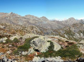
• Rifugio Dondena - Champorcher Alte Vie Website: http://www.lovevda.it/it/banca-dati/7/alte-vie/valle-d-aosta/rifugi...
![Tour Zu Fuß Champorcher - Alta Via n. 2 della Valle d'Aosta - Tappa 13 - Photo](https://media.geolcdn.com/t/350/260/69a2f729-076d-4f56-aeb2-68e9040ba56b.jpeg&format=jpg&maxdim=2)
![Zu Fuß Zu Fuß](https://static1.geolcdn.com/sitytour/trail-icons/100.png)
Km
Zu Fuß
![](/images/other/stat-length.png)
![](https://static1.geolcdn.com/siteimages/upload/files/1508320355ic_sort_den_pos_24dp.png)
![](https://static1.geolcdn.com/siteimages/upload/files/1508320355ic_sort_den_neg_24dp.png)
![](https://static1.geolcdn.com/siteimages/upload/files/16400158638029165_repeat_loop_refresh_sync_direction_icon.png)
• Champorcher - Crest Alte Vie Website: http://www.lovevda.it/it/banca-dati/7/alte-vie/valle-d-aosta/champorcher-cres...
![Tour Zu Fuß Champorcher - Sentiero 5C - Cuneu-Col Fussy - Photo](https://media.geolcdn.com/t/350/260/e59eec27-d654-4d69-986e-2d8d0facddd9.jpeg&format=jpg&maxdim=2)
![Zu Fuß Zu Fuß](https://static1.geolcdn.com/sitytour/trail-icons/100.png)
Km
Zu Fuß
![](/images/other/stat-length.png)
![](https://static1.geolcdn.com/siteimages/upload/files/1508320355ic_sort_den_pos_24dp.png)
![](https://static1.geolcdn.com/siteimages/upload/files/1508320355ic_sort_den_neg_24dp.png)
![](https://static1.geolcdn.com/siteimages/upload/files/16400158638029165_repeat_loop_refresh_sync_direction_icon.png)
![Tour Wandern Champorcher - Alta via val d’Aoste2 etape8 (Champorcher-Crest) - Photo](https://media.geolcdn.com/t/350/260/ext.jpg?maxdim=2&url=https%3A%2F%2Fstatic1.geolcdn.com%2Fsiteimages%2Fupload%2Ffiles%2F1553511878bg_sport_marche.png)
![Wandern Wandern](https://static1.geolcdn.com/sitytour/trail-icons/101.png)
Km
Wandern
![](/images/other/stat-length.png)
![](https://static1.geolcdn.com/siteimages/upload/files/1508320355ic_sort_den_pos_24dp.png)
![](https://static1.geolcdn.com/siteimages/upload/files/1508320355ic_sort_den_neg_24dp.png)
![](https://static1.geolcdn.com/siteimages/upload/files/16400158638029165_repeat_loop_refresh_sync_direction_icon.png)
4 Angezeigte Touren bei 4
Kostenlosegpshiking-Anwendung