


14 km | 17,5 km-effort
Camps-Saint-Mathurin-Léobazel : Entdecken Sie die besten Touren : 8 wandern und 1 laufen. Alle diese Touren, Trails, Routen und Outdoor-Aktivitäten sind in unseren SityTrail-Apps für Smartphones und Tablets verfügbar.
Wandern


Wandern
Wandern
Wandern

Laufen
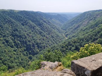
• Vallée de la Cere

Wandern
Wandern
Wandern
Wandern
9 Angezeigte Touren bei 9
Kostenlosegpshiking-Anwendung
 SityTrail
IGN / Geografische Institute
SityTrail World
Die Welt öffnet sich für Sie