![](/images/other/stat-length.png)
- Touren
- Zu Fuß
- Spain
- Autonome Gemeinschaft Madrid
- Unbekannt
Unbekannt, Autonome Gemeinschaft Madrid, Zu Fuß: Die besten Touren, Trails, Trecks und Wanderungen
Unbekannt : Entdecken Sie die besten Touren : 44 zu fuß und 32 wandern. Alle diese Touren, Trails, Routen und Outdoor-Aktivitäten sind in unseren SityTrail-Apps für Smartphones und Tablets verfügbar.
Die besten Spuren (76)
![Tour Zu Fuß Patones - Ruta 2: Vuelta al Cabezo - Photo](https://media.geolcdn.com/t/350/260/80303621-1a36-4c2e-851d-dc6422f4229b.jpeg&format=jpg&maxdim=2)
![Zu Fuß Zu Fuß](https://static1.geolcdn.com/sitytour/trail-icons/100.png)
Km
Zu Fuß
![](/images/other/stat-length.png)
![](https://static1.geolcdn.com/siteimages/upload/files/1508320355ic_sort_den_pos_24dp.png)
![](https://static1.geolcdn.com/siteimages/upload/files/1508320355ic_sort_den_neg_24dp.png)
![](https://static1.geolcdn.com/siteimages/upload/files/16400158638029165_repeat_loop_refresh_sync_direction_icon.png)
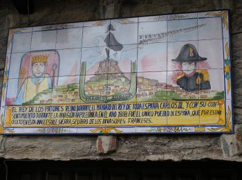
• La ruta 2 Vuelta a El Cabezo es un recorrido para acceder a Patones de Arriba y conocer su entorno. Website: https:/...
![Tour Zu Fuß Patones - Ruta 1: Subida al Cancho de la Cabeza por el Arroyo de Patones - Photo](https://media.geolcdn.com/t/350/260/a1a0f8f0-8b91-49bc-a1de-bdb9005ea52d.jpeg&format=jpg&maxdim=2)
![Zu Fuß Zu Fuß](https://static1.geolcdn.com/sitytour/trail-icons/100.png)
Km
Zu Fuß
![](/images/other/stat-length.png)
![](https://static1.geolcdn.com/siteimages/upload/files/1508320355ic_sort_den_pos_24dp.png)
![](https://static1.geolcdn.com/siteimages/upload/files/1508320355ic_sort_den_neg_24dp.png)
![](https://static1.geolcdn.com/siteimages/upload/files/16400158638029165_repeat_loop_refresh_sync_direction_icon.png)
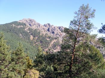
• En la subida al Cancho de la Cabeza descubre una impresionante vista panorámica. Ruta circular de cuatro horas de dur...
![Tour Zu Fuß Canencia - Senda del Arroyo del Sestil del Maíllo y de la Ladera de Mojonavalle - Photo](https://media.geolcdn.com/t/350/260/f22f805a-f104-4f57-ac21-062d0d0b219f.jpeg&format=jpg&maxdim=2)
![Zu Fuß Zu Fuß](https://static1.geolcdn.com/sitytour/trail-icons/100.png)
Km
Zu Fuß
![](/images/other/stat-length.png)
![](https://static1.geolcdn.com/siteimages/upload/files/1508320355ic_sort_den_pos_24dp.png)
![](https://static1.geolcdn.com/siteimages/upload/files/1508320355ic_sort_den_neg_24dp.png)
![](https://static1.geolcdn.com/siteimages/upload/files/16400158638029165_repeat_loop_refresh_sync_direction_icon.png)
• Website: http://sendasdemadrid.es/sendas/index.php?senda=98
![Tour Zu Fuß Manzanares el Real - [RV 22] Garganta de la Camorza - Photo](https://media.geolcdn.com/t/350/260/90bbe6fd-f585-4379-a530-b8909ea4cd65.jpeg&format=jpg&maxdim=2)
![Zu Fuß Zu Fuß](https://static1.geolcdn.com/sitytour/trail-icons/100.png)
Km
Zu Fuß
![](/images/other/stat-length.png)
![](https://static1.geolcdn.com/siteimages/upload/files/1508320355ic_sort_den_pos_24dp.png)
![](https://static1.geolcdn.com/siteimages/upload/files/1508320355ic_sort_den_neg_24dp.png)
![](https://static1.geolcdn.com/siteimages/upload/files/16400158638029165_repeat_loop_refresh_sync_direction_icon.png)
• Website: https://www.parquenacionalsierraguadarrama.es/
![Tour Zu Fuß Manzanares el Real - [RV 20] Collado de la Dehesilla - Photo](https://media.geolcdn.com/t/350/260/14f6a6c8-b3ec-4ba1-b1d6-fe22cff41c84.jpeg&format=jpg&maxdim=2)
![Zu Fuß Zu Fuß](https://static1.geolcdn.com/sitytour/trail-icons/100.png)
Km
Zu Fuß
![](/images/other/stat-length.png)
![](https://static1.geolcdn.com/siteimages/upload/files/1508320355ic_sort_den_pos_24dp.png)
![](https://static1.geolcdn.com/siteimages/upload/files/1508320355ic_sort_den_neg_24dp.png)
![](https://static1.geolcdn.com/siteimages/upload/files/16400158638029165_repeat_loop_refresh_sync_direction_icon.png)
• Website: https://www.parquenacionalsierraguadarrama.es/
![Tour Zu Fuß Manzanares el Real - [RV 21] Circular Collado Cabrón - Photo](https://media.geolcdn.com/t/350/260/08dd2715-3a1e-44a0-9842-91629ab6f415.jpeg&format=jpg&maxdim=2)
![Zu Fuß Zu Fuß](https://static1.geolcdn.com/sitytour/trail-icons/100.png)
Km
Zu Fuß
![](/images/other/stat-length.png)
![](https://static1.geolcdn.com/siteimages/upload/files/1508320355ic_sort_den_pos_24dp.png)
![](https://static1.geolcdn.com/siteimages/upload/files/1508320355ic_sort_den_neg_24dp.png)
![](https://static1.geolcdn.com/siteimages/upload/files/16400158638029165_repeat_loop_refresh_sync_direction_icon.png)
• Website: https://www.parquenacionalsierraguadarrama.es/
![Tour Zu Fuß San Lorenzo de El Escorial - Senda de los Tesoros de Abantos - Photo](https://media.geolcdn.com/t/350/260/21e19b6b-380a-4dd8-88ef-88c810faa471.jpeg&format=jpg&maxdim=2)
![Zu Fuß Zu Fuß](https://static1.geolcdn.com/sitytour/trail-icons/100.png)
Km
Zu Fuß
![](/images/other/stat-length.png)
![](https://static1.geolcdn.com/siteimages/upload/files/1508320355ic_sort_den_pos_24dp.png)
![](https://static1.geolcdn.com/siteimages/upload/files/1508320355ic_sort_den_neg_24dp.png)
![](https://static1.geolcdn.com/siteimages/upload/files/16400158638029165_repeat_loop_refresh_sync_direction_icon.png)
• Website: http://sendasdemadrid.es/sendas/ficheros/pdf/Folleto_Senda_54_Tesoros_Abantos_2012.pdf
![Tour Zu Fuß Cobeña - Ruta 4: Valle de Arriba y el Alfalfar - Photo](https://media.geolcdn.com/t/350/260/bfcff4c7-ebc6-4c85-b941-6a0ad70bca90.jpeg&format=jpg&maxdim=2)
![Zu Fuß Zu Fuß](https://static1.geolcdn.com/sitytour/trail-icons/100.png)
Km
Zu Fuß
![](/images/other/stat-length.png)
![](https://static1.geolcdn.com/siteimages/upload/files/1508320355ic_sort_den_pos_24dp.png)
![](https://static1.geolcdn.com/siteimages/upload/files/1508320355ic_sort_den_neg_24dp.png)
![](https://static1.geolcdn.com/siteimages/upload/files/16400158638029165_repeat_loop_refresh_sync_direction_icon.png)
• Trail created by Ayuntamiento de Cobeña.
![Tour Zu Fuß Cobeña - Ruta 5: Valle de Arriba y la ZEPA](https://media.geolcdn.com/t/350/260/bfcff4c7-ebc6-4c85-b941-6a0ad70bca90.jpeg&format=jpg&maxdim=2)
![Zu Fuß Zu Fuß](https://static1.geolcdn.com/sitytour/trail-icons/100.png)
Km
Zu Fuß
![](/images/other/stat-length.png)
![](https://static1.geolcdn.com/siteimages/upload/files/1508320355ic_sort_den_pos_24dp.png)
![](https://static1.geolcdn.com/siteimages/upload/files/1508320355ic_sort_den_neg_24dp.png)
![](https://static1.geolcdn.com/siteimages/upload/files/16400158638029165_repeat_loop_refresh_sync_direction_icon.png)
• Trail created by Ayuntamiento de Cobeña.
![Tour Zu Fuß Cobeña - Ruta 1: Valle de Abajo y de los medios cerealistas - Photo](https://media.geolcdn.com/t/350/260/446b0355-34e9-4e9c-adcd-7ccfeddf1f79.jpeg&format=jpg&maxdim=2)
![Zu Fuß Zu Fuß](https://static1.geolcdn.com/sitytour/trail-icons/100.png)
Km
Zu Fuß
![](/images/other/stat-length.png)
![](https://static1.geolcdn.com/siteimages/upload/files/1508320355ic_sort_den_pos_24dp.png)
![](https://static1.geolcdn.com/siteimages/upload/files/1508320355ic_sort_den_neg_24dp.png)
![](https://static1.geolcdn.com/siteimages/upload/files/16400158638029165_repeat_loop_refresh_sync_direction_icon.png)
• Trail created by Ayuntamiento de Cobeña.
![Tour Zu Fuß Cobeña - Ruta 2: Valle de Arriba y la Dehesa de Cobeña - Photo](https://media.geolcdn.com/t/350/260/7f8f8504-2533-4ed1-9c14-0c59fdcd532f.jpeg&format=jpg&maxdim=2)
![Zu Fuß Zu Fuß](https://static1.geolcdn.com/sitytour/trail-icons/100.png)
Km
Zu Fuß
![](/images/other/stat-length.png)
![](https://static1.geolcdn.com/siteimages/upload/files/1508320355ic_sort_den_pos_24dp.png)
![](https://static1.geolcdn.com/siteimages/upload/files/1508320355ic_sort_den_neg_24dp.png)
![](https://static1.geolcdn.com/siteimages/upload/files/16400158638029165_repeat_loop_refresh_sync_direction_icon.png)
• Trail created by Ayuntamiento de Cobeña.
![Tour Zu Fuß Alcalá de Henares - Ruta del Ecce-Homo - Photo](https://media.geolcdn.com/t/350/260/fe0b2387-7904-4543-87de-7d51e4741cd1.jpeg&format=jpg&maxdim=2)
![Zu Fuß Zu Fuß](https://static1.geolcdn.com/sitytour/trail-icons/100.png)
Km
Zu Fuß
![](/images/other/stat-length.png)
![](https://static1.geolcdn.com/siteimages/upload/files/1508320355ic_sort_den_pos_24dp.png)
![](https://static1.geolcdn.com/siteimages/upload/files/1508320355ic_sort_den_neg_24dp.png)
![](https://static1.geolcdn.com/siteimages/upload/files/16400158638029165_repeat_loop_refresh_sync_direction_icon.png)
• Website: http://www.loscerrosdealcala.es/rutas/ruta-del-ecce-homo/
![Tour Zu Fuß Alcalá de Henares - Ruta del Castillo Árabe - Photo](https://media.geolcdn.com/t/350/260/a61325ec-480b-468b-ac08-38b5285b8093.jpeg&format=jpg&maxdim=2)
![Zu Fuß Zu Fuß](https://static1.geolcdn.com/sitytour/trail-icons/100.png)
Km
Zu Fuß
![](/images/other/stat-length.png)
![](https://static1.geolcdn.com/siteimages/upload/files/1508320355ic_sort_den_pos_24dp.png)
![](https://static1.geolcdn.com/siteimages/upload/files/1508320355ic_sort_den_neg_24dp.png)
![](https://static1.geolcdn.com/siteimages/upload/files/16400158638029165_repeat_loop_refresh_sync_direction_icon.png)
• Website: http://www.loscerrosdealcala.es/rutas/ruta-del-castillo-%C3%A1rabe/
![Tour Zu Fuß Alcalá de Henares - Ruta de la Puerta Verde - Photo](https://media.geolcdn.com/t/350/260/fe0b2387-7904-4543-87de-7d51e4741cd1.jpeg&format=jpg&maxdim=2)
![Zu Fuß Zu Fuß](https://static1.geolcdn.com/sitytour/trail-icons/100.png)
Km
Zu Fuß
![](/images/other/stat-length.png)
![](https://static1.geolcdn.com/siteimages/upload/files/1508320355ic_sort_den_pos_24dp.png)
![](https://static1.geolcdn.com/siteimages/upload/files/1508320355ic_sort_den_neg_24dp.png)
![](https://static1.geolcdn.com/siteimages/upload/files/16400158638029165_repeat_loop_refresh_sync_direction_icon.png)
• Website: http://www.loscerrosdealcala.es/rutas/ruta-de-la-puerta-verde/
![Tour Zu Fuß Garganta de los Montes - ES-PR-29 - Photo](https://media.geolcdn.com/t/350/260/d05d637c-a197-48c4-9a9c-3f28707573a8.jpeg&format=jpg&maxdim=2)
![Zu Fuß Zu Fuß](https://static1.geolcdn.com/sitytour/trail-icons/100.png)
Km
Zu Fuß
![](/images/other/stat-length.png)
![](https://static1.geolcdn.com/siteimages/upload/files/1508320355ic_sort_den_pos_24dp.png)
![](https://static1.geolcdn.com/siteimages/upload/files/1508320355ic_sort_den_neg_24dp.png)
![](https://static1.geolcdn.com/siteimages/upload/files/16400158638029165_repeat_loop_refresh_sync_direction_icon.png)
![Tour Zu Fuß Guadarrama - [SL-M 44006] Bosque plateado - Photo](https://media.geolcdn.com/t/350/260/30fdfff7-6c5a-4a51-b389-d27391829f84.jpeg&format=jpg&maxdim=2)
![Zu Fuß Zu Fuß](https://static1.geolcdn.com/sitytour/trail-icons/100.png)
Km
Zu Fuß
![](/images/other/stat-length.png)
![](https://static1.geolcdn.com/siteimages/upload/files/1508320355ic_sort_den_pos_24dp.png)
![](https://static1.geolcdn.com/siteimages/upload/files/1508320355ic_sort_den_neg_24dp.png)
![](https://static1.geolcdn.com/siteimages/upload/files/16400158638029165_repeat_loop_refresh_sync_direction_icon.png)
![Tour Zu Fuß Manzanares el Real - [RV 23] Collado Quebrantahuesos - Photo](https://media.geolcdn.com/t/350/260/52736da5-4c36-4bd1-8ff5-641fc5706541.jpeg&format=jpg&maxdim=2)
![Zu Fuß Zu Fuß](https://static1.geolcdn.com/sitytour/trail-icons/100.png)
Km
Zu Fuß
![](/images/other/stat-length.png)
![](https://static1.geolcdn.com/siteimages/upload/files/1508320355ic_sort_den_pos_24dp.png)
![](https://static1.geolcdn.com/siteimages/upload/files/1508320355ic_sort_den_neg_24dp.png)
![](https://static1.geolcdn.com/siteimages/upload/files/16400158638029165_repeat_loop_refresh_sync_direction_icon.png)
• Website: https://www.parquenacionalsierraguadarrama.es/
![Tour Zu Fuß Rascafría - [RV 5.2] Mirador de los Robledos - Photo](https://media.geolcdn.com/t/350/260/832bcf1e-0c3e-4069-9b8e-00ba1134c549.jpeg&format=jpg&maxdim=2)
![Zu Fuß Zu Fuß](https://static1.geolcdn.com/sitytour/trail-icons/100.png)
Km
Zu Fuß
![](/images/other/stat-length.png)
![](https://static1.geolcdn.com/siteimages/upload/files/1508320355ic_sort_den_pos_24dp.png)
![](https://static1.geolcdn.com/siteimages/upload/files/1508320355ic_sort_den_neg_24dp.png)
![](https://static1.geolcdn.com/siteimages/upload/files/16400158638029165_repeat_loop_refresh_sync_direction_icon.png)
![Tour Zu Fuß Rascafría - [RV 1.1] Camino del Ejido - Photo](https://media.geolcdn.com/t/350/260/f9f079e9-0b81-4f1d-9a2e-9296fff2ffa1.jpeg&format=jpg&maxdim=2)
![Zu Fuß Zu Fuß](https://static1.geolcdn.com/sitytour/trail-icons/100.png)
Km
Zu Fuß
![](/images/other/stat-length.png)
![](https://static1.geolcdn.com/siteimages/upload/files/1508320355ic_sort_den_pos_24dp.png)
![](https://static1.geolcdn.com/siteimages/upload/files/1508320355ic_sort_den_neg_24dp.png)
![](https://static1.geolcdn.com/siteimages/upload/files/16400158638029165_repeat_loop_refresh_sync_direction_icon.png)
![Tour Zu Fuß Rascafría - [RV 4] Puerto del Reventón - Photo](https://media.geolcdn.com/t/350/260/f9f079e9-0b81-4f1d-9a2e-9296fff2ffa1.jpeg&format=jpg&maxdim=2)
![Zu Fuß Zu Fuß](https://static1.geolcdn.com/sitytour/trail-icons/100.png)
Km
Zu Fuß
![](/images/other/stat-length.png)
![](https://static1.geolcdn.com/siteimages/upload/files/1508320355ic_sort_den_pos_24dp.png)
![](https://static1.geolcdn.com/siteimages/upload/files/1508320355ic_sort_den_neg_24dp.png)
![](https://static1.geolcdn.com/siteimages/upload/files/16400158638029165_repeat_loop_refresh_sync_direction_icon.png)
20 Angezeigte Touren bei 76
Kostenlosegpshiking-Anwendung
Aktivitäten
Nahegelegene Regionen
- Alcalá de Henares
- Algete
- Alpedrete
- Aranjuez
- Arganda del Rey
- Becerril de la Sierra
- Boadilla del Monte
- Canencia
- Cercedilla
- Cobeña
- Collado Villalba
- Colmenar Viejo
- Colmenar del Arroyo
- El Berrueco
- El Escorial
- El Vellón
- Fuenlabrada
- Galapagar
- Garganta de los Montes
- Getafe
- Guadarrama
- Leganés
- Los Baldíos
- Lozoya
- Madrid
- Manzanares el Real
- Navacerrada
- Navalcarnero
- Patones
- Pelayos de la Presa
- Pozuelo de Alarcón
- Puebla de la Sierra
- Rascafría
- Rivas-Vaciamadrid
- San Fernando de Henares
- San Lorenzo de El Escorial
- San Martín de Valdeiglesias
- San Sebastián de los Reyes
- Santa María de la Alameda
- Tres Cantos
- Valdemanco