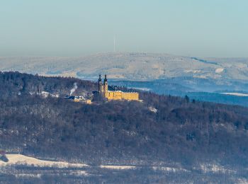
![](/images/other/stat-length.png)
- Touren
- Zu Fuß
- Germany
- Bayern
- Landkreis Lichtenfels
- Ebensfeld
Ebensfeld, Landkreis Lichtenfels, Zu Fuß: Die besten Touren, Trails, Trecks und Wanderungen
Ebensfeld : Entdecken Sie die besten Touren : 14 zu fuß. Alle diese Touren, Trails, Routen und Outdoor-Aktivitäten sind in unseren SityTrail-Apps für Smartphones und Tablets verfügbar.
Die besten Spuren (14)
![Tour Zu Fuß Ebensfeld - Verbindungsweg gelber Balken (Gleusdorf) - Busendorf - Tafel 2688 - Photo](https://media.geolcdn.com/t/350/260/f6fb59a1-0b68-48d8-85fd-eef716c17b1f.jpeg&format=jpg&maxdim=2)
![Zu Fuß Zu Fuß](https://static1.geolcdn.com/sitytour/trail-icons/100.png)
Km
Zu Fuß
![](/images/other/stat-length.png)
![](https://static1.geolcdn.com/siteimages/upload/files/1508320355ic_sort_den_pos_24dp.png)
![](https://static1.geolcdn.com/siteimages/upload/files/1508320355ic_sort_den_neg_24dp.png)
![](https://static1.geolcdn.com/siteimages/upload/files/16400158638029165_repeat_loop_refresh_sync_direction_icon.png)
• Trail created by Landkreis Lichtenfels. Symbol: Gelber Strich auf weißem Hintergrund
![Tour Zu Fuß Ebensfeld - Kleine Döringstädter Runde - Photo](https://media.geolcdn.com/t/350/260/fe7ca50c-73e6-4322-9c79-2d13983beab7.jpeg&format=jpg&maxdim=2)
![Zu Fuß Zu Fuß](https://static1.geolcdn.com/sitytour/trail-icons/100.png)
Km
Zu Fuß
![](/images/other/stat-length.png)
![](https://static1.geolcdn.com/siteimages/upload/files/1508320355ic_sort_den_pos_24dp.png)
![](https://static1.geolcdn.com/siteimages/upload/files/1508320355ic_sort_den_neg_24dp.png)
![](https://static1.geolcdn.com/siteimages/upload/files/16400158638029165_repeat_loop_refresh_sync_direction_icon.png)
• Trail created by Landkreis Lichtenfels. Symbol: Weiße 3 zwischen zwei Punkten auf rotem Hintergrund
![Tour Zu Fuß Ebensfeld - Freiberger Runde - Photo](https://media.geolcdn.com/t/350/260/140e8397-a66a-4fe1-8fb1-28958a4a686a.jpeg&format=jpg&maxdim=2)
![Zu Fuß Zu Fuß](https://static1.geolcdn.com/sitytour/trail-icons/100.png)
Km
Zu Fuß
![](/images/other/stat-length.png)
![](https://static1.geolcdn.com/siteimages/upload/files/1508320355ic_sort_den_pos_24dp.png)
![](https://static1.geolcdn.com/siteimages/upload/files/1508320355ic_sort_den_neg_24dp.png)
![](https://static1.geolcdn.com/siteimages/upload/files/16400158638029165_repeat_loop_refresh_sync_direction_icon.png)
• Trail created by Landkreis Lichtenfels. Zwischen T 2636 und Wanderwegweiser 20 unmarkiert Symbol: Blauer Strich auf...
![Tour Zu Fuß Ebensfeld - Große Kleukheimer Runde, auch Kelbachtaler Höhenweg (große Runde) - Photo](https://media.geolcdn.com/t/350/260/9f8e833d-f213-4e22-9238-de8dc2499235.jpeg&format=jpg&maxdim=2)
![Zu Fuß Zu Fuß](https://static1.geolcdn.com/sitytour/trail-icons/100.png)
Km
Zu Fuß
![](/images/other/stat-length.png)
![](https://static1.geolcdn.com/siteimages/upload/files/1508320355ic_sort_den_pos_24dp.png)
![](https://static1.geolcdn.com/siteimages/upload/files/1508320355ic_sort_den_neg_24dp.png)
![](https://static1.geolcdn.com/siteimages/upload/files/16400158638029165_repeat_loop_refresh_sync_direction_icon.png)
• Trail created by Kelbachtaler Blasmusik Prächting. Symbol: Notenlinie mit Violinenschlüssel auf gelbem Hintergrund
![Tour Zu Fuß Ebensfeld - Kleine Kleukheimer Runde, auch Kelbachtaler Höhenweg (kleine Runde) - Photo](https://media.geolcdn.com/t/350/260/e3a4154e-10d8-4726-bf91-6602cdbadc86.jpeg&format=jpg&maxdim=2)
![Zu Fuß Zu Fuß](https://static1.geolcdn.com/sitytour/trail-icons/100.png)
Km
Zu Fuß
![](/images/other/stat-length.png)
![](https://static1.geolcdn.com/siteimages/upload/files/1508320355ic_sort_den_pos_24dp.png)
![](https://static1.geolcdn.com/siteimages/upload/files/1508320355ic_sort_den_neg_24dp.png)
![](https://static1.geolcdn.com/siteimages/upload/files/16400158638029165_repeat_loop_refresh_sync_direction_icon.png)
• Trail created by Kelbachtaler Blasmusik Prächting. Markierung teilweise unvollständig, keine Unterscheidung zur groß...
![Tour Zu Fuß Ebensfeld - Pferdsfelder Kapellenweg - Photo](https://media.geolcdn.com/t/350/260/5d054942-eb89-472d-bcb1-1caf1d457b80.jpeg&format=jpg&maxdim=2)
![Zu Fuß Zu Fuß](https://static1.geolcdn.com/sitytour/trail-icons/100.png)
Km
Zu Fuß
![](/images/other/stat-length.png)
![](https://static1.geolcdn.com/siteimages/upload/files/1508320355ic_sort_den_pos_24dp.png)
![](https://static1.geolcdn.com/siteimages/upload/files/1508320355ic_sort_den_neg_24dp.png)
![](https://static1.geolcdn.com/siteimages/upload/files/16400158638029165_repeat_loop_refresh_sync_direction_icon.png)
• Trail created by Landkreis Lichtenfels. Symbol: Weiße 6 zwischen zwei Punkten auf rotem Hintergrund
![Tour Zu Fuß Ebensfeld - Küpser Lindenweg - Photo](https://media.geolcdn.com/t/350/260/a291f203-055a-4679-9cff-c005120e0b93.jpeg&format=jpg&maxdim=2)
![Zu Fuß Zu Fuß](https://static1.geolcdn.com/sitytour/trail-icons/100.png)
Km
Zu Fuß
![](/images/other/stat-length.png)
![](https://static1.geolcdn.com/siteimages/upload/files/1508320355ic_sort_den_pos_24dp.png)
![](https://static1.geolcdn.com/siteimages/upload/files/1508320355ic_sort_den_neg_24dp.png)
![](https://static1.geolcdn.com/siteimages/upload/files/16400158638029165_repeat_loop_refresh_sync_direction_icon.png)
• teilweise alte Markierung Küpser Rundweg Symbol: blauer Kreis auf weißem Grund
![Tour Zu Fuß Ebensfeld - Keltenweg E - Photo](https://media.geolcdn.com/t/350/260/ebea86b0-6d87-4627-a203-bc3b8143ce05.jpeg&format=jpg&maxdim=2)
![Zu Fuß Zu Fuß](https://static1.geolcdn.com/sitytour/trail-icons/100.png)
Km
Zu Fuß
![](/images/other/stat-length.png)
![](https://static1.geolcdn.com/siteimages/upload/files/1508320355ic_sort_den_pos_24dp.png)
![](https://static1.geolcdn.com/siteimages/upload/files/1508320355ic_sort_den_neg_24dp.png)
![](https://static1.geolcdn.com/siteimages/upload/files/16400158638029165_repeat_loop_refresh_sync_direction_icon.png)
• Trail created by Landkreis Lichtenfels. Symbol: Keltisches Gefäß und Ammonit auf gelbem Hrund
![Tour Zu Fuß Ebensfeld - Mainseeweg - Photo](https://media.geolcdn.com/t/350/260/b724cbd5-81b4-44ca-9076-1b739bf964b6.jpeg&format=jpg&maxdim=2)
![Zu Fuß Zu Fuß](https://static1.geolcdn.com/sitytour/trail-icons/100.png)
Km
Zu Fuß
![](/images/other/stat-length.png)
![](https://static1.geolcdn.com/siteimages/upload/files/1508320355ic_sort_den_pos_24dp.png)
![](https://static1.geolcdn.com/siteimages/upload/files/1508320355ic_sort_den_neg_24dp.png)
![](https://static1.geolcdn.com/siteimages/upload/files/16400158638029165_repeat_loop_refresh_sync_direction_icon.png)
• Trail created by Landkreis Lichtenfels. Symbol: Weiße 10 zwischen zwei Punkten auf rotem Hintergrund
![Tour Zu Fuß Ebensfeld - Ebensfelder Main-Runde oder Wiesener Rundweg - Photo](https://media.geolcdn.com/t/350/260/6c06bf63-2b39-4917-bff6-048fb7ba0492.jpeg&format=jpg&maxdim=2)
![Zu Fuß Zu Fuß](https://static1.geolcdn.com/sitytour/trail-icons/100.png)
Km
Zu Fuß
![](/images/other/stat-length.png)
![](https://static1.geolcdn.com/siteimages/upload/files/1508320355ic_sort_den_pos_24dp.png)
![](https://static1.geolcdn.com/siteimages/upload/files/1508320355ic_sort_den_neg_24dp.png)
![](https://static1.geolcdn.com/siteimages/upload/files/16400158638029165_repeat_loop_refresh_sync_direction_icon.png)
• Trail created by Landkreis Lichtenfels. Symbol: Weiße 5 zwischen zwei Punkten auf rotem Hintergrund
![Tour Zu Fuß Ebensfeld - Veitsberg Höhenweg - Photo](https://media.geolcdn.com/t/350/260/7060b700-6a84-4530-9d00-4b0dcb3b30a5.jpeg&format=jpg&maxdim=2)
![Zu Fuß Zu Fuß](https://static1.geolcdn.com/sitytour/trail-icons/100.png)
Km
Zu Fuß
![](/images/other/stat-length.png)
![](https://static1.geolcdn.com/siteimages/upload/files/1508320355ic_sort_den_pos_24dp.png)
![](https://static1.geolcdn.com/siteimages/upload/files/1508320355ic_sort_den_neg_24dp.png)
![](https://static1.geolcdn.com/siteimages/upload/files/16400158638029165_repeat_loop_refresh_sync_direction_icon.png)
• Trail created by Landkreis Lichtenfels;Tourismusverein Ebensfeld. teilweise alte Markierung Veitsbergweg Symbol: We...
![Tour Zu Fuß Ebensfeld - Horsdorfer Weg - Photo](https://media.geolcdn.com/t/350/260/6c06bf63-2b39-4917-bff6-048fb7ba0492.jpeg&format=jpg&maxdim=2)
![Zu Fuß Zu Fuß](https://static1.geolcdn.com/sitytour/trail-icons/100.png)
Km
Zu Fuß
![](/images/other/stat-length.png)
![](https://static1.geolcdn.com/siteimages/upload/files/1508320355ic_sort_den_pos_24dp.png)
![](https://static1.geolcdn.com/siteimages/upload/files/1508320355ic_sort_den_neg_24dp.png)
![](https://static1.geolcdn.com/siteimages/upload/files/16400158638029165_repeat_loop_refresh_sync_direction_icon.png)
• Trail created by Landkreis Lichtenfels. Symbol: Blaue Raute auf weißem Hintergrund
![Tour Zu Fuß Ebensfeld - Große Döringstädter Runde - Photo](https://media.geolcdn.com/t/350/260/d45a4ad8-b67c-481f-ae88-ea0e13415335.jpeg&format=jpg&maxdim=2)
![Zu Fuß Zu Fuß](https://static1.geolcdn.com/sitytour/trail-icons/100.png)
Km
Zu Fuß
![](/images/other/stat-length.png)
![](https://static1.geolcdn.com/siteimages/upload/files/1508320355ic_sort_den_pos_24dp.png)
![](https://static1.geolcdn.com/siteimages/upload/files/1508320355ic_sort_den_neg_24dp.png)
![](https://static1.geolcdn.com/siteimages/upload/files/16400158638029165_repeat_loop_refresh_sync_direction_icon.png)
• Trail created by Landkreis Lichtenfels. teilweise noch alte Markierung (blaue 2 weißem Grund) Symbol: Weiße 2 zwisc...
![Tour Zu Fuß Ebensfeld - Ummersberg Runde - Photo](https://media.geolcdn.com/t/350/260/d18b70c2-4be8-47e5-83ba-ad3d52cd6988.jpeg&format=jpg&maxdim=2)
![Zu Fuß Zu Fuß](https://static1.geolcdn.com/sitytour/trail-icons/100.png)
Km
Zu Fuß
![](/images/other/stat-length.png)
![](https://static1.geolcdn.com/siteimages/upload/files/1508320355ic_sort_den_pos_24dp.png)
![](https://static1.geolcdn.com/siteimages/upload/files/1508320355ic_sort_den_neg_24dp.png)
![](https://static1.geolcdn.com/siteimages/upload/files/16400158638029165_repeat_loop_refresh_sync_direction_icon.png)
• Trail created by Landkreis Lichtenfels. Symbol: Weiße 1 zwischen zwei Punkten auf rotem Hintergrund
14 Angezeigte Touren bei 14
Kostenlosegpshiking-Anwendung