![](/images/other/stat-length.png)
- Touren
- Zu Fuß
- Austria
- Niederösterreich
- Bezirk Baden
- Leobersdorf
Leobersdorf, Bezirk Baden, Zu Fuß: Die besten Touren, Trails, Trecks und Wanderungen
Leobersdorf : Entdecken Sie die besten Touren : 7 zu fuß. Alle diese Touren, Trails, Routen und Outdoor-Aktivitäten sind in unseren SityTrail-Apps für Smartphones und Tablets verfügbar.
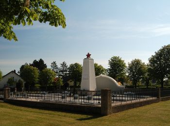
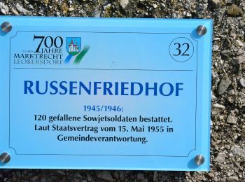
Die besten Spuren (7)
![Tour Zu Fuß Leobersdorf - Tecon Runde](https://media.geolcdn.com/t/350/260/dce4fc86-6417-49e1-b8ca-7af8d3036dfe.jpeg&format=jpg&maxdim=2)
![Zu Fuß Zu Fuß](https://static1.geolcdn.com/sitytour/trail-icons/100.png)
Km
Zu Fuß
![](/images/other/stat-length.png)
![](https://static1.geolcdn.com/siteimages/upload/files/1508320355ic_sort_den_pos_24dp.png)
![](https://static1.geolcdn.com/siteimages/upload/files/1508320355ic_sort_den_neg_24dp.png)
![](https://static1.geolcdn.com/siteimages/upload/files/16400158638029165_repeat_loop_refresh_sync_direction_icon.png)
• Trail created by RUNNERSFUN Consulting GmbH. Symbol: brauner Pfeil, L5
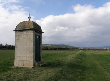
![Tour Zu Fuß Leobersdorf - Mariazellerhof Runde](https://media.geolcdn.com/t/350/260/7ddcadb7-a629-4dc3-be8a-ebd0b6f6be93.jpeg&format=jpg&maxdim=2)
![Zu Fuß Zu Fuß](https://static1.geolcdn.com/sitytour/trail-icons/100.png)
Km
Zu Fuß
![](/images/other/stat-length.png)
![](https://static1.geolcdn.com/siteimages/upload/files/1508320355ic_sort_den_pos_24dp.png)
![](https://static1.geolcdn.com/siteimages/upload/files/1508320355ic_sort_den_neg_24dp.png)
![](https://static1.geolcdn.com/siteimages/upload/files/16400158638029165_repeat_loop_refresh_sync_direction_icon.png)
• Trail created by RUNNERSFUN Consulting GmbH. Symbol: magentafarbener Pfeil, L6
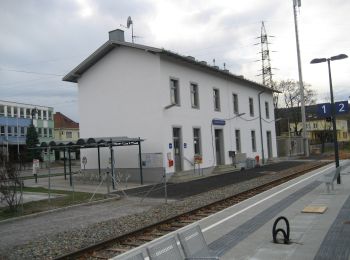
![Tour Zu Fuß Leobersdorf - Karl Neuwirth Runde](https://media.geolcdn.com/t/350/260/7ddcadb7-a629-4dc3-be8a-ebd0b6f6be93.jpeg&format=jpg&maxdim=2)
![Zu Fuß Zu Fuß](https://static1.geolcdn.com/sitytour/trail-icons/100.png)
Km
Zu Fuß
![](/images/other/stat-length.png)
![](https://static1.geolcdn.com/siteimages/upload/files/1508320355ic_sort_den_pos_24dp.png)
![](https://static1.geolcdn.com/siteimages/upload/files/1508320355ic_sort_den_neg_24dp.png)
![](https://static1.geolcdn.com/siteimages/upload/files/16400158638029165_repeat_loop_refresh_sync_direction_icon.png)
• Trail created by RUNNERSFUN Consulting GmbH. Symbol: gelber Pfeil, L4
![Tour Zu Fuß Leobersdorf - Gärtnerei Plank Runde](https://media.geolcdn.com/t/350/260/d608b5bb-984a-47a4-af75-5d637024346a.jpeg&format=jpg&maxdim=2)
![Zu Fuß Zu Fuß](https://static1.geolcdn.com/sitytour/trail-icons/100.png)
Km
Zu Fuß
![](/images/other/stat-length.png)
![](https://static1.geolcdn.com/siteimages/upload/files/1508320355ic_sort_den_pos_24dp.png)
![](https://static1.geolcdn.com/siteimages/upload/files/1508320355ic_sort_den_neg_24dp.png)
![](https://static1.geolcdn.com/siteimages/upload/files/16400158638029165_repeat_loop_refresh_sync_direction_icon.png)
• Trail created by RUNNERSFUN Consulting GmbH. Symbol: hellgrüner Pfeil, L2
![Tour Zu Fuß Leobersdorf - Elektro Wöhrer Runde](https://media.geolcdn.com/t/350/260/827e8c07-dbe5-4805-82e0-ecb99ce65ec1.jpeg&format=jpg&maxdim=2)
![Zu Fuß Zu Fuß](https://static1.geolcdn.com/sitytour/trail-icons/100.png)
Km
Zu Fuß
![](/images/other/stat-length.png)
![](https://static1.geolcdn.com/siteimages/upload/files/1508320355ic_sort_den_pos_24dp.png)
![](https://static1.geolcdn.com/siteimages/upload/files/1508320355ic_sort_den_neg_24dp.png)
![](https://static1.geolcdn.com/siteimages/upload/files/16400158638029165_repeat_loop_refresh_sync_direction_icon.png)
• Trail created by RUNNERSFUN Consulting GmbH. Symbol: schwarzer Pfeil, L7
![Tour Zu Fuß Leobersdorf - Lindenberg (bei Hirtenberg) Rundwanderweg - Photo](https://media.geolcdn.com/t/350/260/5e8959b9-9013-476c-a3f6-655eff8ba54e.jpeg&format=jpg&maxdim=2)
![Zu Fuß Zu Fuß](https://static1.geolcdn.com/sitytour/trail-icons/100.png)
Km
Zu Fuß
![](/images/other/stat-length.png)
![](https://static1.geolcdn.com/siteimages/upload/files/1508320355ic_sort_den_pos_24dp.png)
![](https://static1.geolcdn.com/siteimages/upload/files/1508320355ic_sort_den_neg_24dp.png)
![](https://static1.geolcdn.com/siteimages/upload/files/16400158638029165_repeat_loop_refresh_sync_direction_icon.png)
• Symbol: blau und gelb waagerecht
![Tour Zu Fuß Leobersdorf - Nordic Walking (Brückenlauf) - Photo](https://media.geolcdn.com/t/350/260/ce1a649a-802e-4584-885c-bbc33f93e06c.jpeg&format=jpg&maxdim=2)
![Zu Fuß Zu Fuß](https://static1.geolcdn.com/sitytour/trail-icons/100.png)
Km
Zu Fuß
![](/images/other/stat-length.png)
![](https://static1.geolcdn.com/siteimages/upload/files/1508320355ic_sort_den_pos_24dp.png)
![](https://static1.geolcdn.com/siteimages/upload/files/1508320355ic_sort_den_neg_24dp.png)
![](https://static1.geolcdn.com/siteimages/upload/files/16400158638029165_repeat_loop_refresh_sync_direction_icon.png)
7 Angezeigte Touren bei 7
Kostenlosegpshiking-Anwendung