Tocht Stappen Les Cluses -  Les Cluses-Le Perthus - Photo
 zenyves66
zenyves66

Gebruiker

© OpenStreetMap contributors
Lengte
Lengte
14,6 km
Max. hoogte
Max. hoogte
396 m
Positief hoogteverschil
477 m
Km-Effort
Km-Effort  
21 km
Min. hoogte
Min. hoogte
120 m
Negatief hoogteverschil
475 m
Boucle
Boucle
Ja
Datum van aanmaak :
2018-04-17 20:42:51.889
Laatste wijziging :
2018-04-17 20:42:51.889

(0 Bericht)

Stappen
Stappen
4h00
Moeilijkheid : Medium

Scan deze QR-code om de tocht te openen in de SityTrail-applicatie

Gratisgps-wandelapplicatie

Logo SityTrail SityTrail

IGN / Geografische instituten

SityTrail uit de App Store downloaden SityTrail uit Google Play downloaden

Logo SityTrail SityTrail World

De wereld gaat voor u open

SityTrail uit de App Store downloaden SityTrail uit Google Play downloaden SityTrail op Huawei AppGallery downloaden

Over ons

Tocht Stappen van 14,6 km beschikbaar op Occitanië, Pyrénées-Orientales, Les Cluses. Deze tocht wordt voorgesteld door zenyves66.

Beschrijving

Ballade Patrimoine dans la vallée de la Rome.
Randonnée du Jeudi.

Hoogteprofiel

Plaatsbepaling

Land:
France
Regio :
Occitanië
Departement/Provincie :
Pyrénées-Orientales
Gemeente :
Les Cluses
Locatie:
Unknown
Vertrek:(Dec)
Vertrek:(UTM)
486245 ; 4703951 (31T) N.

Wandeltochten in de omgeving

Tocht Stappen Les Cluses - LES CLUSES 66 - Photo
Stappen
jeff66

Stappen

Gemakkelijk
(9)
Les Cluses, Occitanië, Pyrénées-Orientales, France
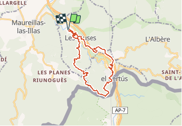
9,4 km | 12,8 km-effort
1h 50min
Ja
Tocht Stappen Saint-Jean-Pla-de-Corts - 66 ST-JEAN-PLA-DE-CORTS, promenade autour du Tech, jusqu'au BOULOU  - Photo
Stappen
jeff66

Stappen

Gemakkelijk
(1)
Saint-Jean-Pla-de-Corts, Occitanië, Pyrénées-Orientales, France
7,9 km | 8,8 km-effort
1h 18min
Ja
Tocht Stappen Maureillas-las-Illas - CERET 66 - les hauts de CERET - ballade en bas Vallespir - dolmen de la Siureda torre Bel Ull  - Photo
Stappen
jeff66

Stappen

Medium
(1)
Maureillas-las-Illas, Occitanië, Pyrénées-Orientales, France
6,5 km | 9,9 km-effort
1h 24min
Ja
Tocht Stappen Le Boulou - LES THERMES DU BOULOU - 66 - Albera viva - PUIG de l'Estella - Photo
Stappen
jeff66

Stappen

Medium
(2)
Le Boulou, Occitanië, Pyrénées-Orientales, France
7,3 km | 11,4 km-effort
1h 32min
Ja
Tocht Hybride fiets Le Boulou - Autour du Boulou (66) - Photo
Hybride fiets
GUIDE
toutankhcarton

Hybride fiets

Gemakkelijk
Le Boulou, Occitanië, Pyrénées-Orientales, France
17 km | 19,5 km-effort
1h 54min
Neen
Tocht Stappen Le Boulou - Pic Estelle (377m) - Le Boulou - Pyrénées orientales (66) - Photo
Stappen
GUIDE
toutankhcarton

Stappen

Heel gemakkelijk
Le Boulou, Occitanië, Pyrénées-Orientales, France
10,9 km | 15,9 km-effort
2h 19min
Ja
Tocht Stappen Montesquieu-des-Albères - montesquieu . puig sant cristau . prieuré Santa maria del villard  . montesquieu - Photo
Stappen
GUIDE
stef789

Stappen

Moeilijk
Montesquieu-des-Albères, Occitanië, Pyrénées-Orientales, France
15,7 km | 31 km-effort
7h 51min
Ja
Tocht Stappen Les Cluses - LES CLUSES 66 - LE PERTHUS -  - Photo
Stappen
jeff66

Stappen

Medium
(2)
Les Cluses, Occitanië, Pyrénées-Orientales, France
14,4 km | 20 km-effort
2h 57min
Ja
Tocht Stappen Le Boulou - Le Boulou, chapelle saint Phillipe, mas d'en Conte - Photo
Stappen
nandaf

Stappen

Medium
(1)
Le Boulou, Occitanië, Pyrénées-Orientales, France
5,2 km | 7,6 km-effort
1h 43min
Ja


Sluiten
Mijn abonnementen