![](/images/other/stat-length.png)
![Tocht Noords wandelen Vandœuvre-lès-Nancy - Vandoeuvre-lès-Nancy 10 130m +185m-19070264 - Photo](https://media.geolcdn.com/t/1900/400/ext.pjpeg?maxdim=2&url=https%3A%2F%2Fstatic1.geolcdn.com%2Fsiteimages%2Fupload%2Ffiles%2F1545311037marcheuse_200dpi.jpg)
Vandoeuvre-lès-Nancy 10 130m +185m-19070264
DanielROLLET
Gebruiker
![Lengte](/images/other/stat-length.png)
Lengte
10,1 km
![Max. hoogte](https://static1.geolcdn.com/siteimages/upload/files/1508320355ic_sort_altitude_max_24dp.png)
Max. hoogte
395 m
![Positief hoogteverschil](https://static1.geolcdn.com/siteimages/upload/files/1508320355ic_sort_den_pos_24dp.png)
Positief hoogteverschil
201 m
![Km-Effort](/images/other/stat-length.png)
Km-Effort
12,8 km
![Min. hoogte](https://static1.geolcdn.com/siteimages/upload/files/1508320355ic_sort_altitude_min_24dp.png)
Min. hoogte
234 m
![Negatief hoogteverschil](https://static1.geolcdn.com/siteimages/upload/files/1508320355ic_sort_den_neg_24dp.png)
Negatief hoogteverschil
207 m
![Boucle](https://static1.geolcdn.com/siteimages/upload/files/16400158638029165_repeat_loop_refresh_sync_direction_icon.png)
Boucle
Ja
Datum van aanmaak :
2024-05-25 11:31:32.223
Laatste wijziging :
2024-05-25 11:42:10.46
![Noords wandelen](https://static1.geolcdn.com/sitytour/trail-icons/102.png)
2h00
Moeilijkheid : Gemakkelijk
![Scan deze QR-code om de tocht te openen in de SityTrail-applicatie](https://capi.geolives.com/qq0zvz2zws4bq2lad0pu/sitytour/trails/4067294/qr.png?size=200)
Gratisgps-wandelapplicatie
Over ons
Tocht Noords wandelen van 10,1 km beschikbaar op Grand Est, Meurthe-et-Moselle, Vandœuvre-lès-Nancy. Deze tocht wordt voorgesteld door DanielROLLET.
Beschrijving
2024 05 25 - Avec Marie- 8h55 à 10h55
Beau temps légèrement couvert
Reco pour Rando Pattes 54
Attention fin du parcours trop raide
Plaatsbepaling
Land:
France
Regio :
Grand Est
Departement/Provincie :
Meurthe-et-Moselle
Gemeente :
Vandœuvre-lès-Nancy
Locatie:
Unknown
Vertrek:(Dec)
Vertrek:(UTM)
290977 ; 5393009 (32U) N.
Opmerkingen
Wandeltochten in de omgeving
![Tocht Te voet Fléville-devant-Nancy - Fléville-devant-Nancy et son château - Photo](https://media.geolcdn.com/t/375/260/ext.jpg?maxdim=2&url=https%3A%2F%2Fmedia.geolcdn.com%2Ff%2Fee7686de-cd52-43ca-b6f5-ed4c3a349bb0.jpeg)
![Te voet Te voet](https://static1.geolcdn.com/sitytour/trail-icons/100.png)
Fléville-devant-Nancy et son château
Te voet
Gemakkelijk
Fléville-devant-Nancy,
Grand Est,
Meurthe-et-Moselle,
France
![](/images/other/stat-length.png)
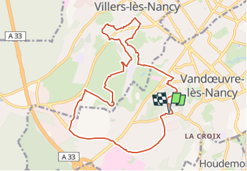
7,9 km | 9,4 km-effort
2h 8min
![](https://static1.geolcdn.com/siteimages/upload/files/16400158638029165_repeat_loop_refresh_sync_direction_icon.png)
Ja
![Tocht Stappen Nancy - Ma dernière avant opération - Photo](https://media.geolcdn.com/t/375/260/ext.jpg?maxdim=2&url=https%3A%2F%2Fstatic1.geolcdn.com%2Fsiteimages%2Fupload%2Ffiles%2F1553511878bg_sport_marche.png)
![Stappen Stappen](https://static1.geolcdn.com/sitytour/trail-icons/101.png)
Ma dernière avant opération
Stappen
Zeer moeilijk
(1)
Nancy,
Grand Est,
Meurthe-et-Moselle,
France
![](/images/other/stat-length.png)
22 km | 25 km-effort
4h 12min
![](https://static1.geolcdn.com/siteimages/upload/files/16400158638029165_repeat_loop_refresh_sync_direction_icon.png)
Ja
![Tocht Stappen Vandœuvre-lès-Nancy - Randonnée USEP 2023 - Photo](https://media.geolcdn.com/t/375/260/ext.jpg?maxdim=2&url=https%3A%2F%2Fstatic1.geolcdn.com%2Fsiteimages%2Fupload%2Ffiles%2F1553511878bg_sport_marche.png)
![Stappen Stappen](https://static1.geolcdn.com/sitytour/trail-icons/101.png)
Randonnée USEP 2023
Stappen
Moeilijk
(1)
Vandœuvre-lès-Nancy,
Grand Est,
Meurthe-et-Moselle,
France
![](/images/other/stat-length.png)
11,7 km | 15,2 km-effort
3h 27min
![](https://static1.geolcdn.com/siteimages/upload/files/16400158638029165_repeat_loop_refresh_sync_direction_icon.png)
Neen
![Tocht Stappen Ludres - marche nuit - Photo](https://media.geolcdn.com/t/375/260/ext.jpg?maxdim=2&url=https%3A%2F%2Fmedia.geolcdn.com%2Ff%2F2c15af7e-0536-4068-be2b-216477912337.jpg)
![Stappen Stappen](https://static1.geolcdn.com/sitytour/trail-icons/101.png)
marche nuit
Stappen
Medium
Ludres,
Grand Est,
Meurthe-et-Moselle,
France
![](/images/other/stat-length.png)
8,7 km | 10,1 km-effort
2h 11min
![](https://static1.geolcdn.com/siteimages/upload/files/16400158638029165_repeat_loop_refresh_sync_direction_icon.png)
Ja
![Tocht Stappen Nancy - Ma rando du jour - Photo](https://media.geolcdn.com/t/375/260/ext.jpg?maxdim=2&url=https%3A%2F%2Fmedia.geolcdn.com%2Ff%2Fc990ad83-2661-43f9-99e0-4498fd5d020a.jpg)
![Stappen Stappen](https://static1.geolcdn.com/sitytour/trail-icons/101.png)
Ma rando du jour
Stappen
Moeilijk
Nancy,
Grand Est,
Meurthe-et-Moselle,
France
![](/images/other/stat-length.png)
35 km | 41 km-effort
5h 55min
![](https://static1.geolcdn.com/siteimages/upload/files/16400158638029165_repeat_loop_refresh_sync_direction_icon.png)
Ja
![Tocht Stappen Nancy - Nancy Gondreville Nancy - Photo](https://media.geolcdn.com/t/375/260/ext.jpg?maxdim=2&url=https%3A%2F%2Fmedia.geolcdn.com%2Ff%2F171b4f53-1717-4b2e-9789-6c40dd8e1481.jpg)
![Stappen Stappen](https://static1.geolcdn.com/sitytour/trail-icons/101.png)
Nancy Gondreville Nancy
Stappen
Moeilijk
Nancy,
Grand Est,
Meurthe-et-Moselle,
France
![](/images/other/stat-length.png)
64 km | 74 km-effort
10h 57min
![](https://static1.geolcdn.com/siteimages/upload/files/16400158638029165_repeat_loop_refresh_sync_direction_icon.png)
Ja
![Tocht Stappen Nancy - Nancy Saizeray Jaillon Pierre la Treiche Marion Nancy - Photo](https://media.geolcdn.com/t/375/260/ext.jpg?maxdim=2&url=https%3A%2F%2Fmedia.geolcdn.com%2Ff%2F9e40712a-6db3-4fe8-9edd-58851d16cb4f.jpg)
![Stappen Stappen](https://static1.geolcdn.com/sitytour/trail-icons/101.png)
Nancy Saizeray Jaillon Pierre la Treiche Marion Nancy
Stappen
Moeilijk
Nancy,
Grand Est,
Meurthe-et-Moselle,
France
![](/images/other/stat-length.png)
73 km | 85 km-effort
12h 13min
![](https://static1.geolcdn.com/siteimages/upload/files/16400158638029165_repeat_loop_refresh_sync_direction_icon.png)
Ja
![Tocht Stappen Villers-lès-Nancy - RANDO DUO AVEC ALEXIS - Photo](https://media.geolcdn.com/t/375/260/ext.jpg?maxdim=2&url=https%3A%2F%2Fstatic1.geolcdn.com%2Fsiteimages%2Fupload%2Ffiles%2F1553511878bg_sport_marche.png)
![Stappen Stappen](https://static1.geolcdn.com/sitytour/trail-icons/101.png)
RANDO DUO AVEC ALEXIS
Stappen
Moeilijk
(1)
Villers-lès-Nancy,
Grand Est,
Meurthe-et-Moselle,
France
![](/images/other/stat-length.png)
38 km | 45 km-effort
10h 19min
![](https://static1.geolcdn.com/siteimages/upload/files/16400158638029165_repeat_loop_refresh_sync_direction_icon.png)
Neen
![Tocht Te voet Villers-lès-Nancy - Promenade d'Hardeval - Photo](https://media.geolcdn.com/t/375/260/ext.jpg?maxdim=2&url=https%3A%2F%2Fmedia.geolcdn.com%2Ff%2F43cb5da8-59dd-45f8-ae11-ca17f70000c7.jpeg)
![Te voet Te voet](https://static1.geolcdn.com/sitytour/trail-icons/100.png)
Promenade d'Hardeval
Te voet
Gemakkelijk
Villers-lès-Nancy,
Grand Est,
Meurthe-et-Moselle,
France
![](/images/other/stat-length.png)
3,2 km | 4,3 km-effort
58min
![](https://static1.geolcdn.com/siteimages/upload/files/16400158638029165_repeat_loop_refresh_sync_direction_icon.png)
Ja