![](/images/other/stat-length.png)
![Tocht Stappen La Grande-Motte - Grande_Motte - Photo](https://media.geolcdn.com/t/1900/400/ext.pjpeg?maxdim=2&url=https%3A%2F%2Fmedia.geolcdn.com%2Ff%2F04f24743-7b04-4e1a-8590-c3d6ada8229a.jpg)
Grande_Motte
v.rabot
Gebruiker
![Lengte](/images/other/stat-length.png)
Lengte
8,7 km
![Max. hoogte](https://static1.geolcdn.com/siteimages/upload/files/1508320355ic_sort_altitude_max_24dp.png)
Max. hoogte
16 m
![Positief hoogteverschil](https://static1.geolcdn.com/siteimages/upload/files/1508320355ic_sort_den_pos_24dp.png)
Positief hoogteverschil
59 m
![Km-Effort](/images/other/stat-length.png)
Km-Effort
9,5 km
![Min. hoogte](https://static1.geolcdn.com/siteimages/upload/files/1508320355ic_sort_altitude_min_24dp.png)
Min. hoogte
-1 m
![Negatief hoogteverschil](https://static1.geolcdn.com/siteimages/upload/files/1508320355ic_sort_den_neg_24dp.png)
Negatief hoogteverschil
59 m
![Boucle](https://static1.geolcdn.com/siteimages/upload/files/16400158638029165_repeat_loop_refresh_sync_direction_icon.png)
Boucle
Ja
Datum van aanmaak :
2024-03-10 12:59:24.879
Laatste wijziging :
2024-03-11 12:36:59.666
![Stappen](https://static1.geolcdn.com/sitytour/trail-icons/101.png)
2h10
Moeilijkheid : Medium
![Scan deze QR-code om de tocht te openen in de SityTrail-applicatie](https://capi.geolives.com/qq0zvz2zws4bq2lad0pu/sitytour/trails/3976332/qr.png?size=200)
Gratisgps-wandelapplicatie
Over ons
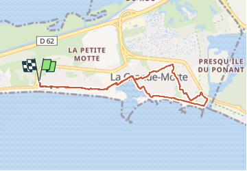
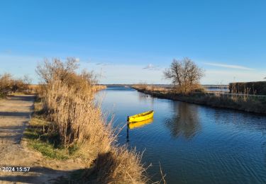
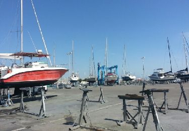
Tocht Stappen van 8,7 km beschikbaar op Occitanië, Hérault, La Grande-Motte. Deze tocht wordt voorgesteld door v.rabot.
Beschrijving
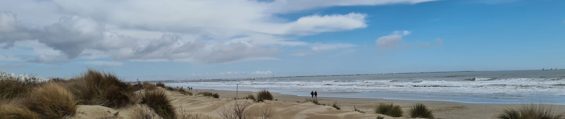
Petite marche sans aucune difficulté longent la mer à l'aller et passant dans les coulées vertes de La Grande Motte pour revenir par le port et le bord de mer
Plaatsbepaling
Land:
France
Regio :
Occitanië
Departement/Provincie :
Hérault
Gemeente :
La Grande-Motte
Locatie:
Unknown
Vertrek:(Dec)
Vertrek:(UTM)
585491 ; 4823500 (31T) N.
Opmerkingen
Wandeltochten in de omgeving
![Tocht Stappen Mauguio - sa 7 mars 2015 mauguio - Photo](https://media.geolcdn.com/t/375/260/ext.jpg?maxdim=2&url=https%3A%2F%2Fservices.sitytrail.com%2FGeolivesWS%2FDownloadMedia.ashx%3FTrailID%3D393117%26Media%3Dfix__20150307120533.jpg)
![Stappen Stappen](https://static1.geolcdn.com/sitytour/trail-icons/101.png)
sa 7 mars 2015 mauguio
Stappen
Heel gemakkelijk
(1)
Mauguio,
Occitanië,
Hérault,
France
![](/images/other/stat-length.png)
9,6 km | 9,8 km-effort
2h 23min
![](https://static1.geolcdn.com/siteimages/upload/files/16400158638029165_repeat_loop_refresh_sync_direction_icon.png)
Ja
![Tocht Stappen La Grande-Motte - L'empreinte de l'architecte Jean Balladur - Photo](https://media.geolcdn.com/t/375/260/ext.jpg?maxdim=2&url=https%3A%2F%2Fservices.sitytrail.com%2FGeolivesWS%2FDownloadMedia.ashx%3FTrailID%3D343894%26Media%3Dfix__20140910145554.jpg)
![Stappen Stappen](https://static1.geolcdn.com/sitytour/trail-icons/101.png)
L'empreinte de l'architecte Jean Balladur
Stappen
Heel gemakkelijk
(1)
La Grande-Motte,
Occitanië,
Hérault,
France
![](/images/other/stat-length.png)
7,7 km | 8,4 km-effort
1h 43min
![](https://static1.geolcdn.com/siteimages/upload/files/16400158638029165_repeat_loop_refresh_sync_direction_icon.png)
Neen
![Tocht Mountainbike La Grande-Motte - canal aigues mortes - Photo](https://media.geolcdn.com/t/375/260/ext.jpg?maxdim=2&url=https%3A%2F%2Fservices.sitytrail.com%2FGeolivesWS%2FDownloadMedia.ashx%3FTrailID%3D216094%26Media%3Dfix__20130823103155.jpg)
![Mountainbike Mountainbike](https://static1.geolcdn.com/sitytour/trail-icons/202.png)
canal aigues mortes
Mountainbike
Medium
(3)
La Grande-Motte,
Occitanië,
Hérault,
France
![](/images/other/stat-length.png)
41 km | 43 km-effort
2h 18min
![](https://static1.geolcdn.com/siteimages/upload/files/16400158638029165_repeat_loop_refresh_sync_direction_icon.png)
Ja
![Tocht Stappen Mauguio - les_cabanettes_Mauguio - Photo](https://media.geolcdn.com/t/375/260/ext.jpg?maxdim=2&url=https%3A%2F%2Fmedia.geolcdn.com%2Ff%2Ff7cfc759-102c-4881-93ab-ad949d8cfb24.jpg)
![Stappen Stappen](https://static1.geolcdn.com/sitytour/trail-icons/101.png)
les_cabanettes_Mauguio
Stappen
Gemakkelijk
Mauguio,
Occitanië,
Hérault,
France
![](/images/other/stat-length.png)
6,3 km | 6,5 km-effort
1h 28min
![](https://static1.geolcdn.com/siteimages/upload/files/16400158638029165_repeat_loop_refresh_sync_direction_icon.png)
Ja
![Tocht Stappen La Grande-Motte - La Grande Motte-Le Boucanet-La plage - Photo](https://media.geolcdn.com/t/375/260/ext.jpg?maxdim=2&url=https%3A%2F%2Fmedia.geolcdn.com%2Ff%2F92b9b7c2-ad64-4597-a39e-e96f68dd361a.jpg)
![Stappen Stappen](https://static1.geolcdn.com/sitytour/trail-icons/101.png)
La Grande Motte-Le Boucanet-La plage
Stappen
Medium
La Grande-Motte,
Occitanië,
Hérault,
France
![](/images/other/stat-length.png)
13,7 km | 14,5 km-effort
2h 59min
![](https://static1.geolcdn.com/siteimages/upload/files/16400158638029165_repeat_loop_refresh_sync_direction_icon.png)
Ja
![Tocht Stappen La Grande-Motte - 34 - La Grande Motte - Le Grau du Roi - Tour du lac du Ponant - 13,00 km - 3h00.gpx - Photo](https://media.geolcdn.com/t/375/260/ext.jpg?maxdim=2&url=https%3A%2F%2Fstatic1.geolcdn.com%2Fsiteimages%2Fupload%2Ffiles%2F1553511878bg_sport_marche.png)
![Stappen Stappen](https://static1.geolcdn.com/sitytour/trail-icons/101.png)
34 - La Grande Motte - Le Grau du Roi - Tour du lac du Ponant - 13,00 km - 3h...
Stappen
Medium
(1)
La Grande-Motte,
Occitanië,
Hérault,
France
![](/images/other/stat-length.png)
13 km | 13,7 km-effort
3h 5min
![](https://static1.geolcdn.com/siteimages/upload/files/16400158638029165_repeat_loop_refresh_sync_direction_icon.png)
Ja
![Tocht Stappen La Grande-Motte - La Grande Motte, visite du couchant - Photo](https://media.geolcdn.com/t/375/260/ext.jpg?maxdim=2&url=https%3A%2F%2Fservices.sitytrail.com%2FGeolivesWS%2FDownloadMedia.ashx%3FTrailID%3D350392%26Media%3Dfix__20140718161954.jpg)
![Stappen Stappen](https://static1.geolcdn.com/sitytour/trail-icons/101.png)
La Grande Motte, visite du couchant
Stappen
Gemakkelijk
La Grande-Motte,
Occitanië,
Hérault,
France
![](/images/other/stat-length.png)
5,2 km | 5,6 km-effort
1h 26min
![](https://static1.geolcdn.com/siteimages/upload/files/16400158638029165_repeat_loop_refresh_sync_direction_icon.png)
Neen
![Tocht Stappen La Grande-Motte - La Grande Motte, visite du couchant - Photo](https://media.geolcdn.com/t/375/260/ext.jpg?maxdim=2&url=https%3A%2F%2Fservices.sitytrail.com%2FGeolivesWS%2FDownloadMedia.ashx%3FTrailID%3D325648%26Media%3Dfix__20140718161954.jpg)
![Stappen Stappen](https://static1.geolcdn.com/sitytour/trail-icons/101.png)
La Grande Motte, visite du couchant
Stappen
Gemakkelijk
La Grande-Motte,
Occitanië,
Hérault,
France
![](/images/other/stat-length.png)
5,2 km | 5,6 km-effort
1h 26min
![](https://static1.geolcdn.com/siteimages/upload/files/16400158638029165_repeat_loop_refresh_sync_direction_icon.png)
Neen
![Tocht Noords wandelen Mauguio - étang de MAUGUIO - Photo](https://media.geolcdn.com/t/375/260/ext.jpg?maxdim=2&url=https%3A%2F%2Fstatic1.geolcdn.com%2Fsiteimages%2Fupload%2Ffiles%2F1545311037marcheuse_200dpi.jpg)
![Noords wandelen Noords wandelen](https://static1.geolcdn.com/sitytour/trail-icons/102.png)
étang de MAUGUIO
Noords wandelen
Medium
(1)
Mauguio,
Occitanië,
Hérault,
France
![](/images/other/stat-length.png)
9,6 km | 9,8 km-effort
1h 53min
![](https://static1.geolcdn.com/siteimages/upload/files/16400158638029165_repeat_loop_refresh_sync_direction_icon.png)
Ja