Tocht Mountainbike Montrozier - VTT Gages-Palanges Magalie 38km 750D+ 2021-06-19 - Photo

VTT Gages-Palanges Magalie 38km 750D+ 2021-06-19

© OpenStreetMap contributors
Lengte
Lengte
38 km
Max. hoogte
Max. hoogte
860 m
Positief hoogteverschil
681 m
Km-Effort
Km-Effort  
47 km
Min. hoogte
Min. hoogte
551 m
Negatief hoogteverschil
680 m
Boucle
Boucle
Ja
Datum van aanmaak :
2021-12-23 15:33:16.672
Laatste wijziging :
2021-12-23 15:35:58.369

(0 Bericht)

Mountainbike
Mountainbike
--
Moeilijkheid : Medium

Scan deze QR-code om de tocht te openen in de SityTrail-applicatie

Gratisgps-wandelapplicatie

Logo SityTrail SityTrail

IGN / Geografische instituten

SityTrail uit de App Store downloaden SityTrail uit Google Play downloaden

Logo SityTrail SityTrail World

De wereld gaat voor u open

SityTrail uit de App Store downloaden SityTrail uit Google Play downloaden SityTrail op Huawei AppGallery downloaden

Over ons

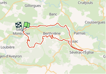
Tocht Mountainbike van 38 km beschikbaar op Occitanië, Aveyron, Montrozier. Deze tocht wordt voorgesteld door Levillefranchois.

Beschrijving

Parcours très agréable dans l'ensemble et même ludique dans la forêt des Palanges

Hoogteprofiel

Plaatsbepaling

Land:
France
Regio :
Occitanië
Departement/Provincie :
Aveyron
Gemeente :
Montrozier
Locatie:
Unknown
Vertrek:(UTM)
476767 ; 4916051 (31T) N.

Wandeltochten in de omgeving

Tocht Stappen Bozouls - Horizons et Clochers du Rouergue - Gillorgues - Photo
Stappen
tracegps

Stappen

Medium
Bozouls, Occitanië, Aveyron, France
11,9 km | 15,5 km-effort
3h 0min
Ja
Tocht Moto-cross Montrozier - av cl 2024 - Photo
Moto-cross
frank12

Moto-cross

Heel gemakkelijk
Montrozier, Occitanië, Aveyron, France
30 km | 42 km-effort
1h 0min
Neen
Tocht Stappen Montrozier - Gages Campeyroux - Photo
Stappen
Rere1947

Stappen

Montrozier, Occitanië, Aveyron, France
8,4 km | 9,7 km-effort
1h 52min
Ja
Tocht Stappen Bozouls - Gillorgues - Photo
Stappen
Lacaze

Stappen

Medium
Bozouls, Occitanië, Aveyron, France
10,9 km | 14,1 km-effort
3h 11min
Ja
Tocht Stappen Montrozier - causse comtal - Photo
Stappen
Lacaze

Stappen

Gemakkelijk
Montrozier, Occitanië, Aveyron, France
7 km | 8,1 km-effort
1h 46min
Ja
Tocht Mountainbike Bozouls - Aboul - Photo
Mountainbike
bonnetchristian

Mountainbike

Heel gemakkelijk
Bozouls, Occitanië, Aveyron, France
5,4 km | 6,9 km-effort
Onbekend
Ja
Tocht Mountainbike Montrozier - La Combe - Photo
Mountainbike
bonnetchristian

Mountainbike

Heel gemakkelijk
Montrozier, Occitanië, Aveyron, France
4,5 km | 5,4 km-effort
Onbekend
Ja
Tocht Mountainbike Montrozier - Gages - Photo
Mountainbike
bonnetchristian

Mountainbike

Heel gemakkelijk
Montrozier, Occitanië, Aveyron, France
4,7 km | 6 km-effort
Onbekend
Ja
Tocht Mountainbike Bozouls - Route de César - Photo
Mountainbike
bonnetchristian

Mountainbike

Heel gemakkelijk
Bozouls, Occitanië, Aveyron, France
6,7 km | 8,4 km-effort
Onbekend
Ja


Sluiten
Mijn abonnementen