![](/images/other/stat-length.png)
![Tocht Stappen Créhange - Créhange et environs - ballade 01 - Photo](https://media.geolcdn.com/t/1900/400/ext.pjpeg?maxdim=2&url=https%3A%2F%2Fstatic1.geolcdn.com%2Fsiteimages%2Fupload%2Ffiles%2F1553511878bg_sport_marche.png)
Créhange et environs - ballade 01
vinmed
Gebruiker
![Lengte](/images/other/stat-length.png)
Lengte
8,2 km
![Max. hoogte](https://static1.geolcdn.com/siteimages/upload/files/1508320355ic_sort_altitude_max_24dp.png)
Max. hoogte
401 m
![Positief hoogteverschil](https://static1.geolcdn.com/siteimages/upload/files/1508320355ic_sort_den_pos_24dp.png)
Positief hoogteverschil
135 m
![Km-Effort](/images/other/stat-length.png)
Km-Effort
10 km
![Min. hoogte](https://static1.geolcdn.com/siteimages/upload/files/1508320355ic_sort_altitude_min_24dp.png)
Min. hoogte
308 m
![Negatief hoogteverschil](https://static1.geolcdn.com/siteimages/upload/files/1508320355ic_sort_den_neg_24dp.png)
Negatief hoogteverschil
137 m
![Boucle](https://static1.geolcdn.com/siteimages/upload/files/16400158638029165_repeat_loop_refresh_sync_direction_icon.png)
Boucle
Ja
Datum van aanmaak :
2020-07-13 11:43:56.833
Laatste wijziging :
2020-07-13 16:31:12.716
![Stappen](https://static1.geolcdn.com/sitytour/trail-icons/101.png)
1h43
Moeilijkheid : Gemakkelijk
![Scan deze QR-code om de tocht te openen in de SityTrail-applicatie](https://capi.geolives.com/qq0zvz2zws4bq2lad0pu/sitytour/trails/2473624/qr.png?size=200)
Gratisgps-wandelapplicatie
Over ons
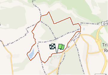
Tocht Stappen van 8,2 km beschikbaar op Grand Est, Moselle, Créhange. Deze tocht wordt voorgesteld door vinmed.
Beschrijving
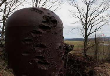
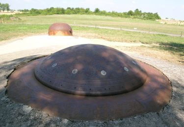
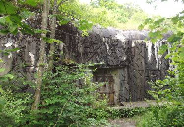
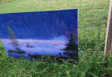
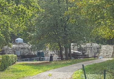
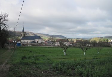
Promenade sympa à pied ou à vélo. Un tronçon sur une voie romaine. Au point culminant un beau panorama sur la vallée de la Nied, le Mont Saint Pierre et au loin les côtes de Moselle.
Plaatsbepaling
Land:
France
Regio :
Grand Est
Departement/Provincie :
Moselle
Gemeente :
Créhange
Locatie:
Unknown
Vertrek:(Dec)
Vertrek:(UTM)
323819 ; 5438763 (32U) N.
Opmerkingen
Wandeltochten in de omgeving
![Tocht Stappen Bambiderstroff - Circuit de la Vallée du Bambesch - Bambiderstroff - Photo](https://media.geolcdn.com/t/375/260/ext.jpg?maxdim=2&url=https%3A%2F%2Fservices.sitytrail.com%2FGeolivesWS%2FDownloadMedia.ashx%3FTrailID%3D317356%26Media%3D16574_3.jpg)
![Stappen Stappen](https://static1.geolcdn.com/sitytour/trail-icons/101.png)
Circuit de la Vallée du Bambesch - Bambiderstroff
Stappen
Medium
(1)
Bambiderstroff,
Grand Est,
Moselle,
France
![](/images/other/stat-length.png)
16,5 km | 20 km-effort
4h 0min
![](https://static1.geolcdn.com/siteimages/upload/files/16400158638029165_repeat_loop_refresh_sync_direction_icon.png)
Ja
![Tocht Te voet Bambiderstroff - Circuit Vallée du Bambesh - Photo](https://media.geolcdn.com/t/375/260/ext.jpg?maxdim=2&url=https%3A%2F%2Fmedia.geolcdn.com%2Ff%2F51b1a2b1-1ec9-4c3b-8398-f4e9bbf4c4bc.jpeg)
![Te voet Te voet](https://static1.geolcdn.com/sitytour/trail-icons/100.png)
Circuit Vallée du Bambesh
Te voet
Gemakkelijk
Bambiderstroff,
Grand Est,
Moselle,
France
![](/images/other/stat-length.png)
14,6 km | 17,9 km-effort
4h 3min
![](https://static1.geolcdn.com/siteimages/upload/files/16400158638029165_repeat_loop_refresh_sync_direction_icon.png)
Ja
![Tocht Te voet Pontpierre - Circuit du golf - Photo](https://media.geolcdn.com/t/375/260/ext.jpg?maxdim=2&url=https%3A%2F%2Fmedia.geolcdn.com%2Ff%2F5b67d3d5-1b0b-431c-87f2-59e1ee4107d1.jpeg)
![Te voet Te voet](https://static1.geolcdn.com/sitytour/trail-icons/100.png)
Circuit du golf
Te voet
Gemakkelijk
Pontpierre,
Grand Est,
Moselle,
France
![](/images/other/stat-length.png)
16 km | 19,4 km-effort
4h 24min
![](https://static1.geolcdn.com/siteimages/upload/files/16400158638029165_repeat_loop_refresh_sync_direction_icon.png)
Ja
![Tocht Stappen Pontpierre - expo nature Faulquemont - Photo](https://media.geolcdn.com/t/375/260/ext.jpg?maxdim=2&url=https%3A%2F%2Fmedia.geolcdn.com%2Ff%2F2a55ce1a-f77f-44c0-a977-0be5053c1376.jpg)
![Stappen Stappen](https://static1.geolcdn.com/sitytour/trail-icons/101.png)
expo nature Faulquemont
Stappen
Heel gemakkelijk
Pontpierre,
Grand Est,
Moselle,
France
![](/images/other/stat-length.png)
3,6 km | 4,3 km-effort
2h 46min
![](https://static1.geolcdn.com/siteimages/upload/files/16400158638029165_repeat_loop_refresh_sync_direction_icon.png)
Neen
![Tocht Stappen Longeville-lès-Saint-Avold - Longeville - Bambiderstroff - Photo](https://media.geolcdn.com/t/375/260/ext.jpg?maxdim=2&url=https%3A%2F%2Fstatic1.geolcdn.com%2Fsiteimages%2Fupload%2Ffiles%2F1553511878bg_sport_marche.png)
![Stappen Stappen](https://static1.geolcdn.com/sitytour/trail-icons/101.png)
Longeville - Bambiderstroff
Stappen
Gemakkelijk
(1)
Longeville-lès-Saint-Avold,
Grand Est,
Moselle,
France
![](/images/other/stat-length.png)
10,4 km | 13,7 km-effort
2h 56min
![](https://static1.geolcdn.com/siteimages/upload/files/16400158638029165_repeat_loop_refresh_sync_direction_icon.png)
Ja
![Tocht Noords wandelen Bambiderstroff - Eric Bambiderstroff - Photo](https://media.geolcdn.com/t/375/260/ext.jpg?maxdim=2&url=https%3A%2F%2Fservices.sitytrail.com%2FGeolivesWS%2FDownloadMedia.ashx%3FTrailID%3D470932%26Media%3Dfix__20150912113220.jpg)
![Noords wandelen Noords wandelen](https://static1.geolcdn.com/sitytour/trail-icons/102.png)
Eric Bambiderstroff
Noords wandelen
Gemakkelijk
Bambiderstroff,
Grand Est,
Moselle,
France
![](/images/other/stat-length.png)
14,8 km | 18,4 km-effort
2h 35min
![](https://static1.geolcdn.com/siteimages/upload/files/16400158638029165_repeat_loop_refresh_sync_direction_icon.png)
Ja
![Tocht Stappen Bambiderstroff - Tour de Bambiderstroff - Photo](https://media.geolcdn.com/t/375/260/ext.jpg?maxdim=2&url=https%3A%2F%2Fservices.sitytrail.com%2FGeolivesWS%2FDownloadMedia.ashx%3FTrailID%3D259797%26Media%3D80b171ff-8848-4e27-8d63-405486baa858.JPG)
![Stappen Stappen](https://static1.geolcdn.com/sitytour/trail-icons/101.png)
Tour de Bambiderstroff
Stappen
Medium
Bambiderstroff,
Grand Est,
Moselle,
France
![](/images/other/stat-length.png)
12,8 km | 15,8 km-effort
3h 50min
![](https://static1.geolcdn.com/siteimages/upload/files/16400158638029165_repeat_loop_refresh_sync_direction_icon.png)
Ja
![Tocht Te voet Elvange - Circuit de Walving - Photo](https://media.geolcdn.com/t/375/260/ext.jpg?maxdim=2&url=https%3A%2F%2Fstatic1.geolcdn.com%2Fsiteimages%2Fupload%2Ffiles%2F1545311037marcheuse_200dpi.jpg)
![Te voet Te voet](https://static1.geolcdn.com/sitytour/trail-icons/100.png)
Circuit de Walving
Te voet
Gemakkelijk
Elvange,
Grand Est,
Moselle,
France
![](/images/other/stat-length.png)
13,7 km | 16,7 km-effort
3h 47min
![](https://static1.geolcdn.com/siteimages/upload/files/16400158638029165_repeat_loop_refresh_sync_direction_icon.png)
Ja
![Tocht Te voet Longeville-lès-Saint-Avold - Circuit de St Martin-en-Glandière - Photo](https://media.geolcdn.com/t/375/260/ext.jpg?maxdim=2&url=https%3A%2F%2Fstatic1.geolcdn.com%2Fsiteimages%2Fupload%2Ffiles%2F1545311037marcheuse_200dpi.jpg)
![Te voet Te voet](https://static1.geolcdn.com/sitytour/trail-icons/100.png)
Circuit de St Martin-en-Glandière
Te voet
Gemakkelijk
Longeville-lès-Saint-Avold,
Grand Est,
Moselle,
France
![](/images/other/stat-length.png)
4,3 km | 6,4 km-effort
1h 27min
![](https://static1.geolcdn.com/siteimages/upload/files/16400158638029165_repeat_loop_refresh_sync_direction_icon.png)
Neen