Tocht Mountainbike Camon - voie verte Camon Ste Colombe sur l'Hers - Photo

voie verte Camon Ste Colombe sur l'Hers

 jopost
jopost

Gebruiker

© OpenStreetMap contributors
Lengte
Lengte
13,3 km
Max. hoogte
Max. hoogte
417 m
Positief hoogteverschil
207 m
Km-Effort
Km-Effort  
15,8 km
Min. hoogte
Min. hoogte
345 m
Negatief hoogteverschil
149 m
Boucle
Boucle
Neen
Datum van aanmaak :
2017-01-09 00:00:00.0
Laatste wijziging :
2017-01-09 00:00:00.0

(1 Bericht)

Mountainbike
Mountainbike
1h07
Moeilijkheid : Medium

Scan deze QR-code om de tocht te openen in de SityTrail-applicatie

Gratisgps-wandelapplicatie

Logo SityTrail SityTrail

IGN / Geografische instituten

SityTrail uit de App Store downloaden SityTrail uit Google Play downloaden

Logo SityTrail SityTrail World

De wereld gaat voor u open

SityTrail uit de App Store downloaden SityTrail uit Google Play downloaden SityTrail op Huawei AppGallery downloaden

Over ons

Tocht Mountainbike van 13,3 km beschikbaar op Occitanië, Ariège, Camon. Deze tocht wordt voorgesteld door jopost.

Beschrijving

voie verte très accessible

Hoogteprofiel

Foto's

Plaatsbepaling

Land:
France
Regio :
Occitanië
Departement/Provincie :
Ariège
Gemeente :
Camon
Locatie:
Unknown
Vertrek:(Dec)
Vertrek:(UTM)
415546 ; 4763570 (31T) N.

Opmerkingen

Gelieve in te loggen om een commentaar of een beoordeling achter te laten


pas toujours fiable


Wandeltochten in de omgeving

Tocht Stappen Montbel - Lac de Montbel - Photo
Stappen
tracegps

Stappen

Medium
(2)
Montbel, Occitanië, Ariège, France
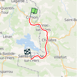
15,8 km | 18,4 km-effort
3h 19min
Ja
Tocht Mountainbike Léran - Lac de Montbel - Chalabre - Photo
Mountainbike
tracegps

Mountainbike

Medium
(1)
Léran, Occitanië, Ariège, France
25 km | 30 km-effort
3h 0min
Ja
Tocht Te voet Montbel - Tour du Lac de Montbel - Photo
Te voet
PRO

Te voet

Gemakkelijk
Montbel, Occitanië, Ariège, France
15,3 km | 17,9 km-effort
4h 4min
Ja
Tocht Fiets Chalabre - Chalabre - Limoux - Espéraza - Photo
Fiets
tracegps

Fiets

Moeilijk
Chalabre, Occitanië, Aude, France
72 km | 88 km-effort
4h 30min
Ja
Tocht Paard Chalabre - La colline du calvaire - Chalabre - Photo
Paard
tracegps

Paard

Gemakkelijk
Chalabre, Occitanië, Aude, France
4,4 km | 6,4 km-effort
1h 0min
Ja
Tocht Stappen Chalabre - La colline du calvaire - Chalabre - Photo
Stappen
tracegps

Stappen

Gemakkelijk
Chalabre, Occitanië, Aude, France
4,4 km | 6,4 km-effort
1h 30min
Ja
Tocht Stappen Chalabre - Circuit de découverte de Chalabre - Photo
Stappen
tracegps

Stappen

Gemakkelijk
Chalabre, Occitanië, Aude, France
3,5 km | 3,9 km-effort
1h 0min
Ja
Tocht Paard Chalabre - Histoires d'eau et de train - Chalabre - Photo
Paard
tracegps

Paard

Moeilijk
Chalabre, Occitanië, Aude, France
23 km | 28 km-effort
4h 0min
Ja
Tocht Mountainbike Chalabre - Histoires d'eau et de train - Chalabre - Photo
Mountainbike
tracegps

Mountainbike

Medium
Chalabre, Occitanië, Aude, France
23 km | 28 km-effort
2h 0min
Ja


Sluiten
Mijn abonnementen